



Community hub
Recent from talks
Knowledge base stats:
Talk channels stats:
Members stats:
Cumberland Gap
The Cumberland Gap is a pass in the eastern United States through the long ridge of the Cumberland Mountains, within the Appalachian Mountains and near the tripoint of Kentucky, Virginia, and Tennessee. At an elevation of 1,631 feet (497 m) above sea level, it is famous in American colonial history for its role as a key passageway through the lower central Appalachians.
Long used by Native American nations, the Cumberland Gap was brought to the attention of settlers in 1750 by Thomas Walker, a Virginia physician and explorer. The path was used by a team of frontiersmen led by Daniel Boone, making it accessible to pioneers who used it to journey into the western frontiers of Kentucky and Tennessee. An important part of the Wilderness Road, it is now part of the Cumberland Gap National Historical Park.
The Cumberland Gap is one of many passes in the Appalachian Mountains, but one of the few in the continuous Cumberland Mountain ridgeline. It lies within Cumberland Gap National Historical Park and is located on the border of present-day Kentucky and Virginia, approximately 0.25 miles (0.40 km) northeast of the tri-state marker with Tennessee.
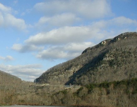
The V-shaped gap serves as a gateway to the west. The base of the gap is about three hundred feet (90 m) above the valley floor, even though the north side of the pass was lowered twenty feet (6 m) during the construction of Old U.S. Route 25E. To the south, the ridge rises six hundred feet (180 m) above the pass, while to the north the Pinnacle Overlook towers 900 feet (270 m) above at an elevation of 2,505 feet (765 m).
Centrally located in the eastern United States, the region around Cumberland Gap experiences all four seasons. The summers are typically sunny, warm, and humid with average high temperatures in the mid to upper 80s °F (29-32 °C). In the winter months, January through March, temperatures range in the 30s to 40s °F (0s °C) and are generally mild with rain and few periods of snow.
The nearest cities are Middlesboro, Kentucky and Harrogate, Tennessee. The nearby town of Cumberland Gap, Tennessee is named after the gap.
The gap was formed by the development of three major structural features: the Pine Mountain Thrust Sheet, the Middlesboro Syncline, and the Rocky Face Fault. Lateral compressive forces of sedimentary rocks from deep layers of the Earth's crust pushing upward 320 to 200 million years ago created the thrust sheet. Resistance on the fault from the opposing Cumberland Mountain to Pine Mountain caused the U-shaped structure of the Middlesboro Syncline. The once flat-lying sedimentary rocks were deformed roughly 40 degrees northwest. Further constriction to the northwest of Cumberland Mountain developed into a fault trending north-to-south called the Rocky Face Fault, which eventually cut through Cumberland Mountain. This combination of natural geological processes created ideal conditions for weathering and erosion of the rocks.
The discovery of the Middlesboro impact structure has proposed new details in the formation of Cumberland Gap. Less than 300 million years ago a meteorite, "approximately the size of a football field", struck the earth, creating the Middlesboro Crater. One of three astroblemes in the state, it is a 3.7 mi (6.0 km) diameter meteorite impact crater with the city of Middlesboro, Kentucky built entirely inside it. Detailed mapping by geologists in the 1960s led many to interpret the geological features of the area to be the site of an ancient impact. In 1966 Robert Dietz discovered shatter cones in nearby sandstone, proving recent speculation. Shatter cones, a rock-shattering pattern naturally formed only during impact events, are found in abundance in the area. The presence of shatter cones found also helped confirm the origin of the impact. In September 2003, the site was designated a Distinguished Geologic Site by the Kentucky Society of Professional Geologists.
Hub AI
Cumberland Gap AI simulator
(@Cumberland Gap_simulator)
Cumberland Gap
The Cumberland Gap is a pass in the eastern United States through the long ridge of the Cumberland Mountains, within the Appalachian Mountains and near the tripoint of Kentucky, Virginia, and Tennessee. At an elevation of 1,631 feet (497 m) above sea level, it is famous in American colonial history for its role as a key passageway through the lower central Appalachians.
Long used by Native American nations, the Cumberland Gap was brought to the attention of settlers in 1750 by Thomas Walker, a Virginia physician and explorer. The path was used by a team of frontiersmen led by Daniel Boone, making it accessible to pioneers who used it to journey into the western frontiers of Kentucky and Tennessee. An important part of the Wilderness Road, it is now part of the Cumberland Gap National Historical Park.
The Cumberland Gap is one of many passes in the Appalachian Mountains, but one of the few in the continuous Cumberland Mountain ridgeline. It lies within Cumberland Gap National Historical Park and is located on the border of present-day Kentucky and Virginia, approximately 0.25 miles (0.40 km) northeast of the tri-state marker with Tennessee.
The V-shaped gap serves as a gateway to the west. The base of the gap is about three hundred feet (90 m) above the valley floor, even though the north side of the pass was lowered twenty feet (6 m) during the construction of Old U.S. Route 25E. To the south, the ridge rises six hundred feet (180 m) above the pass, while to the north the Pinnacle Overlook towers 900 feet (270 m) above at an elevation of 2,505 feet (765 m).
Centrally located in the eastern United States, the region around Cumberland Gap experiences all four seasons. The summers are typically sunny, warm, and humid with average high temperatures in the mid to upper 80s °F (29-32 °C). In the winter months, January through March, temperatures range in the 30s to 40s °F (0s °C) and are generally mild with rain and few periods of snow.
The nearest cities are Middlesboro, Kentucky and Harrogate, Tennessee. The nearby town of Cumberland Gap, Tennessee is named after the gap.
The gap was formed by the development of three major structural features: the Pine Mountain Thrust Sheet, the Middlesboro Syncline, and the Rocky Face Fault. Lateral compressive forces of sedimentary rocks from deep layers of the Earth's crust pushing upward 320 to 200 million years ago created the thrust sheet. Resistance on the fault from the opposing Cumberland Mountain to Pine Mountain caused the U-shaped structure of the Middlesboro Syncline. The once flat-lying sedimentary rocks were deformed roughly 40 degrees northwest. Further constriction to the northwest of Cumberland Mountain developed into a fault trending north-to-south called the Rocky Face Fault, which eventually cut through Cumberland Mountain. This combination of natural geological processes created ideal conditions for weathering and erosion of the rocks.
The discovery of the Middlesboro impact structure has proposed new details in the formation of Cumberland Gap. Less than 300 million years ago a meteorite, "approximately the size of a football field", struck the earth, creating the Middlesboro Crater. One of three astroblemes in the state, it is a 3.7 mi (6.0 km) diameter meteorite impact crater with the city of Middlesboro, Kentucky built entirely inside it. Detailed mapping by geologists in the 1960s led many to interpret the geological features of the area to be the site of an ancient impact. In 1966 Robert Dietz discovered shatter cones in nearby sandstone, proving recent speculation. Shatter cones, a rock-shattering pattern naturally formed only during impact events, are found in abundance in the area. The presence of shatter cones found also helped confirm the origin of the impact. In September 2003, the site was designated a Distinguished Geologic Site by the Kentucky Society of Professional Geologists.