

Community hub
Recent from talks
Contribute something
Nothing was collected or created yet.
Tripoint
View on WikipediaThis article needs additional citations for verification. (July 2008) |

A triple border, tripoint,[citation needed] trijunction,[1] triple point, or tri-border area is a geographical point at which the boundaries of three countries or subnational entities meet. There are 175 international tripoints as of 2020.[2] Nearly half are situated in rivers, lakes or seas. On dry land, the exact tripoints may be indicated by markers or pillars, and occasionally by larger monuments.
Usually, the more neighbours a country has, the more international tripoints that country has. China with 16 international tripoints and Russia with 11 to 14 lead the list of states by number of international tripoints. Other countries, like Brazil, India, and Algeria, have several international tripoints. Argentina has four international tripoints. South Africa, Pakistan and Nigeria have three international tripoints, Guatemala has two: one with Mexico and Belize, and one with Honduras and El Salvador; while Bangladesh and Mexico have one. Within Europe, landlocked Austria has nine tripoints, among them two with Switzerland and Liechtenstein. Island countries, such as Japan and Australia, generally have no international tripoints, although some, like Bahrain and Singapore, have tripoints in their territorial waters. Countries with only one neighbouring country, such as Portugal or Lesotho, also have no international tripoints. Landlocked countries also have international tripoints. Likewise, the United States with two neighbouring countries has no international tripoints; however, it has a number of state tripoints as well as one point where four states meet. Indonesia has no international tripoints, just like Australia, Japan and the United States. Canada, as well, which has a maritime border with two other countries, has no international tripoints; however, it has five tripoints on land where the boundaries of provinces and territories meet, and one quadripoint where four provinces and territories meet. Japan has multiple prefectural tripoints; it also has prefectural quadripoints. In addition to the United States, Canada and Indonesia, Australia also has tripoints where the boundaries of states meet.
Border junctions (or "multiple points" or "multipoints" as they are also sometimes called) are most commonly threefold. There are also a number of quadripoints, and a handful of fivefold points, as well as unique examples of sixfold, sevenfold, and eightfold points (see quadripoint § Multipoints of greater numerical complexity). The territorial claims of six countries converge at the South Pole in a point of elevenfold complexity, though this is an example of points subject to dispute.
Examples
[edit]
International tripoints include:
- the Treriksröset of Finland, Norway, and Sweden (the northernmost international tripoint in the world; the exact point is in a lake, but a marker is built on that point)
- the Vaalserberg of the Netherlands, Germany, and Belgium
- the "Dreiländereck" of Germany, France, and Switzerland (the exact point is in the river and the marker is not on the exact point)
- the Schengen tripoint of Germany, France, and Luxembourg (where the Schengen Agreement was signed on board a boat, since the tripoint is in the river)
- the summit of Sia Kangri (near Indira Col) is the tripoint where territories administered by India, Pakistan, and China meet
- the Triple Frontier of Argentina, Brazil, and Paraguay
- the Tres Fronteras of Brazil, Peru, and Colombia
- the Mont Dolent of Italy, France, and Switzerland (the exact point is not at the peak but around 200 metres (700 ft) to the northwest)
- the Trójstyk of Poland, Czech Republic and Slovakia
- Mount Roraima, where Venezuela (not recognized by this one), Brazil, and Guyana all meet
- Jongsong Peak, the eastern tripoint of China, India and Nepal
- The Trifinio Fraternidad Transboundary Biosphere Reserve is a natural reserve shared between Honduras, Guatemala and El Salvador.
- Bratislava is the only capital city in the world which is located at a tripoint: Slovakia, Hungary, and Austria. The city's administrative area extends to the tripoint, but the point lies outside of urban Bratislava itself.
Some historic tripoints:
- the historic Three Emperors' Corner of Austria-Hungary, the Russian Empire, and German Empire
- the historic Piz da las Trais Linguas (Ortler Alps) of Austria-Hungary, the Kingdom of Italy, and Switzerland
- the historic Rock of the Three Kingdoms between the former kingdoms of Galicia, León, and Portugal (now part of the border between Kingdom of Spain and the Portuguese Republic)[3]
- the Tossal dels Tres Reis ('Peak of the Three Kings'), located where the borders of the ancient Kingdoms of Aragon, Valencia and Principality of Catalonia meet[4]
International agreements
[edit]
While the exact line of an international border is normally fixed by a bilateral treaty, the position of the tripoints may need to be settled by a trilateral agreement. For example, China, Russia, and Mongolia have set the position of the two relevant tripoints (the junction points of the China–Russia border, the Mongolia–Russia border, and the China–Mongolia border) by the trilateral agreement signed in Ulaanbaatar on January 27, 1994. The agreement specified that a marker was to be erected at the eastern tripoint, called Tarvagan Dakh (Tarbagan Dakha), but that no marker would be erected at the western tripoint (which was defined as the peak of the mountain Tavan-Bogdo-Ula (Kuitunshan, Tavan Bogd Uul).[5]
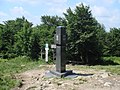
Gallery
[edit]-

-
 Dreiländereck Basel: Switzerland, Germany, and France
 -
 Europadenkmal: Germany, Belgium, and Luxembourg
 -
 Tripoint of Germany, Czech Republic, and Poland in Sudetes
 -
 Border stone on the tripoint of Poland (right of photograph), Slovakia, and Ukraine (left)
 -
 Treriksröset: Finland, Norway, and Sweden tripoint
 -
 Tripoint of Russia, Norway, and Finland
 -
 Arnoldstein: Italy, Slovenia, and Austria tripoint
 -

-
 Border stone on the tripoint of Bulgaria (right of photograph), Greece (left), and North Macedonia, located on the Tumba Peak
 -
 The tripoint of France, Italy, and Switzerland is located on Mont Dolent.
 -
 Border stone on the tripoint of Venezuela (foreground), Brazil, and Guyana located on Mount Roraima
 -

-
 Ceremonial marker near the tri-point of France, Germany and Luxembourg
 -
 Cameron Corner Survey Marker, the point where the borders of the Australian states of New South Wales, Queensland and South Australia meet

.jpg)


See also
[edit]References
[edit]- ^ Charney, Jonathan I.; Colson, David A.; Smith, Robert W. (2005). International Maritime Boundaries. Martinus Nijhoff. p. 3298. ISBN 978-90-04-14461-3.
- ^ "JISCMail - INT-BOUNDARIES Archives". www.jiscmail.ac.uk. Retrieved 10 April 2018.
- ^ Treaty on boundaries between Spain and Portugal from the mouth of the Minho River to the junction of the river Cay a with the Guadiana. Signed at Lisbon on 29 September 1864 Archived 19 May 2011 at the Wayback Machine
- ^ "Mapa Topogràfic de Catalunya". Institut Cartogràfic de Catalunya. Retrieved May 22, 2010..
- ^ Соглашением между Правительством Российской Федерации, Правительством Китайской Народной Республики и Правительством Монголии об определении точек стыков государственных границ трех государств (Заключено в г. Улан-Баторе 27 января 1994 года) Archived 2016-03-05 at the Wayback Machine (The Agreement between the Government of the Russian Federation, the Government of the People's Republic of China, and the Government of Mongolia on the determination of the points of junction of the national borders of the three states)
External links
[edit]Tripoint
View on GrokipediaDefinition and Classification
Core Definition
A tripoint is a geographical point at which the boundaries of three countries or subnational entities meet.[6] This convergence occurs where two bilateral border lines intersect, forming a single location shared by the three territories. Tripoints can be classified as international, involving sovereign states, or domestic, involving administrative divisions within one country, such as U.S. states.[7] The demarcation of tripoints typically results from treaties, surveys, and negotiations between the involved parties, often marked by border stones, cairns, or monuments to signify the exact location.[4] In some cases, tripoints are situated on natural features like mountain peaks or river confluences, which can complicate precise boundary definition due to terrain variability or hydrological changes. Dry tripoints lie entirely on land, while wet tripoints are defined by water bodies such as rivers or lakes, where the border follows the thalweg or midline.[4] While most tripoints are stable, discrepancies may arise from historical agreements, measurement errors, or territorial disputes, leading to small disputed zones around the nominal point. For instance, international tripoints require coordination among three states, increasing the potential for diplomatic sensitivities compared to bilateral borders.[8]Types of Tripoints
International tripoints, where the boundaries of three sovereign states intersect, form the primary category of such geopolitical features. As of 2023, approximately 175 international tripoints exist worldwide, with Africa hosting the highest number at 61, followed by Asia with 51 and Europe with 48.[1] These points often serve as markers for border demarcation, established through bilateral or multilateral treaties, and can influence regional security and trade dynamics. Within international tripoints, a key distinction arises between dry tripoints on terrestrial land and wet tripoints along water bodies such as rivers or lakes. Dry tripoints, comprising the majority, occur on solid ground, frequently marked by border stones or monuments for visibility and enforcement. Examples include the Treriksröset tripoint between Finland, Norway, and Sweden, situated in a remote forested area and accessible via hiking trails. Wet tripoints, conversely, lie at the confluence of waterways, complicating demarcation due to shifting watercourses and requiring hydrographic surveys for precision. The tripoint of Brazil, Paraguay, and Argentina at the junction of the Iguazú and Paraná rivers exemplifies this type, where the dynamic river boundaries necessitate periodic reaffirmation through diplomatic agreements.[4] Subnational tripoints, or internal tripoints, represent another major category, occurring where three administrative divisions within a single country converge. These are common in federal systems with multiple subnational units, such as the 62 tripoints among U.S. states, including 38 on dry land and 24 in water bodies like rivers or the Great Lakes. Unlike international tripoints, subnational ones typically lack the geopolitical tensions associated with sovereignty but can still impact local governance, resource allocation, and infrastructure planning. In larger nations like Russia or Canada, similar internal tripoints exist among provinces or oblasts, often undocumented in global counts focused on cross-border junctions.[7][4] Maritime tripoints, though less commonly emphasized in terrestrial-focused discussions, denote points where the exclusive economic zones or territorial waters of three states meet at sea. These are defined primarily by international maritime law, such as the United Nations Convention on the Law of the Sea, and are critical for fisheries, hydrocarbon exploration, and navigation rights, but they differ from land tripoints by lacking physical markers and relying on coordinates derived from equidistance principles or negotiated delimitations.[3]Historical Context
Origins and Early Recognition
The convergence of three territorial boundaries, forming what is now termed a tripoint, arose organically as polities expanded and abutted one another, predating modern state systems; however, systematic recognition and demarcation occurred with the advent of precise border treaties in Europe during the 18th century. Following the partitions of Poland—specifically the First Partition in 1772, Second in 1793, and Third in 1795—the borders of the Russian Empire, Kingdom of Prussia, and Habsburg Monarchy (Austria) met at a point near the confluence of the Black and White Przemsza Rivers in present-day Sosnowiec, Poland. This location, retrospectively dubbed the Three Emperors' Corner after German unification in 1871 elevated Prussia to imperial status, represented an early instance of a formally acknowledged international tripoint amid the reconfiguration of Central European territories.[9] By the mid-19th century, growing emphasis on nationalism and territorial sovereignty prompted more deliberate surveys and markings of such points, often tied to tourism and symbolic commemoration. One of Europe's earliest documented tripoints attracting visitors was the junction of the Austro-Hungarian Empire, Russian Empire, and Kingdom of Romania, highlighting the geopolitical intrigue of these convergences. In parallel, Scandinavian states formalized their tripoint through a stone cairn erected in 1897 at Treriksröset, where Sweden, Norway, and Finland (then under Russian administration) meet, reflecting advancements in geodesy and bilateral agreements post-Norwegian independence from Sweden in 1905.[2][8] The term "tripoint" (or equivalents like "trifinium" in Latin-derived contexts) gained usage in 20th-century geographical and legal discourse to denote these precise intersections, distinct from quadripoints or bilateral endpoints, as international boundary commissions increasingly addressed trilateral overlaps in treaties and delimitations. Early American examples, such as the Argentina-Bolivia-Chile tripoint established implicitly upon Argentine independence in 1810 and surveyed via the 1889 AB accord atop Mount Zapaleri, illustrate how colonial legacies and post-independence pacts extended this recognition beyond Europe.[10]Evolution in Border Formation
Tripoints have historically arisen as incidental outcomes of territorial consolidation through conquest, dynastic unions, and early diplomatic delimitations, often without precise demarcation until the modern era. In pre-modern Europe, fluid feudal and imperial boundaries rarely fixed tripoints with monuments or treaties, as sovereignty was more personal than territorial. A notable early example emerged in Central Europe following the partitions of Poland (1772, 1793, 1795), which divided the Polish-Lithuanian Commonwealth among Russia, Prussia, and Austria, setting the stage for tripoints; the unification of Germany in 1871 then created the Three Emperors' Corner near Mysłowice, where the German Empire, Russian Empire, and Austria-Hungary converged at the Przemsza Rivers until World War I redrew the map in 1915.[9] This site exemplified how 19th-century nationalism and state-building formalized tripoints, attracting early tourism by the mid-1800s due to its symbolic geopolitical significance.[2] The 20th century accelerated tripoint formation through major geopolitical upheavals and border revisions. Post-World War I treaties, including the Treaty of Versailles (signed June 28, 1919), dismantled empires and established new states like Poland and Lithuania, yielding tripoints such as the Lithuania-Poland-Russia junction formalized in 1919 amid the Polish-Soviet War's aftermath.[11] Similar delimitations under the Treaty of Lausanne (July 24, 1923) adjusted Ottoman remnants, creating riverine tripoints like Greece-Turkey-Bulgaria in the Maritsa River, where subsequent channel shifts formed disputed islands. In Europe, these changes proliferated tripoints from roughly a dozen stable ones pre-1914 to over 40 by mid-century, reflecting the shift from imperial fluidity to rigid nation-state borders enforced by international commissions.[11] Decolonization post-World War II further multiplied tripoints, particularly in Africa and Asia, by inheriting arbitrary colonial boundaries that ignored geographic or ethnic realities. The Berlin Conference (1884–1885) imposed straight-line divisions among European powers, generating latent tripoints where three colonies abutted; independence waves—such as Ghana in 1957, followed by over 50 African states by 1968—crystallized these into international junctions, with Africa now hosting the highest number at 61 land tripoints. In Asia, partitions like India's 1947 division and subsequent recognitions created tripoints such as India-China-Pakistan (disputed since 1963). Late-20th-century state dissolutions, including the Soviet Union's 1991 breakup into 15 republics and Yugoslavia's fragmentation (1991–2006), added over a dozen new tripoints, such as Russia-Kazakhstan-China, underscoring how secession preserves or shifts prior delimitations rather than erasing them.[5] This evolution reflects causal drivers like war outcomes and anti-colonial legal inheritance, prioritizing stability over revision despite frequent disputes at these confluences.Legal Framework
International Law Principles
International boundaries at tripoints, where the territories of three sovereign states converge, are delimited primarily through mutual consent manifested in bilateral or multilateral treaties, as boundary determination inherently requires the agreement of all affected states under customary international law.[12] This principle derives from the sovereignty of states over their territory, ensuring that no delimitation imposes obligations on third states without their acquiescence, in line with the non-opposability of treaties to non-parties as codified in the Vienna Convention on the Law of Treaties (1969). For land tripoints, treaties often specify coordinates or natural features marking the exact convergence point, with stability prioritized to uphold territorial integrity; deviations arise only through subsequent negotiated adjustments or adjudications.[13] In post-colonial contexts, the uti possidetis juris principle serves as a default rule, preserving administrative boundaries inherited from colonial entities at independence to minimize disputes, including at tripoints.[12] Applied notably in Latin America since the 19th century and Africa following decolonization in the 1960s, it freezes pre-independence lines unless explicitly altered by treaty, as affirmed in International Court of Justice (ICJ) jurisprudence such as the 1986 Burkina Faso/Mali case, where uti possidetis was deemed applicable to land boundaries without direct reference to tripoints but influencing their alignment. However, this principle does not automatically resolve tripoint ambiguities, necessitating supplementary agreements to reconcile potentially inconsistent bilateral delimitations. Maritime tripoints, governed by the United Nations Convention on the Law of the Sea (UNCLOS, 1982), mandate delimitation by agreement to achieve an equitable solution, with Articles 74 and 83 applying to exclusive economic zones and continental shelves. Tribunals employ a three-stage methodology: first, establishing a provisional equidistance line from coastal baselines; second, adjusting for relevant circumstances like coastline configuration; and third, verifying proportionality and equity, as in the 2012 Bangladesh/Myanmar case where a tripoint with India was coordinated via bilateral extensions. Absent agreement, provisional application of equidistance avoids prejudice, but tripoints often demand trilateral negotiation to prevent overlaps, reflecting the convention's emphasis on cooperative boundary-making over rigid formulas.[5]Treaty-Based Delimitation
Treaty-based delimitation of tripoints relies on bilateral agreements between pairs of states to define the course of their respective borders, with the tripoint forming at the intersection of these lines. These treaties establish the boundary through legal descriptions, including coordinates, textual provisions, and accompanying maps at scales such as 1:50,000 or 1:100,000, ensuring the abstract lines converge without ambiguity.[13] The process prioritizes precise specification of starting and ending points, including tripoints, to facilitate subsequent demarcation on the ground.[13] International law upholds such treaties as binding, with boundaries inviolable except by mutual consent, drawing on principles like uti possidetis juris for post-colonial states where inherited treaties fix the lines.[13] Where bilateral treaties result in discrepancies at the convergence point, trilateral agreements may be negotiated to resolve inconsistencies and fix a single location.[13] This involves joint commissions from all three states producing unified maps, protocols, and demarcation documents, often with high-precision geodetic surveys to achieve accuracies of 0.1 mm on coordinate grids.[13] For instance, the tripoint between Belarus, Lithuania, and Latvia was delimited through multilateral coordination, including the erection of center monuments and summary protocols signed by representatives of each state.[13] In practice, land tripoints demand coordinated efforts beyond bilateral pairs, as seen in the 1994 trilateral agreement among China, Russia, and Mongolia, which precisely located their two shared tripoints following earlier bilateral delimitations like the 1962 China-Mongolia boundary treaty that extended to the western tripoint with the Soviet Union (predecessor to Russia).[14] Such arrangements prevent disputes by reconciling any offsets in pairwise lines, with treaties entering force after domestic ratification and notification exchanges.[13] Demarcation then follows, placing permanent markers at the tripoint, such as pillars or monuments, within reserved areas to account for minor deviations up to 3 meters.[13]Geopolitical and Practical Significance
Diplomatic and Security Roles
Tripoints often necessitate trilateral diplomatic agreements to delimit boundaries precisely, as bilateral treaties may fail to resolve convergence points, potentially leading to territorial ambiguities or disputes. Such multilateral pacts ensure clear jurisdictional lines and prevent inadvertent encroachments, with examples including protocols specifying exact coordinates or markers at the junction.[13] In practice, these negotiations foster dialogue among states, sometimes extending to joint commissions for ongoing boundary management and dispute prevention.[5] From a security standpoint, tripoints amplify vulnerabilities to transnational threats, as criminals exploit jurisdictional overlaps to evade capture, facilitating activities like drug trafficking, arms smuggling, and terrorism financing. Remote or porous tripoints, particularly in underdeveloped regions, enable cross-border networks to operate with reduced detection risk, complicating unilateral enforcement efforts.[15] [16] To counter these risks, states engage in trilateral security cooperation, including joint patrols, intelligence sharing, and task forces tailored to tripoint dynamics. For example, the Triple Frontier between Argentina, Brazil, and Paraguay—marked by the confluence of the Iguazú and Paraná rivers—has seen enhanced collaboration through mechanisms like the 3+1 Group (involving the three nations and the United States) to combat organized crime linked to groups such as Hezbollah, with operations yielding arrests and seizures since the early 2000s.[16] Similarly, the Brazil-Colombia-Peru Amazon tripoint has prompted coordinated efforts against cocaine production and trafficking, though challenges persist due to vast terrain and limited resources.[15] These arrangements underscore tripoints' role in compelling interstate partnerships for regional stability, balancing sovereignty with collective defense against non-state actors.Economic and Cultural Impacts
Tripoints can stimulate local economies through transboundary tourism, where the geographic novelty of accessing three jurisdictions in close proximity draws visitors for multi-country experiences, such as guided tours or events spanning borders. Academic analysis identifies synergies in tripoint areas for developing shared tourist attractions and cultural festivals, potentially enhancing revenue in underdeveloped border regions, though success depends on infrastructure and political cooperation.[2] For example, in the Poland-Belarus-Ukraine tri-border area, entrepreneurial ecosystems for regional tourism have emerged, capitalizing on natural and historical sites despite external EU border constraints, with potential for cross-border packages involving accommodations and activities in multiple countries.[17] Economically, tripoints in open economies under regional trade agreements exhibit heightened urban growth and activity, with studies estimating 7-12% increases in economic output from facilitated cross-border commerce and investment, as proximity reduces transport costs and enables integrated supply chains.[18] However, border frictions like customs delays can impose costs; efficient tripoint management, akin to bilateral optimizations, correlates with higher trade volumes, as seen in projections where reduced wait times boost cargo values by millions monthly in analogous multi-border zones.[19] In contrast, disputed or unsecured tripoints, such as the Argentina-Brazil-Paraguay Triple Frontier, experience economic distortions from illicit trade overshadowing legitimate tourism and commerce, leading to underinvestment in formal sectors.[20] Culturally, tripoints foster hybrid identities and exchanges due to historical migrations and daily interactions across borders, promoting shared narratives of common origins that underpin joint heritage initiatives.[2] These junctions symbolize transboundary cooperation, often marked by monuments or events that reinforce regional solidarity, as in European examples where tripoints host multicultural festivals blending languages, cuisines, and traditions from three nations.[21] Yet, rigid border regimes can fragment cultural continuity, exacerbating local isolation in less integrated areas, while in dynamic zones like Southeast Asia's Golden Triangle, historical opium trade legacies have evolved into tourism narratives emphasizing reformed regional narratives over past conflicts.[22]Disputes and Challenges
Common Sources of Conflict
Tripoints, where the borders of three states converge, often serve as focal points for disputes due to the inherent complexity of delimiting a single point amid bilateral treaties that may not align precisely. Ambiguities arise from historical surveying errors, shifts in natural features like rivers, or incomplete agreements, leading to overlapping territorial claims over small areas. For instance, a 2 km² hilly region in the Rukurazi Valley marks a dispute between Rwanda, Burundi, and the Democratic Republic of the Congo, stemming from a river course change in 1965 that altered the intended boundary alignment.[23] Similarly, the tripoint location among Benin, Niger, and Nigeria remains unresolved, complicating border management.[23] In maritime contexts, tripoint uncertainties affect 86 identified cases globally, often from conflicting endpoints in bilateral maritime boundaries or sovereignty disputes over adjacent islands, as seen in overlapping claims in the Caribbean involving Colombia, Haiti, and Jamaica.[5] Resource competition exacerbates tripoint tensions, particularly when valuable assets like hydrocarbons, fisheries, or water straddle the convergence point. In Eastern Africa, colonial-era boundaries drawn without regard for resource distribution have fueled conflicts upon discovery of oil or minerals; the Elemi Triangle between Sudan (now South Sudan), Ethiopia, and Kenya, for example, holds potential petroleum reserves that heighten territorial pressures.[24] The Migingo Island dispute in Lake Victoria, involving Kenya, Uganda, and Tanzania, escalated in 2009 over rich fishing grounds, illustrating how population growth and resource scarcity amplify claims to border-adjacent waters.[24] Pastoral conflicts near the South Sudan-Sudan-Central African Republic tripoint center on shared water and grazing lands, where nomadic movements cross porous frontiers amid weak enforcement.[23] Security vulnerabilities at tripoints stem from their remoteness and tripartite oversight challenges, enabling cross-border insurgencies, smuggling, and illicit trade. Undemarcated or loosely patrolled convergences facilitate militant transit, as in the Somalia-Ethiopia-Kenya tripoint area, where ethnic tensions and armed groups exploit partial border demarcation for operations.[23] In regions like the Amazon's Brazil-Colombia-Peru tripoint, criminal networks thrive on coca cultivation, drug trafficking, illegal logging, and gold dredging, with armed groups challenging state control and spilling violence across frontiers.[15] Such dynamics create self-reinforcing cycles of instability, as limited bilateral cooperation fails to address trilateral threats effectively.[25]Case Studies of Resolutions and Ongoing Issues
One notable resolution of a tripoint dispute occurred through the International Court of Justice (ICJ) in the Land, Island and Maritime Frontier Dispute case between El Salvador and Honduras, with Nicaragua intervening. The ICJ's judgment on September 11, 1992, delimited the land boundaries and fixed the tripoint in the Gulf of Fonseca at the mouth of the Goascorán River, where the maritime areas of the three states converge, based on historical treaties from 1824 and uti possidetis principles derived from colonial administrative lines. This settlement ended decades of contention over islands, rivers, and the tripoint, which had risked escalation in a seismically active region, by prioritizing equitable geographic criteria over competing territorial claims. In maritime contexts, tripoint resolutions often involve provisional equidistance lines pending multilateral agreement, as seen in the Black Sea delimitations. For instance, the 1978 Turkey-USSR agreement extended bilateral boundaries to a provisional tripoint with Romania, later influencing ICJ proceedings; the 2009 ICJ ruling in Maritime Delimitation in the Black Sea (Romania v. Ukraine) adjusted endpoints to avoid encroaching on third-state zones, applying a three-stage equidistance-relevance-reasonableness test while respecting prior treaties. Such approaches underscore causal factors like coastal geography and resource overlaps in preventing unilateral claims.[5] An ongoing land tripoint issue persists at the Benin-Burkina Faso-Togo convergence over the 68 km² Koalou (or Kourou-Koalou) area, claimed by both Benin and Burkina Faso since colonial-era ambiguities in the 1910-1927 French delimitations. Designated a neutral zone in bilateral talks, the dispute facilitates smuggling routes that fund regional extremism, with porous borders enabling arms and goods trafficking amid jihadist threats from neighboring Mali.[26] [27] Resolution efforts, including joint commissions, have stalled due to evidentiary disputes over pre-independence maps, exacerbating security vulnerabilities in the Sahel.[28] The India-China-Nepal tripoint at Kalapani-Lipulekh Pass remains unresolved, stemming from 1816 Treaty of Sugauli interpretations where the Kali River's source defines the boundary. Nepal contests India's control of approximately 370 km², including the pass used for pilgrimage and trade, while a 2025 India-China agreement to reopen routes there prompted Nepalese protests and diplomatic objections, highlighting strategic Himalayan chokepoints for water resources and military access.[29] [30] Unilateral infrastructure development by India and China has intensified tensions, with no trilateral mechanism established despite 1961 Sino-Nepalese surveys excluding India.[31] This case illustrates how colonial-era ambiguities persist amid great-power rivalry, complicating resource-sharing in high-altitude watersheds.[32]Notable Examples
Prominent Land Tripoints
The Triple Frontier, where Argentina, Brazil, and Paraguay converge at the junction of the Iguazú and Paraná rivers, serves as a major tourist destination featuring illuminated obelisks erected in 1903 to mark the borders.[8] This accessible site draws visitors for panoramic views of the surrounding waterfalls and river systems, with infrastructure including viewing platforms on the Argentine and Brazilian sides.[22] In Europe, the Dreiländereck near Basel marks the tripoint of France, Germany, and Switzerland, located along the Rhine River and accessible via pedestrian paths and ferries.[8] The area hosts border markers and attracts cross-border commuters and tourists exploring the tri-national region, which facilitates economic integration through the Basel EuroAirport shared by the three nations.[8] Treriksröset, the tripoint of Finland, Norway, and Sweden, is signified by a stone cairn constructed in 1897 and later reinforced with a metal pole in 1950 to withstand harsh Arctic conditions.[8] Situated in a remote forested area accessible by hiking trails or snowmobile in winter, it symbolizes Nordic cooperation and draws adventurers for its natural isolation at approximately 65° latitude.[8] The Drielandenpunt at Vaalserberg in the Netherlands meets Belgium and Germany at the country's highest elevation of 322.4 meters, featuring a viewing tower and monument established in the early 20th century.[33] This site supports tourism with facilities like cafes and trails, highlighting historical border adjustments post-World War II that stabilized the Low Countries' frontiers.[33] Mount Roraima's summit hosts the tripoint of Venezuela, Brazil, and Guyana atop a tepui plateau rising over 2,800 meters, delimited by 19th-century expeditions and treaties amid the Guiana Highlands' rugged terrain.[8] Reachable only by guided climbs due to its isolation and indigenous significance, the point underscores colonial-era boundary surveys using natural features like waterfalls for demarcation.[8]Key Maritime Tripoints
Maritime tripoints represent the convergence of exclusive economic zones (EEZs) or continental shelves claimed by three coastal states, often necessitating coordinated delimitation to prevent overlaps or gaps in resource jurisdiction, such as fisheries, hydrocarbons, and seabed minerals. Under the United Nations Convention on the Law of the Sea (UNCLOS) Articles 74 and 83, these points are established via agreements aiming for equitable solutions, typically through bilateral treaties projecting to a provisional tripoint or rare trilateral pacts; courts and tribunals prioritize equidistance/reduced median lines while consulting third states to avoid prejudice. Approximately half of global maritime boundaries involve such tripoints, with challenges arising from overlapping claims, resource stakes, and geopolitical tensions.[5] Key resolved or delimited examples illustrate varied approaches:| Countries Involved | Body of Water | Delimitation Details |
|---|---|---|
| India, Maldives, Sri Lanka | Indian Ocean | Established by trilateral agreement on 28 December 1976 at coordinates 04° 47.04' N, 77° 01.40' E, using negotiated lines to equitably divide overlapping EEZ claims amid fisheries and potential oil resources.[5] |
| Denmark, Germany, Netherlands | North Sea | Delimited via bilateral agreements incorporating ICJ equity adjustments to initial equidistance lines from 1960s-1970s North Sea Continental Shelf cases, facilitating oil and gas exploitation; tripoint confirmed without trilateral pact but via endpoint coordination.[5] |
| Australia, France, Solomon Islands | Pacific Ocean (Coral Sea vicinity) | Defined through sequential bilateral treaties (Australia-France 1982, Australia-Solomon Islands 1988, France-Solomon Islands 1990) at 15° 44' 07" S, 158° 45' 39" E, employing median lines adjusted for island equities to resolve overlapping EEZs.[5] |