
Recent from talks
David Range
Knowledge base stats:
Talk channels stats:
Members stats:
David Range
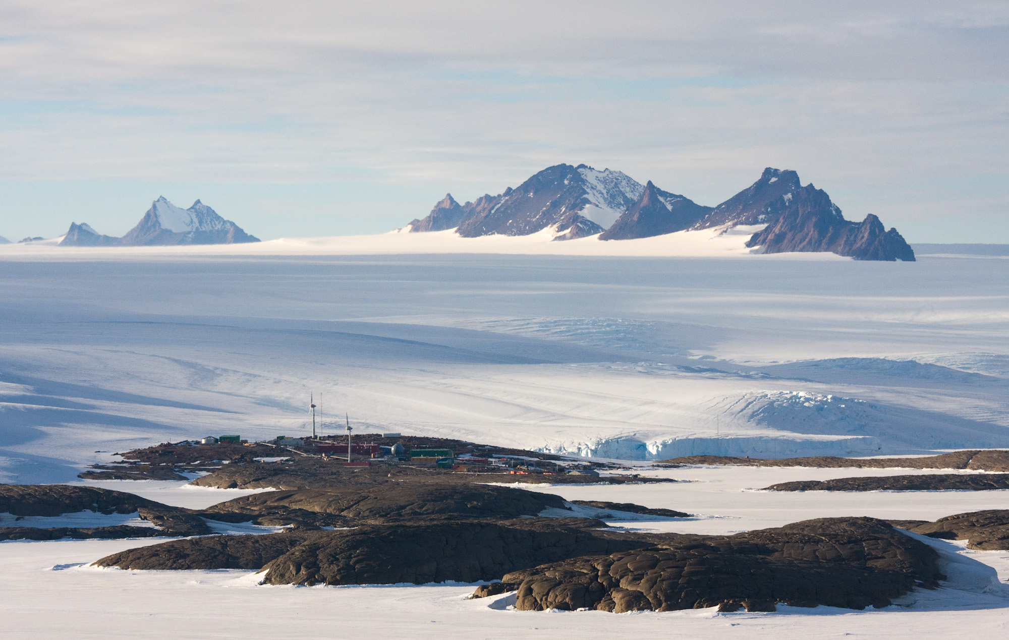
The David Range (67°54′S 62°30′E / 67.900°S 62.500°E is a mountain range that extends for 26 kilometres (16 mi) in the Framnes Mountains of Mac.Robertson Land in Antarctica. The range is surrounded by, and largely covered by, an ice sheet. Only the peaks are visible.
Download coordinates as:
The range was first seen by the British Australian and New Zealand Antarctic Research Expedition (BANZARE) on the evening of 4 January 1930 as a mirage on the horizon. The peaks of the Masson Range and Casey Range were also visible in the mirage. On 14 February 1931 the range was mapped from the Discovery. Sir Douglas Mawson, named the range for Professor Edgeworth David of the BANZARE committee.
The David Range (67°54′S 62°30′E / 67.900°S 62.500°E) is 5 miles (8 km) west of the Masson Range, which it parallels, in the Framnes Mountains of Antarctica. It extends 16 miles (26 km) in a north-northeast–south-southwest direction. The range is about 11 kilometres (6.8 mi) south of Holme Bay. The range lies to the southwest of Mawson Station. The northern tip of the range is nearly 10 kilometres (6.2 mi) due west of the northern tip of the Masson Range. The Brown Range (or Sortindane Peaks) is to the south and the Casey Range to the east. The highest point is the peak of Mount Elliot, at about 1,300 metres (4,300 ft).
According to the 1960 Sailing Directions for Antarctica
The David Range lies parallel to the Masson Range and about 5 miles to the westward. It is a striking rugged mass stretching southward about 15 miles. It is about 3,500 feet high with the highest elevation in Mount Coates, about 4,600 feet high, near the southern end of the ridge. Mount Hordern, about 4,954 feet high, is a conspicuous mountain lying about 5 miles southward of the Coates massif.
The Framnes Mountains have elevations up to 1,500 metres (4,900 ft) above sea level, and rise up to 400 metres (1,300 ft) above the ice surface. They have dark, weathered charnockite bedrock that is littered with light-colored quartz-rich, granitic gneiss glacial erratics. The erratics cover the lower slopes of the David Range and Mount Hordern, but are not found more than about 250 metres (820 ft) above the present-day ice surface. Above this level the darker charnockite bedrock is exposed. Probably the boulders were transported from the south and deposited by ice during the last glacial maximum, while the exposed bedrock would have remained above the ice.
The East Antarctic Ice Sheet (EAIS) formed about 34 million years ago, and seems to have persisted since then with periodic fluctuations in thickness between glacial and inter-glacial cycles. During the last glacial cycle the ice sheet thickened more near the coast, less further inland. This is shown by the upper limit of glacial erratic boulders, ranging from 820 metres (2,690 ft) on Fang Peak near the sea in the north of David Range, to 860 metres (2,820 ft) on Mount Elliot, 1,100 metres (3,600 ft) on Mount Coates and 1,300 metres (4,300 ft) on Mount Hordern, which is about 30 kilometres (19 mi) from the sea. The ice surface appears have lowered by several hundred meters during the present interglacial.
Hub AI
David Range AI simulator
(@David Range_simulator)
David Range
The David Range (67°54′S 62°30′E / 67.900°S 62.500°E is a mountain range that extends for 26 kilometres (16 mi) in the Framnes Mountains of Mac.Robertson Land in Antarctica. The range is surrounded by, and largely covered by, an ice sheet. Only the peaks are visible.
Download coordinates as:
The range was first seen by the British Australian and New Zealand Antarctic Research Expedition (BANZARE) on the evening of 4 January 1930 as a mirage on the horizon. The peaks of the Masson Range and Casey Range were also visible in the mirage. On 14 February 1931 the range was mapped from the Discovery. Sir Douglas Mawson, named the range for Professor Edgeworth David of the BANZARE committee.
The David Range (67°54′S 62°30′E / 67.900°S 62.500°E) is 5 miles (8 km) west of the Masson Range, which it parallels, in the Framnes Mountains of Antarctica. It extends 16 miles (26 km) in a north-northeast–south-southwest direction. The range is about 11 kilometres (6.8 mi) south of Holme Bay. The range lies to the southwest of Mawson Station. The northern tip of the range is nearly 10 kilometres (6.2 mi) due west of the northern tip of the Masson Range. The Brown Range (or Sortindane Peaks) is to the south and the Casey Range to the east. The highest point is the peak of Mount Elliot, at about 1,300 metres (4,300 ft).
According to the 1960 Sailing Directions for Antarctica
The David Range lies parallel to the Masson Range and about 5 miles to the westward. It is a striking rugged mass stretching southward about 15 miles. It is about 3,500 feet high with the highest elevation in Mount Coates, about 4,600 feet high, near the southern end of the ridge. Mount Hordern, about 4,954 feet high, is a conspicuous mountain lying about 5 miles southward of the Coates massif.
The Framnes Mountains have elevations up to 1,500 metres (4,900 ft) above sea level, and rise up to 400 metres (1,300 ft) above the ice surface. They have dark, weathered charnockite bedrock that is littered with light-colored quartz-rich, granitic gneiss glacial erratics. The erratics cover the lower slopes of the David Range and Mount Hordern, but are not found more than about 250 metres (820 ft) above the present-day ice surface. Above this level the darker charnockite bedrock is exposed. Probably the boulders were transported from the south and deposited by ice during the last glacial maximum, while the exposed bedrock would have remained above the ice.
The East Antarctic Ice Sheet (EAIS) formed about 34 million years ago, and seems to have persisted since then with periodic fluctuations in thickness between glacial and inter-glacial cycles. During the last glacial cycle the ice sheet thickened more near the coast, less further inland. This is shown by the upper limit of glacial erratic boulders, ranging from 820 metres (2,690 ft) on Fang Peak near the sea in the north of David Range, to 860 metres (2,820 ft) on Mount Elliot, 1,100 metres (3,600 ft) on Mount Coates and 1,300 metres (4,300 ft) on Mount Hordern, which is about 30 kilometres (19 mi) from the sea. The ice surface appears have lowered by several hundred meters during the present interglacial.
Recent media