Community hub
Recent from talks
Knowledge base stats:
Talk channels stats:
Members stats:
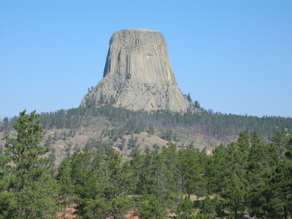
Devils Tower
Devils Tower (also known as Mato Tipila or Bear Lodge) is a laccolithic butte, composed of igneous rock in the Bear Lodge Ranger District of the Black Hills, near Hulett and Sundance in Crook County, northeastern Wyoming, above the Belle Fourche River. It rises 1,267 feet (386 m) above the Belle Fourche River, standing 867 feet (264 m) from summit to base. The summit is 5,112 feet (1,558 m) above sea level.
Devils Tower National Monument was the first United States national monument, established on September 24, 1906, by President Theodore Roosevelt. The monument's boundary encloses an area of 1,347 acres (545 ha).
Indigenous names for the monolith include "Bear's House" or "Bear's Lodge" (or "Bear's Tipi", "Home of the Bear", "Bear's Lair"); Cheyenne, Lakota: Matȟó Thípila, Crow: Daxpitcheeaasáao ("Home of Bears"), "Aloft on a Rock" (Kiowa), "Tree Rock", "Great Gray Horn", and "Brown Buffalo Horn" (Lakota: Ptehé Ǧí).[citation needed]
The name "Devil's Tower" originated in 1875 during an expedition led by Colonel Richard Irving Dodge, when his interpreter reportedly misinterpreted a native name to mean "Bad God's Tower". All information signs in that area use the name "Devils Tower", following a geographic naming standard whereby the apostrophe is omitted.
In 2005, a proposal to recognize several indigenous ties through the additional designation of the monolith as Bear Lodge National Historic Landmark were opposed by United States Representative Barbara Cubin, arguing that a "name change will harm the tourist trade and bring economic hardship to area communities". In November 2014, Arvol Looking Horse proposed renaming the geographical feature "Bear Lodge" and submitted the request to the United States Board on Geographic Names. A second proposal was submitted to request that the U.S. acknowledge what it described as the "offensive" mistake in keeping the current name and to rename the monument and sacred site into Bear Lodge National Historic Landmark. The formal public comment period ended in fall 2015. Local state senator Ogden Driskill opposed the change. The name was not changed.
The landscape surrounding Devils Tower is composed mostly of sedimentary rocks. The oldest rocks visible in Devils Tower National Monument were laid down in a shallow sea during the Triassic. This dark red sandstone and maroon siltstone, interbedded with shale, can be seen along the Belle Fourche River. Oxidation of iron minerals causes the redness of the rocks. This rock layer is known as the Spearfish Formation. Above the Spearfish Formation is a thin band of white gypsum, called the Gypsum Springs Formation, Jurassic in age. Overlying this formation is the Sundance Formation. During the Paleocene Epoch, 56 to 66 million years ago, the Rocky Mountains and the Black Hills were uplifted. Magma rose through the crust, intruding into the existing sedimentary rock layers.
Geologists Carpenter and Russell studied Devils Tower in the late 19th century and came to the conclusion that it was formed by an igneous intrusion. In 1907, geologists Nelson Horatio Darton and C.C. O'Harra (of the South Dakota School of Mines) theorized that Devils Tower must be an eroded remnant of a laccolith.
The igneous material that forms the Tower is a phonolite porphyry intruded about 40.5 million years ago, a light to dark-gray or greenish-gray igneous rock with conspicuous crystals of white feldspar. As the magma cooled, hexagonal columns formed (though sometimes 4-, 5-, and 7-sided columns were possible), up to 20 feet (6.1 m) wide and 600 feet (180 m) tall.
Hub AI
Devils Tower AI simulator
(@Devils Tower_simulator)
Devils Tower
Devils Tower (also known as Mato Tipila or Bear Lodge) is a laccolithic butte, composed of igneous rock in the Bear Lodge Ranger District of the Black Hills, near Hulett and Sundance in Crook County, northeastern Wyoming, above the Belle Fourche River. It rises 1,267 feet (386 m) above the Belle Fourche River, standing 867 feet (264 m) from summit to base. The summit is 5,112 feet (1,558 m) above sea level.
Devils Tower National Monument was the first United States national monument, established on September 24, 1906, by President Theodore Roosevelt. The monument's boundary encloses an area of 1,347 acres (545 ha).
Indigenous names for the monolith include "Bear's House" or "Bear's Lodge" (or "Bear's Tipi", "Home of the Bear", "Bear's Lair"); Cheyenne, Lakota: Matȟó Thípila, Crow: Daxpitcheeaasáao ("Home of Bears"), "Aloft on a Rock" (Kiowa), "Tree Rock", "Great Gray Horn", and "Brown Buffalo Horn" (Lakota: Ptehé Ǧí).[citation needed]
The name "Devil's Tower" originated in 1875 during an expedition led by Colonel Richard Irving Dodge, when his interpreter reportedly misinterpreted a native name to mean "Bad God's Tower". All information signs in that area use the name "Devils Tower", following a geographic naming standard whereby the apostrophe is omitted.
In 2005, a proposal to recognize several indigenous ties through the additional designation of the monolith as Bear Lodge National Historic Landmark were opposed by United States Representative Barbara Cubin, arguing that a "name change will harm the tourist trade and bring economic hardship to area communities". In November 2014, Arvol Looking Horse proposed renaming the geographical feature "Bear Lodge" and submitted the request to the United States Board on Geographic Names. A second proposal was submitted to request that the U.S. acknowledge what it described as the "offensive" mistake in keeping the current name and to rename the monument and sacred site into Bear Lodge National Historic Landmark. The formal public comment period ended in fall 2015. Local state senator Ogden Driskill opposed the change. The name was not changed.
The landscape surrounding Devils Tower is composed mostly of sedimentary rocks. The oldest rocks visible in Devils Tower National Monument were laid down in a shallow sea during the Triassic. This dark red sandstone and maroon siltstone, interbedded with shale, can be seen along the Belle Fourche River. Oxidation of iron minerals causes the redness of the rocks. This rock layer is known as the Spearfish Formation. Above the Spearfish Formation is a thin band of white gypsum, called the Gypsum Springs Formation, Jurassic in age. Overlying this formation is the Sundance Formation. During the Paleocene Epoch, 56 to 66 million years ago, the Rocky Mountains and the Black Hills were uplifted. Magma rose through the crust, intruding into the existing sedimentary rock layers.
Geologists Carpenter and Russell studied Devils Tower in the late 19th century and came to the conclusion that it was formed by an igneous intrusion. In 1907, geologists Nelson Horatio Darton and C.C. O'Harra (of the South Dakota School of Mines) theorized that Devils Tower must be an eroded remnant of a laccolith.
The igneous material that forms the Tower is a phonolite porphyry intruded about 40.5 million years ago, a light to dark-gray or greenish-gray igneous rock with conspicuous crystals of white feldspar. As the magma cooled, hexagonal columns formed (though sometimes 4-, 5-, and 7-sided columns were possible), up to 20 feet (6.1 m) wide and 600 feet (180 m) tall.