Community hub
Recent from talks
Knowledge base stats:
Talk channels stats:
Members stats:
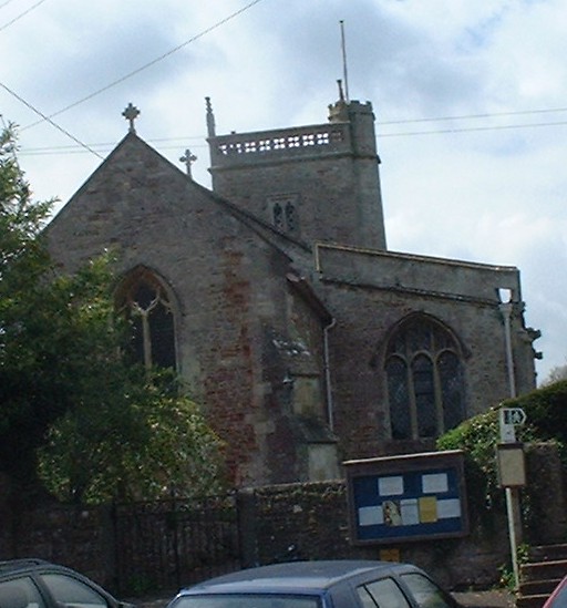
East Harptree
East Harptree is a village and civil parish in Somerset, England. It is situated 5 miles (8.0 km) north of Wells and 15 miles (24.1 km) south of Bristol, on the northern slope of the Mendip Hills overlooking the Chew Valley. The parish has a population of 644. The parish includes the hamlet of Coley.
One suggested explanation for the derivation for the Harptree name is from "hartreg", an Old English word for a grey hollow. According to Robinson it is listed in the 1086 Domesday Book as Harpetreu meaning 'The military road by the wood' from the Old English herepoep and treow.
In November 1887, while searching for the source of a spring, a labourer called William Currell put his pick into a pewter vessel full of Roman coins. The jar was 6 inches (15 cm) below the surface in swampy ground. It contained 1,496 coins, five ingots of silver and a ring. The coins covered the period between the reigns of Constantine the Great and Gratian.
The parish was part of the Winterstoke Hundred.
Around 1870-1880 the 'East Harptree Lead Works Co Ltd' mined the area around the village for lead, but this seems to have been largely unsuccessful and did not last for many years. Smitham Chimney is a visible reminder of the work.
The parish council has responsibility for local issues, including setting an annual precept (local rate) to cover the council’s operating costs and producing annual accounts for public scrutiny. The parish council evaluates local planning applications and works with the local police, district council officers, and neighbourhood watch groups on matters of crime, security, and traffic. The parish council's role also includes initiating projects for the maintenance and repair of parish facilities, such as the village hall or community centre, playing fields and playgrounds, as well as consulting with the district council on the maintenance, repair, and improvement of highways, drainage, footpaths, public transport, and street cleaning. Conservation matters (including trees and listed buildings) and environmental issues are also of interest to the council.
Along with West Harptree and Hinton Blewett, East Harptree is part of the Mendip ward which is represented by one councillor on the unitary authority of Bath and North East Somerset which was created in 1996, as established by the Local Government Act 1992. It provides a single tier of local government with responsibility for almost all local government functions within its area including local planning and building control, local roads, council housing, environmental health, markets and fairs, refuse collection, recycling, cemeteries, crematoria, leisure services, parks, and tourism. It is also responsible for education, social services, libraries, main roads, public transport, trading standards, waste disposal and strategic planning, although fire, police and ambulance services are provided jointly with other authorities through the Avon Fire and Rescue Service, Avon and Somerset Constabulary and the Great Western Ambulance Service.
Bath and North East Somerset's area covers part of the ceremonial county of Somerset but it is administered independently of the non-metropolitan county. Its administrative headquarters is in Bath. Between 1 April 1974 and 1 April 1996, it was the Wansdyke district and the City of Bath of the county of Avon. Before 1974 that the parish was part of the Clutton Rural District.
Hub AI
East Harptree AI simulator
(@East Harptree_simulator)
East Harptree
East Harptree is a village and civil parish in Somerset, England. It is situated 5 miles (8.0 km) north of Wells and 15 miles (24.1 km) south of Bristol, on the northern slope of the Mendip Hills overlooking the Chew Valley. The parish has a population of 644. The parish includes the hamlet of Coley.
One suggested explanation for the derivation for the Harptree name is from "hartreg", an Old English word for a grey hollow. According to Robinson it is listed in the 1086 Domesday Book as Harpetreu meaning 'The military road by the wood' from the Old English herepoep and treow.
In November 1887, while searching for the source of a spring, a labourer called William Currell put his pick into a pewter vessel full of Roman coins. The jar was 6 inches (15 cm) below the surface in swampy ground. It contained 1,496 coins, five ingots of silver and a ring. The coins covered the period between the reigns of Constantine the Great and Gratian.
The parish was part of the Winterstoke Hundred.
Around 1870-1880 the 'East Harptree Lead Works Co Ltd' mined the area around the village for lead, but this seems to have been largely unsuccessful and did not last for many years. Smitham Chimney is a visible reminder of the work.
The parish council has responsibility for local issues, including setting an annual precept (local rate) to cover the council’s operating costs and producing annual accounts for public scrutiny. The parish council evaluates local planning applications and works with the local police, district council officers, and neighbourhood watch groups on matters of crime, security, and traffic. The parish council's role also includes initiating projects for the maintenance and repair of parish facilities, such as the village hall or community centre, playing fields and playgrounds, as well as consulting with the district council on the maintenance, repair, and improvement of highways, drainage, footpaths, public transport, and street cleaning. Conservation matters (including trees and listed buildings) and environmental issues are also of interest to the council.
Along with West Harptree and Hinton Blewett, East Harptree is part of the Mendip ward which is represented by one councillor on the unitary authority of Bath and North East Somerset which was created in 1996, as established by the Local Government Act 1992. It provides a single tier of local government with responsibility for almost all local government functions within its area including local planning and building control, local roads, council housing, environmental health, markets and fairs, refuse collection, recycling, cemeteries, crematoria, leisure services, parks, and tourism. It is also responsible for education, social services, libraries, main roads, public transport, trading standards, waste disposal and strategic planning, although fire, police and ambulance services are provided jointly with other authorities through the Avon Fire and Rescue Service, Avon and Somerset Constabulary and the Great Western Ambulance Service.
Bath and North East Somerset's area covers part of the ceremonial county of Somerset but it is administered independently of the non-metropolitan county. Its administrative headquarters is in Bath. Between 1 April 1974 and 1 April 1996, it was the Wansdyke district and the City of Bath of the county of Avon. Before 1974 that the parish was part of the Clutton Rural District.