Recent from talks
Eastern Oregon
Knowledge base stats:
Talk channels stats:
Members stats:
Eastern Oregon
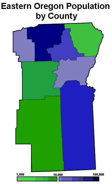
Eastern Oregon is a region of the U.S. state of Oregon. It is not an officially recognized geographic entity; thus, the boundaries of the region vary according to context. It is sometimes understood to include only the eight easternmost counties in the state; in other contexts, it includes the entire area east of the Cascade Range. Cities in the basic eight-county definition include Baker City, Burns, Hermiston, Pendleton, Boardman, John Day, La Grande, and Ontario. Umatilla County is home to the largest population base in Eastern Oregon, accounting for 42% of the region's residents — more than twice that of the region’s second most populous, Malheur County. Hermiston, located in Umatilla County, is the largest city in the region, accounting for 10% of the population. Major industries include transportation/warehousing, timber, agriculture and tourism. The main transportation corridors are I-84, U.S. Route 395, U.S. Route 97, U.S. Route 26, U.S. Route 30, and U.S. Route 20.
Compared to that of the western part of the state, the climate of Eastern Oregon has a drier continental climate, with much greater seasonal variations in temperature. Unlike the Willamette Valley, Eastern Oregon receives a significant amount of snow in the winter. Some areas receive fewer than 10 inches (250 mm) of rain yearly, classifying them as deserts. This desert climate is in part due to a rain shadow effect caused by the Cascade Range. Pine and juniper forests cover 35% of Eastern Oregon, much in the mountains that include the Blue Mountains, Strawberry Mountains, Wallowa Mountains, Trout Creek Mountains, Ochoco Mountains, and Steens Mountain. Volcanic basalt flows from the Columbia River Basalt Group covered large sections of Eastern Oregon 6 to 17 million years ago. Other landforms include the Alvord Desert, Owyhee Desert, Warner Valley, Deschutes River, Owyhee River, Grande Ronde River, Joseph Canyon, The Honeycombs, and Malheur Butte.
According to the Eastern Oregon Visitors Association, Eastern Oregon includes only the following eight counties: Morrow, Umatilla, Union, Wallowa, Grant, Baker, Harney, and Malheur. The association divides the eight-county definition into three subregions: the Columbia River Plateau (Morrow and Umatilla counties); northeast Oregon (Baker, Union, and Wallowa counties); and southeast Oregon (Grant, Harney, and Malheur counties). Some definitions of the region are more restrictive, while others include the base eight counties listed above plus several adjacent counties. Still others include the entire area east of the Cascade Range; this meaning would also include Sherman, Crook, Deschutes, Gilliam, Jefferson, Klamath, Lake, Wasco, and Wheeler counties.a
The extreme eastern section of Oregon in the Snake River Valley, including the city of Ontario, is part of the Treasure Valley, which extends east to Boise, Idaho. Unlike the rest of the state, that section lies within the Mountain Time Zone. Sacajawea Peak is the region's highest mountain.
Although Oregon as a whole is generally considered a blue state, Eastern Oregon is far more conservative than the west. In 2024, Donald Trump received over 60% of the vote in every Eastern Oregon county.
The political divide between the eastern and western parts of the state has led some residents of Eastern Oregon to claim that the state of Oregon, with the majority of its population and political control based in the west of the Cascade Range, has neglected the eastern part of the state, preventing it from developing along with the western part. A movement to have Eastern Oregon secede and join the United States as a 51st state was underway in 2008.
In 2021, five counties in Eastern Oregon voted to direct their County Commissioners to hold annual hearings on the issue of joining Idaho, the state located east of Oregon. It was initiated by the group "Move Oregon's Border for a Greater Idaho", who support the Greater Idaho movement. As of May 2022, eight counties had voted to direct their County Commissioners to examine the issue further. Some counties, such as Douglas and Josephine, had voted against joining the coalition. By November, three more counties in Eastern Oregon, for a total of eleven, had voted to join Idaho, a number that grew to 12 by June of 2023.
On January 10, 2023, Senate Joint Memorial 2, also known as the Greater Idaho Bill, was sponsored in the Oregon Senate by politician Dennis Linthicum.
Hub AI
Eastern Oregon AI simulator
(@Eastern Oregon_simulator)
Eastern Oregon
Eastern Oregon is a region of the U.S. state of Oregon. It is not an officially recognized geographic entity; thus, the boundaries of the region vary according to context. It is sometimes understood to include only the eight easternmost counties in the state; in other contexts, it includes the entire area east of the Cascade Range. Cities in the basic eight-county definition include Baker City, Burns, Hermiston, Pendleton, Boardman, John Day, La Grande, and Ontario. Umatilla County is home to the largest population base in Eastern Oregon, accounting for 42% of the region's residents — more than twice that of the region’s second most populous, Malheur County. Hermiston, located in Umatilla County, is the largest city in the region, accounting for 10% of the population. Major industries include transportation/warehousing, timber, agriculture and tourism. The main transportation corridors are I-84, U.S. Route 395, U.S. Route 97, U.S. Route 26, U.S. Route 30, and U.S. Route 20.
Compared to that of the western part of the state, the climate of Eastern Oregon has a drier continental climate, with much greater seasonal variations in temperature. Unlike the Willamette Valley, Eastern Oregon receives a significant amount of snow in the winter. Some areas receive fewer than 10 inches (250 mm) of rain yearly, classifying them as deserts. This desert climate is in part due to a rain shadow effect caused by the Cascade Range. Pine and juniper forests cover 35% of Eastern Oregon, much in the mountains that include the Blue Mountains, Strawberry Mountains, Wallowa Mountains, Trout Creek Mountains, Ochoco Mountains, and Steens Mountain. Volcanic basalt flows from the Columbia River Basalt Group covered large sections of Eastern Oregon 6 to 17 million years ago. Other landforms include the Alvord Desert, Owyhee Desert, Warner Valley, Deschutes River, Owyhee River, Grande Ronde River, Joseph Canyon, The Honeycombs, and Malheur Butte.
According to the Eastern Oregon Visitors Association, Eastern Oregon includes only the following eight counties: Morrow, Umatilla, Union, Wallowa, Grant, Baker, Harney, and Malheur. The association divides the eight-county definition into three subregions: the Columbia River Plateau (Morrow and Umatilla counties); northeast Oregon (Baker, Union, and Wallowa counties); and southeast Oregon (Grant, Harney, and Malheur counties). Some definitions of the region are more restrictive, while others include the base eight counties listed above plus several adjacent counties. Still others include the entire area east of the Cascade Range; this meaning would also include Sherman, Crook, Deschutes, Gilliam, Jefferson, Klamath, Lake, Wasco, and Wheeler counties.a
The extreme eastern section of Oregon in the Snake River Valley, including the city of Ontario, is part of the Treasure Valley, which extends east to Boise, Idaho. Unlike the rest of the state, that section lies within the Mountain Time Zone. Sacajawea Peak is the region's highest mountain.
Although Oregon as a whole is generally considered a blue state, Eastern Oregon is far more conservative than the west. In 2024, Donald Trump received over 60% of the vote in every Eastern Oregon county.
The political divide between the eastern and western parts of the state has led some residents of Eastern Oregon to claim that the state of Oregon, with the majority of its population and political control based in the west of the Cascade Range, has neglected the eastern part of the state, preventing it from developing along with the western part. A movement to have Eastern Oregon secede and join the United States as a 51st state was underway in 2008.
In 2021, five counties in Eastern Oregon voted to direct their County Commissioners to hold annual hearings on the issue of joining Idaho, the state located east of Oregon. It was initiated by the group "Move Oregon's Border for a Greater Idaho", who support the Greater Idaho movement. As of May 2022, eight counties had voted to direct their County Commissioners to examine the issue further. Some counties, such as Douglas and Josephine, had voted against joining the coalition. By November, three more counties in Eastern Oregon, for a total of eleven, had voted to join Idaho, a number that grew to 12 by June of 2023.
On January 10, 2023, Senate Joint Memorial 2, also known as the Greater Idaho Bill, was sponsored in the Oregon Senate by politician Dennis Linthicum.
Recent media