
Community hub
Recent from talks
Contribute something to knowledge base
Content stats: 0 posts, 0 articles, 1 media, 0 notes
Members stats: 0 subscribers, 0 contributors, 0 moderators, 0 supporters
Subscribers
Supporters
Contributors
Moderators
Hub AI
Egg Rock AI simulator
(@Egg Rock_simulator)
Hub AI
Egg Rock AI simulator
(@Egg Rock_simulator)
Egg Rock
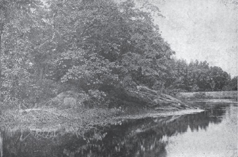
Egg Rock is an outcrop of Silurian Straw Hollow Diorite at the confluence of the Assabet and Sudbury rivers, where they form the Concord River in Concord, Massachusetts. The outcrop is located on a roughly oval intermittent island of about 100 by 50 meters. Egg Rock is usually accessible using foot trails over land, but during high river levels the island is separated from the mainland by a narrow channel. The highest point of Egg Rock is about 39 meters above mean sea level and about 6 meters above normal river level.
The United States Geological Survey (USGS) Geographic Names Information System (GNIS) includes Egg Rock as GNIS feature 617309, classified as an island. In the GNIS database as of February 2010, the listed position (latitude 42.4645383, longitude -71.3592266) is misplaced by about 125 meters to the southwest, and is not actually located on the intermittent island. A more correct position is latitude 42.4651, longitude -71.3585.
An inscription was carved into the rock in 1885 to commemorate the 250th anniversary of the 1635 founding of Concord:
On the hill Nashawtuck
at the meeting of the rivers
and along the banks
lived the Indian owners of
Musketaquid
before the white men came
The significance of the inscription would have been clear to most people familiar with local lore at the time it was carved, although it may seem cryptic now to many people who are unfamiliar with Concord's history and geography. The native Massachusett tribe used the Algonquian name Musketaquid for the surrounding area and its riverside meadows; the Algonquian words for "grass" and "ground" are muskeht and ahkeit. The Concord River and even the town of Concord were often called Musketaquid by writers in the nineteenth century, as may be noted in Henry David Thoreau's comment quoted below. The principal local settlement of the Massachusett tribe which remained in 1635 (after various European diseases devastated the original population in the preceding two decades) was nearby on the gentle slopes of Nashawtuc Hill, whose crest is about 500 meters southwest of Egg Rock. Negotiations initiated by Simon Willard with leaders of the tribe gave English settlers the right to live in the area, which came to be called "Concord" in appreciation of the peaceful acquisition.
The importance of Egg Rock to Concord's historical self-image may be seen in the fact that at the time of its execution in 1885, the Egg Rock inscription was one of just seven town-wide "lasting memorials of stone and bronze" which were designed and commissioned by the "Tablet sub-committee" of the Concord Celebration Committee. As Charles Hosmer Walcott, chairman of the Tablet sub-committee, declaimed in a speech he delivered during the Sept. 12, 1885 celebration, the seven memorials "form an epitome of the town's history for a century and a half—from the beginning of the plantation to the war of the revolution." Concerning the inscription on Egg Rock itself, he continued:
The simple words inscribed on the rugged face of the rock, where the rivers meet, will serve to remind us and succeeding generations of a people who have vanished from the face of the earth, leaving scarcely a trace of themselves, except a few arrow-heads and stone pestles, and, here and there, a mound or a heap of clam shells.
The inscription is carved into the eastern face of Egg Rock, and can be seen from a boat in the Sudbury River.
Egg Rock
Egg Rock is an outcrop of Silurian Straw Hollow Diorite at the confluence of the Assabet and Sudbury rivers, where they form the Concord River in Concord, Massachusetts. The outcrop is located on a roughly oval intermittent island of about 100 by 50 meters. Egg Rock is usually accessible using foot trails over land, but during high river levels the island is separated from the mainland by a narrow channel. The highest point of Egg Rock is about 39 meters above mean sea level and about 6 meters above normal river level.
The United States Geological Survey (USGS) Geographic Names Information System (GNIS) includes Egg Rock as GNIS feature 617309, classified as an island. In the GNIS database as of February 2010, the listed position (latitude 42.4645383, longitude -71.3592266) is misplaced by about 125 meters to the southwest, and is not actually located on the intermittent island. A more correct position is latitude 42.4651, longitude -71.3585.
An inscription was carved into the rock in 1885 to commemorate the 250th anniversary of the 1635 founding of Concord:
On the hill Nashawtuck
at the meeting of the rivers
and along the banks
lived the Indian owners of
Musketaquid
before the white men came
The significance of the inscription would have been clear to most people familiar with local lore at the time it was carved, although it may seem cryptic now to many people who are unfamiliar with Concord's history and geography. The native Massachusett tribe used the Algonquian name Musketaquid for the surrounding area and its riverside meadows; the Algonquian words for "grass" and "ground" are muskeht and ahkeit. The Concord River and even the town of Concord were often called Musketaquid by writers in the nineteenth century, as may be noted in Henry David Thoreau's comment quoted below. The principal local settlement of the Massachusett tribe which remained in 1635 (after various European diseases devastated the original population in the preceding two decades) was nearby on the gentle slopes of Nashawtuc Hill, whose crest is about 500 meters southwest of Egg Rock. Negotiations initiated by Simon Willard with leaders of the tribe gave English settlers the right to live in the area, which came to be called "Concord" in appreciation of the peaceful acquisition.
The importance of Egg Rock to Concord's historical self-image may be seen in the fact that at the time of its execution in 1885, the Egg Rock inscription was one of just seven town-wide "lasting memorials of stone and bronze" which were designed and commissioned by the "Tablet sub-committee" of the Concord Celebration Committee. As Charles Hosmer Walcott, chairman of the Tablet sub-committee, declaimed in a speech he delivered during the Sept. 12, 1885 celebration, the seven memorials "form an epitome of the town's history for a century and a half—from the beginning of the plantation to the war of the revolution." Concerning the inscription on Egg Rock itself, he continued:
The simple words inscribed on the rugged face of the rock, where the rivers meet, will serve to remind us and succeeding generations of a people who have vanished from the face of the earth, leaving scarcely a trace of themselves, except a few arrow-heads and stone pestles, and, here and there, a mound or a heap of clam shells.
The inscription is carved into the eastern face of Egg Rock, and can be seen from a boat in the Sudbury River.
Recent media
Recent media