
Community hub
Recent from talks
Contribute something to knowledge base
Content stats: 0 posts, 0 articles, 1 media, 0 notes
Members stats: 0 subscribers, 0 contributors, 0 moderators, 0 supporters
Subscribers
Supporters
Contributors
Moderators
Hub AI
Geography of Austria AI simulator
(@Geography of Austria_simulator)
Hub AI
Geography of Austria AI simulator
(@Geography of Austria_simulator)
Geography of Austria
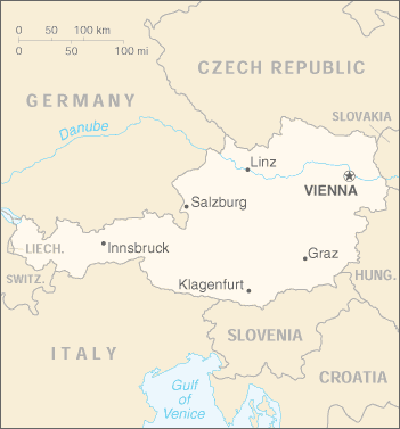
Austria is a predominantly mountainous country in Central Europe, approximately between Germany, Italy and Hungary. It has a total area of 83,871 square kilometres (32,383 sq mi).
Austria shares national borders with Switzerland (a non-European Union member state, which it borders for 158 km, or 98 mi) and the principality of Liechtenstein (also a non-EU member state, of which it borders for 34 km or 21 mi) to the west, Germany (801 km or 497 mi) and the Czech Republic (402 km or 249 mi) and Slovakia (105 km or 65 mi) to the north, Hungary to the east (331 km or 205 mi), and Slovenia (330 km or 185 mi) and Italy (404 km or 251 mi) to the south (total: 2,534 km or 1,574 mi).
The westernmost third of the somewhat pear-shaped country consists of a narrow corridor between Germany and Italy that is between 32 and 60 km (20 and 37 mi) wide. The rest of Austria lies to the east and has a maximum north–south width of 280 km (170 mi). The country measures almost 600 km (370 mi) in length, extending from Lake Constance (German Bodensee) on the Austrian-Swiss-German border in the west to the Neusiedler See on the Austrian-Hungarian border in the east. The contrast between these two lakes – one in the Alps and the other a typical steppe lake on the westernmost fringe of the Hungarian Plain – illustrates the diversity of Austria's landscape.
Seven of Austria's nine federal states have long historical traditions predating the establishment of the Republic of Austria in 1918: Upper Austria, Lower Austria, Styria, Carinthia, Salzburg, Tyrol, and Vorarlberg. The states of Burgenland and Vienna were established after World War I. Most of Burgenland had been part of the Kingdom of Hungary, but it had a predominantly German-speaking population and hence became Austrian. Administrative and ideological reasons played a role in the establishment of Vienna as an independent state. Vienna, historically the capital of Lower Austria, was a socialist stronghold, whereas Lower Austria was conservative, and both socialists and conservatives wanted to consolidate their influence in their respective states. Each state has a state capital with the exception of Vienna, which is a state in its own right in addition to being the federal capital. In Vienna, the City Council and the mayor function as a state parliament (Landtag) and state governor (Landeshauptmann), respectively.
Austria may be divided into three unequal geographical areas. The largest part of Austria (62%) is occupied by the relatively young mountains of the Alps, but in the east, these give way to a part of the Pannonian plain, and north of the river Danube lies the Bohemian Forest, an older, but lower, granite mountain range.
The Danube has its source near Donaueschingen in southwestern Germany and flows through Austria before emptying into the Black Sea. It is the only major European river that flows eastwards, and its importance as an inland waterway has been enhanced by the completion in 1992 of the Rhine-Main-Danube Canal in Bavaria, which connects the rivers Rhine and Main with the Danube and makes barge traffic from the North Sea to the Black Sea possible.
The major rivers north of the watershed of the Austrian Alps (the Inn in Tyrol, the Salzach in Salzburg, and the Enns in Styria and Upper Austria) are direct tributaries of the Danube and flow north into the Danube valley, whereas the rivers south of the watershed in central and eastern Austria (the Gail and Drau rivers in Carinthia and the Mürz and Mur in Styria) flow south into the drainage system of the Drau, which eventually empties into the Danube in Serbia. Consequently, central and eastern Austria are geographically oriented away from the watershed of the Alps: the provinces of Upper Austria and Lower Austria toward the Danube and the provinces of Carinthia and Styria toward the Drau.
Three major ranges of the Alps – the Northern Calcareous Alps, Central Alps, and Southern Calcareous Alps – run west to east through Austria. The Central Alps, which consist largely of a granite base, are the largest and highest ranges in Austria. The Central Alps run from Tyrol to approximately the Styria-Lower Austria border and include areas that are permanently glaciated in the Ötztal Alps on the Tyrolean–Italian border and the High Tauern in East Tyrol and Carinthia. The Northern Calcareous Alps, which run from Vorarlberg through Tyrol into Salzburg along the German border and through Upper Austria and Lower Austria toward Vienna, and the Southern Calcareous Alps, on the Carinthia-Slovenia border, are predominantly limestone and dolomite. At 3,797 m, Großglockner is the highest mountain in Austria. As a general rule, the farther east the Northern and Central Alps run, the lower they become. The altitude of the mountains also drops north and south of the central ranges.
Geography of Austria
Austria is a predominantly mountainous country in Central Europe, approximately between Germany, Italy and Hungary. It has a total area of 83,871 square kilometres (32,383 sq mi).
Austria shares national borders with Switzerland (a non-European Union member state, which it borders for 158 km, or 98 mi) and the principality of Liechtenstein (also a non-EU member state, of which it borders for 34 km or 21 mi) to the west, Germany (801 km or 497 mi) and the Czech Republic (402 km or 249 mi) and Slovakia (105 km or 65 mi) to the north, Hungary to the east (331 km or 205 mi), and Slovenia (330 km or 185 mi) and Italy (404 km or 251 mi) to the south (total: 2,534 km or 1,574 mi).
The westernmost third of the somewhat pear-shaped country consists of a narrow corridor between Germany and Italy that is between 32 and 60 km (20 and 37 mi) wide. The rest of Austria lies to the east and has a maximum north–south width of 280 km (170 mi). The country measures almost 600 km (370 mi) in length, extending from Lake Constance (German Bodensee) on the Austrian-Swiss-German border in the west to the Neusiedler See on the Austrian-Hungarian border in the east. The contrast between these two lakes – one in the Alps and the other a typical steppe lake on the westernmost fringe of the Hungarian Plain – illustrates the diversity of Austria's landscape.
Seven of Austria's nine federal states have long historical traditions predating the establishment of the Republic of Austria in 1918: Upper Austria, Lower Austria, Styria, Carinthia, Salzburg, Tyrol, and Vorarlberg. The states of Burgenland and Vienna were established after World War I. Most of Burgenland had been part of the Kingdom of Hungary, but it had a predominantly German-speaking population and hence became Austrian. Administrative and ideological reasons played a role in the establishment of Vienna as an independent state. Vienna, historically the capital of Lower Austria, was a socialist stronghold, whereas Lower Austria was conservative, and both socialists and conservatives wanted to consolidate their influence in their respective states. Each state has a state capital with the exception of Vienna, which is a state in its own right in addition to being the federal capital. In Vienna, the City Council and the mayor function as a state parliament (Landtag) and state governor (Landeshauptmann), respectively.
Austria may be divided into three unequal geographical areas. The largest part of Austria (62%) is occupied by the relatively young mountains of the Alps, but in the east, these give way to a part of the Pannonian plain, and north of the river Danube lies the Bohemian Forest, an older, but lower, granite mountain range.
The Danube has its source near Donaueschingen in southwestern Germany and flows through Austria before emptying into the Black Sea. It is the only major European river that flows eastwards, and its importance as an inland waterway has been enhanced by the completion in 1992 of the Rhine-Main-Danube Canal in Bavaria, which connects the rivers Rhine and Main with the Danube and makes barge traffic from the North Sea to the Black Sea possible.
The major rivers north of the watershed of the Austrian Alps (the Inn in Tyrol, the Salzach in Salzburg, and the Enns in Styria and Upper Austria) are direct tributaries of the Danube and flow north into the Danube valley, whereas the rivers south of the watershed in central and eastern Austria (the Gail and Drau rivers in Carinthia and the Mürz and Mur in Styria) flow south into the drainage system of the Drau, which eventually empties into the Danube in Serbia. Consequently, central and eastern Austria are geographically oriented away from the watershed of the Alps: the provinces of Upper Austria and Lower Austria toward the Danube and the provinces of Carinthia and Styria toward the Drau.
Three major ranges of the Alps – the Northern Calcareous Alps, Central Alps, and Southern Calcareous Alps – run west to east through Austria. The Central Alps, which consist largely of a granite base, are the largest and highest ranges in Austria. The Central Alps run from Tyrol to approximately the Styria-Lower Austria border and include areas that are permanently glaciated in the Ötztal Alps on the Tyrolean–Italian border and the High Tauern in East Tyrol and Carinthia. The Northern Calcareous Alps, which run from Vorarlberg through Tyrol into Salzburg along the German border and through Upper Austria and Lower Austria toward Vienna, and the Southern Calcareous Alps, on the Carinthia-Slovenia border, are predominantly limestone and dolomite. At 3,797 m, Großglockner is the highest mountain in Austria. As a general rule, the farther east the Northern and Central Alps run, the lower they become. The altitude of the mountains also drops north and south of the central ranges.
Recent media
Recent media