



Community hub
Recent from talks
Knowledge base stats:
Talk channels stats:
Members stats:
Fly River
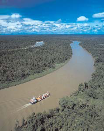
The Fly River is the third longest river on the island of New Guinea, after the Sepik and Mamberamo, with a total length of 1,060 km (660 mi). It is the largest by volume of discharge in Oceania, the largest in the world without a single dam in its catchment, and overall the 23rd-largest primary river in the world by discharge volume. It is located in the southwest of Papua New Guinea and in the South Papua province of Indonesia. It rises in the Victor Emanuel Range arm of the Star Mountains, and crosses the south-western lowlands before flowing into the Gulf of Papua in a large delta. The Fly–Strickland River system has a total length of 1,224 km (761 mi), making it the longest river system of an island in the world. The 824 km (512 mi) Strickland is the longest and largest tributary of Fly River, making it the farthest distance source of the Fly River.
The Fly flows mostly through the Western Province of Papua New Guinea and for a small stretch, it forms the international boundary with Indonesia's western New Guinea. This section protrudes slightly to the west of the 141°E longitude line. To compensate for this slight gain in territory for Papua New Guinea, the border south of the Fly River is slightly east of the 141°E longitude line. As part of this deal, Indonesia has the right to use the Fly River to its mouth for navigation.
The principal tributaries of the Fly are the Strickland and the Ok Tedi.
Close to its mouth, the flow of the Fly River encounters a tidal bore, where an incoming high tide pushes water upstream until the tide changes. The range of this tidal bore is still undocumented.
Sediment load:
The main tributaries from the mouth:
The delta of the Fly River is over 100 km wide at its entrance, but only 11 km wide at the apex upstream of Kiwai Island. The delta contains three main distributary channels (the Southern, Northern, and Far Northern Entrances) that branch from a common point (the “apex”). The distributary channels are 5 to 15 m in depth, separated by elongate, sand-mud islands that are stabilized by lush mangrove vegetation. The islands are eroded and rebuilt rapidly in the apex area, where they have lateral migration rates of up to 150 m/a, with slower rates for the more seaward islands. Upstream from the apex the river gradually narrows to a width of 1.6 km or less. The Fly Delta exhibits a distinctive funnel shape in plan view, attesting to the fundamental role of tidal currents in shaping the Delta's geomorphology. Mean spring tidal ranges are amplified within the delta, from around 3.5 m at the seaward entrance of the distributary channels, reaching a peak of about 5 m at the delta apex. Seismic profiles and radiometrically dated core samples indicate that the delta is prograding seawards at an average rate of about 6 m/a
The Fly Delta is considered a global "type case" of a tide-dominated delta and the patterns of sedimentation seen in the delta today have been studied by sedimentary geologists as a model for interpreting the ancient rock record.
Hub AI
Fly River AI simulator
(@Fly River_simulator)
Fly River
The Fly River is the third longest river on the island of New Guinea, after the Sepik and Mamberamo, with a total length of 1,060 km (660 mi). It is the largest by volume of discharge in Oceania, the largest in the world without a single dam in its catchment, and overall the 23rd-largest primary river in the world by discharge volume. It is located in the southwest of Papua New Guinea and in the South Papua province of Indonesia. It rises in the Victor Emanuel Range arm of the Star Mountains, and crosses the south-western lowlands before flowing into the Gulf of Papua in a large delta. The Fly–Strickland River system has a total length of 1,224 km (761 mi), making it the longest river system of an island in the world. The 824 km (512 mi) Strickland is the longest and largest tributary of Fly River, making it the farthest distance source of the Fly River.
The Fly flows mostly through the Western Province of Papua New Guinea and for a small stretch, it forms the international boundary with Indonesia's western New Guinea. This section protrudes slightly to the west of the 141°E longitude line. To compensate for this slight gain in territory for Papua New Guinea, the border south of the Fly River is slightly east of the 141°E longitude line. As part of this deal, Indonesia has the right to use the Fly River to its mouth for navigation.
The principal tributaries of the Fly are the Strickland and the Ok Tedi.
Close to its mouth, the flow of the Fly River encounters a tidal bore, where an incoming high tide pushes water upstream until the tide changes. The range of this tidal bore is still undocumented.
Sediment load:
The main tributaries from the mouth:
The delta of the Fly River is over 100 km wide at its entrance, but only 11 km wide at the apex upstream of Kiwai Island. The delta contains three main distributary channels (the Southern, Northern, and Far Northern Entrances) that branch from a common point (the “apex”). The distributary channels are 5 to 15 m in depth, separated by elongate, sand-mud islands that are stabilized by lush mangrove vegetation. The islands are eroded and rebuilt rapidly in the apex area, where they have lateral migration rates of up to 150 m/a, with slower rates for the more seaward islands. Upstream from the apex the river gradually narrows to a width of 1.6 km or less. The Fly Delta exhibits a distinctive funnel shape in plan view, attesting to the fundamental role of tidal currents in shaping the Delta's geomorphology. Mean spring tidal ranges are amplified within the delta, from around 3.5 m at the seaward entrance of the distributary channels, reaching a peak of about 5 m at the delta apex. Seismic profiles and radiometrically dated core samples indicate that the delta is prograding seawards at an average rate of about 6 m/a
The Fly Delta is considered a global "type case" of a tide-dominated delta and the patterns of sedimentation seen in the delta today have been studied by sedimentary geologists as a model for interpreting the ancient rock record.