



Community hub
Recent from talks
Knowledge base stats:
Talk channels stats:
Members stats:
French Frigate Shoals
23°44′56″N 166°8′46″W / 23.74889°N 166.14611°W
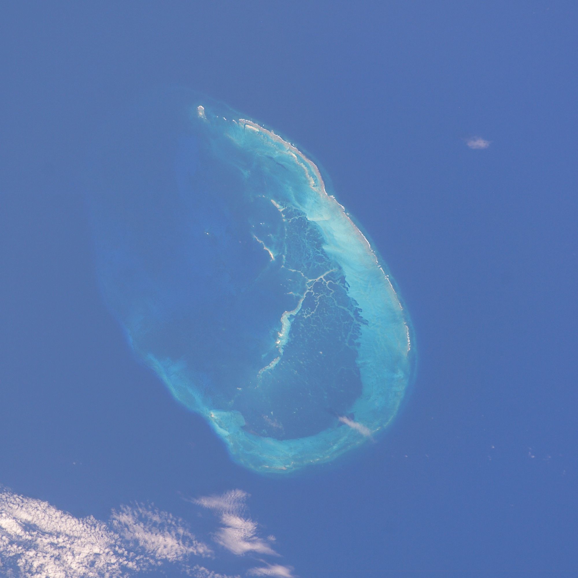
The French Frigate Shoals (Hawaiian: Kānemilohaʻi) is the largest atoll in the Northwestern Hawaiian Islands, located about 487 nautical miles (902 km; 560 mi) northwest of Honolulu. Its name commemorates French explorer Jean-François de Galaup, comte de Lapérouse, who nearly lost two frigates when attempting to navigate the shoals. It consists of a 20-mile-long (32 km) crescent-shaped reef, twelve sandbars, and the 120-foot-high (37 m) La Perouse Pinnacle, the only remnant of its volcanic origins. The total land area of the islets is 61.508 acres (24.891 ha), while the total coral reef area of the shoals is over 232,000 acres (94,000 ha). Tern Island, with an area of 26.014 acres (10.527 ha), has a landing strip and permanent habitations for a small number of people. It is maintained as a field station in the Hawaiian Islands National Wildlife Refuge by the United States Fish and Wildlife Service. East and Trig, the two largest islands after Tern, have mostly washed away. The islands are surrounded by a coral reef, and the islands themselves are noted breeding ground for turtles, seals, and birds. Habitation is difficult with little vegetation and no fresh water. The French Frigate Shoals are also called Lalo as part of the marine nature reserve, and along with other islands are visited periodically for research. The highest point in the shoals is on La Perouse Pinnacle, which is a volcanic rock that rises 122 ft (37 m) above the surrounding lagoon.
In the 20th century, the shoals were used by the Imperial Japanese Navy as part of an operation to attack Hawaii. Afterwards, a small United States Navy base was established there to prevent it from being used again. After the war it was used by the United States Coast Guard for a LORAN radio navigation station. By the 21st century, it was primarily used for oceanographic and biological study as a nature reserve. Studies at the island helped establish the nature of plastic pollution, and in 2020 one island was designated as contaminated by plastic pollution from the ocean. The reefs are noted for having survived many Pacific storms, although these storms have damaged facilities, wildlife, and significantly reduced the area of some islands.
The islands were discovered by the French in the late 18th century and were formally claimed by the United States in 1859 under the Guano Islands Act. The main focus of the USA was to administer the territory as a wildlife refuge, but it became involved in military events during WW2. The shoals were used by Japan as a staging point for their surprise attack on the Hawaiian Islands, but were then occupied by U.S. forces. A few months later, the shoals were again near the front lines in the battle of Midway. After that battle, one island, Tern, was made into an airstrip and base. East Island also had a base. After World War II, the shoals were turned over to Hawaii, and served several purposes. The shoals were used for a LORAN radio location base, and the airstrip was used for fishing. A coast guard base was on the islands until 1979, and then the Fish and Wildlife Service until 2012. One issue was the Pacific storms that affect the islands. In the 21st century, the decayed Tern Island seawall was partially repaired, and in 2018 East Island was nearly washed away. In the 2020s, the shoals are a noted nature reserve, regularly visited for research on marine life, including coral, sharks, fish, seals, sea turtles, and many types of birds. There is also marine archeology conducted on sea wrecks, including a rare whaling vessel wreck.
Although there is no evidence of extensive human activity or presence in the area, the earliest human visitors to the French Frigate Shoals probably came from the main Hawaiian Islands, which were settled by Polynesians between 1100 and 1300 AD.
The Hawaiian island chain lay outside the routes followed by early European explorers, and it was not until Jean-François de Galaup, comte de Lapérouse's near-disastrous discovery that the shoals were known to the outside world. La Pérouse, aboard the frigate Boussole, was sailing westward from Monterey en route to Macau. During the night of 6 November 1786, sailors sighted breakers directly in their path, about a thousand feet ahead. Both the Boussole and her companion vessel, the frigate Astrolabe, were immediately brought about, passing within a few hundred feet of the breakers. At daybreak, the ships returned and mapped the southeastern half of the atoll, as well as finding the rock that would later be named after La Pérouse. La Pérouse named the shoals Basse des Frégates Françaises, the "Shoal of the French Frigates".
The expedition went on to discover the nearby Necker Island. His ships were Astrolabe (under command of Fleuriot de Langle) and the Boussole. La Pérouse was on a mission of exploration from the French Academy of Sciences, and they made many discoveries in across the Pacific. The expedition was lost at sea in 1788 while still on the expedition, but was able to send its logs home.
In 1823, the whaling ship Two Brothers sank near Shark Island. This wreck was discovered in the early 21st century.
Hub AI
French Frigate Shoals AI simulator
(@French Frigate Shoals_simulator)
French Frigate Shoals
23°44′56″N 166°8′46″W / 23.74889°N 166.14611°W
The French Frigate Shoals (Hawaiian: Kānemilohaʻi) is the largest atoll in the Northwestern Hawaiian Islands, located about 487 nautical miles (902 km; 560 mi) northwest of Honolulu. Its name commemorates French explorer Jean-François de Galaup, comte de Lapérouse, who nearly lost two frigates when attempting to navigate the shoals. It consists of a 20-mile-long (32 km) crescent-shaped reef, twelve sandbars, and the 120-foot-high (37 m) La Perouse Pinnacle, the only remnant of its volcanic origins. The total land area of the islets is 61.508 acres (24.891 ha), while the total coral reef area of the shoals is over 232,000 acres (94,000 ha). Tern Island, with an area of 26.014 acres (10.527 ha), has a landing strip and permanent habitations for a small number of people. It is maintained as a field station in the Hawaiian Islands National Wildlife Refuge by the United States Fish and Wildlife Service. East and Trig, the two largest islands after Tern, have mostly washed away. The islands are surrounded by a coral reef, and the islands themselves are noted breeding ground for turtles, seals, and birds. Habitation is difficult with little vegetation and no fresh water. The French Frigate Shoals are also called Lalo as part of the marine nature reserve, and along with other islands are visited periodically for research. The highest point in the shoals is on La Perouse Pinnacle, which is a volcanic rock that rises 122 ft (37 m) above the surrounding lagoon.
In the 20th century, the shoals were used by the Imperial Japanese Navy as part of an operation to attack Hawaii. Afterwards, a small United States Navy base was established there to prevent it from being used again. After the war it was used by the United States Coast Guard for a LORAN radio navigation station. By the 21st century, it was primarily used for oceanographic and biological study as a nature reserve. Studies at the island helped establish the nature of plastic pollution, and in 2020 one island was designated as contaminated by plastic pollution from the ocean. The reefs are noted for having survived many Pacific storms, although these storms have damaged facilities, wildlife, and significantly reduced the area of some islands.
The islands were discovered by the French in the late 18th century and were formally claimed by the United States in 1859 under the Guano Islands Act. The main focus of the USA was to administer the territory as a wildlife refuge, but it became involved in military events during WW2. The shoals were used by Japan as a staging point for their surprise attack on the Hawaiian Islands, but were then occupied by U.S. forces. A few months later, the shoals were again near the front lines in the battle of Midway. After that battle, one island, Tern, was made into an airstrip and base. East Island also had a base. After World War II, the shoals were turned over to Hawaii, and served several purposes. The shoals were used for a LORAN radio location base, and the airstrip was used for fishing. A coast guard base was on the islands until 1979, and then the Fish and Wildlife Service until 2012. One issue was the Pacific storms that affect the islands. In the 21st century, the decayed Tern Island seawall was partially repaired, and in 2018 East Island was nearly washed away. In the 2020s, the shoals are a noted nature reserve, regularly visited for research on marine life, including coral, sharks, fish, seals, sea turtles, and many types of birds. There is also marine archeology conducted on sea wrecks, including a rare whaling vessel wreck.
Although there is no evidence of extensive human activity or presence in the area, the earliest human visitors to the French Frigate Shoals probably came from the main Hawaiian Islands, which were settled by Polynesians between 1100 and 1300 AD.
The Hawaiian island chain lay outside the routes followed by early European explorers, and it was not until Jean-François de Galaup, comte de Lapérouse's near-disastrous discovery that the shoals were known to the outside world. La Pérouse, aboard the frigate Boussole, was sailing westward from Monterey en route to Macau. During the night of 6 November 1786, sailors sighted breakers directly in their path, about a thousand feet ahead. Both the Boussole and her companion vessel, the frigate Astrolabe, were immediately brought about, passing within a few hundred feet of the breakers. At daybreak, the ships returned and mapped the southeastern half of the atoll, as well as finding the rock that would later be named after La Pérouse. La Pérouse named the shoals Basse des Frégates Françaises, the "Shoal of the French Frigates".
The expedition went on to discover the nearby Necker Island. His ships were Astrolabe (under command of Fleuriot de Langle) and the Boussole. La Pérouse was on a mission of exploration from the French Academy of Sciences, and they made many discoveries in across the Pacific. The expedition was lost at sea in 1788 while still on the expedition, but was able to send its logs home.
In 1823, the whaling ship Two Brothers sank near Shark Island. This wreck was discovered in the early 21st century.