Recent from talks
Gandhinagar
Knowledge base stats:
Talk channels stats:
Members stats:
Gandhinagar
Gandhinagar (Gujarati: gāndhīnagara, pronounced ['ɡaːnd̪ʱinəɡəɾᵊ] ⓘ) is the capital of the state of Gujarat in India. Gandhinagar is located approximately 23 kilometres (14 mi) north of Ahmedabad, on the west central point of the industrial corridor between the megacities of Delhi and Mumbai.
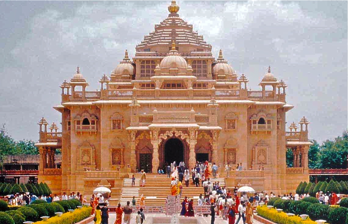
Gandhinagar lies on the west bank of the Sabarmati River, about 545 kilometres (339 mi) north of Mumbai and 901 kilometres (560 mi) southwest of Delhi. The Akshardham temple is located in Gandhinagar. There was a determination to make Gandhinagar a purely Indian enterprise, partly because the state of Gujarat was the birthplace of Mahatma Gandhi. For this reason, the planning was done by two Indian town planners: Prakash M Apte and H. K. Mewada, who had apprenticed with Le Corbusier in Chandigarh.
The name of the city means "Gandhi's city" and it is named after Mahatma Gandhi.
The city was planned by Chief Architect H.K. Mewada, a Cornell University graduate, and his assistant Prakash M Apte.[when?] It was developed in the 1960s.
According to the 2011[update] census of India, Gandhinagar had a population of 208,299. Males constitute 53% of the population and females 47%. Gandhinagar has an average literacy rate of 90%. Male literacy is 91%, and female literacy is 89%. In Gandhinagar, 11% of the population is under 6 years of age. Over 95% of the population of Gandhinagar are Hindus.
Gandhinagar has an average elevation of 81 metres (266 feet). The city sits on the banks of the Sabarmati River, in north-central-east Gujarat. The 20,543 km2 area around Gandhinagar is defined by Gujarat capital territory. Gandhinagar spans an area of 326 km2 (126 sq mi). The river frequently dries up in the summer, leaving only a small stream of water. Gandhinagar is India's tree capital with 54% green cover on its land area.
Gandhinagar has a hot semi-arid climate (Köppen BSh) with three main seasons: summer, monsoon and winter. The climate is generally dry and hot outside of the monsoon season. The weather is hot to severely hot from March to May when the maximum temperature stays in the range of 36 to 42 °C (97 to 108 °F), and the minimum in the range of 19 to 27 °C (66 to 81 °F). It is pleasant in the winter days and quite chilling in the night during December to February. The average maximum temperature is around 29 °C (84 °F), the average minimum is 13 °C (55 °F), and the climate is extremely dry. The southwest monsoon brings a humid climate from mid-June to mid-September. The average annual rainfall is around 773.6 mm (30.46 in).
On 1 May 1960, Gujarat was created out of the 17 northern districts of the former State of Bombay. These districts were further subdivided later on. There are 33 administrative districts in the state. Gandhinagar is a political hub for the state of Gujarat.
Hub AI
Gandhinagar AI simulator
(@Gandhinagar_simulator)
Gandhinagar
Gandhinagar (Gujarati: gāndhīnagara, pronounced ['ɡaːnd̪ʱinəɡəɾᵊ] ⓘ) is the capital of the state of Gujarat in India. Gandhinagar is located approximately 23 kilometres (14 mi) north of Ahmedabad, on the west central point of the industrial corridor between the megacities of Delhi and Mumbai.
Gandhinagar lies on the west bank of the Sabarmati River, about 545 kilometres (339 mi) north of Mumbai and 901 kilometres (560 mi) southwest of Delhi. The Akshardham temple is located in Gandhinagar. There was a determination to make Gandhinagar a purely Indian enterprise, partly because the state of Gujarat was the birthplace of Mahatma Gandhi. For this reason, the planning was done by two Indian town planners: Prakash M Apte and H. K. Mewada, who had apprenticed with Le Corbusier in Chandigarh.
The name of the city means "Gandhi's city" and it is named after Mahatma Gandhi.
The city was planned by Chief Architect H.K. Mewada, a Cornell University graduate, and his assistant Prakash M Apte.[when?] It was developed in the 1960s.
According to the 2011[update] census of India, Gandhinagar had a population of 208,299. Males constitute 53% of the population and females 47%. Gandhinagar has an average literacy rate of 90%. Male literacy is 91%, and female literacy is 89%. In Gandhinagar, 11% of the population is under 6 years of age. Over 95% of the population of Gandhinagar are Hindus.
Gandhinagar has an average elevation of 81 metres (266 feet). The city sits on the banks of the Sabarmati River, in north-central-east Gujarat. The 20,543 km2 area around Gandhinagar is defined by Gujarat capital territory. Gandhinagar spans an area of 326 km2 (126 sq mi). The river frequently dries up in the summer, leaving only a small stream of water. Gandhinagar is India's tree capital with 54% green cover on its land area.
Gandhinagar has a hot semi-arid climate (Köppen BSh) with three main seasons: summer, monsoon and winter. The climate is generally dry and hot outside of the monsoon season. The weather is hot to severely hot from March to May when the maximum temperature stays in the range of 36 to 42 °C (97 to 108 °F), and the minimum in the range of 19 to 27 °C (66 to 81 °F). It is pleasant in the winter days and quite chilling in the night during December to February. The average maximum temperature is around 29 °C (84 °F), the average minimum is 13 °C (55 °F), and the climate is extremely dry. The southwest monsoon brings a humid climate from mid-June to mid-September. The average annual rainfall is around 773.6 mm (30.46 in).
On 1 May 1960, Gujarat was created out of the 17 northern districts of the former State of Bombay. These districts were further subdivided later on. There are 33 administrative districts in the state. Gandhinagar is a political hub for the state of Gujarat.
Recent media