Recent from talks
Ganges Canal
Knowledge base stats:
Talk channels stats:
Members stats:
Ganges Canal
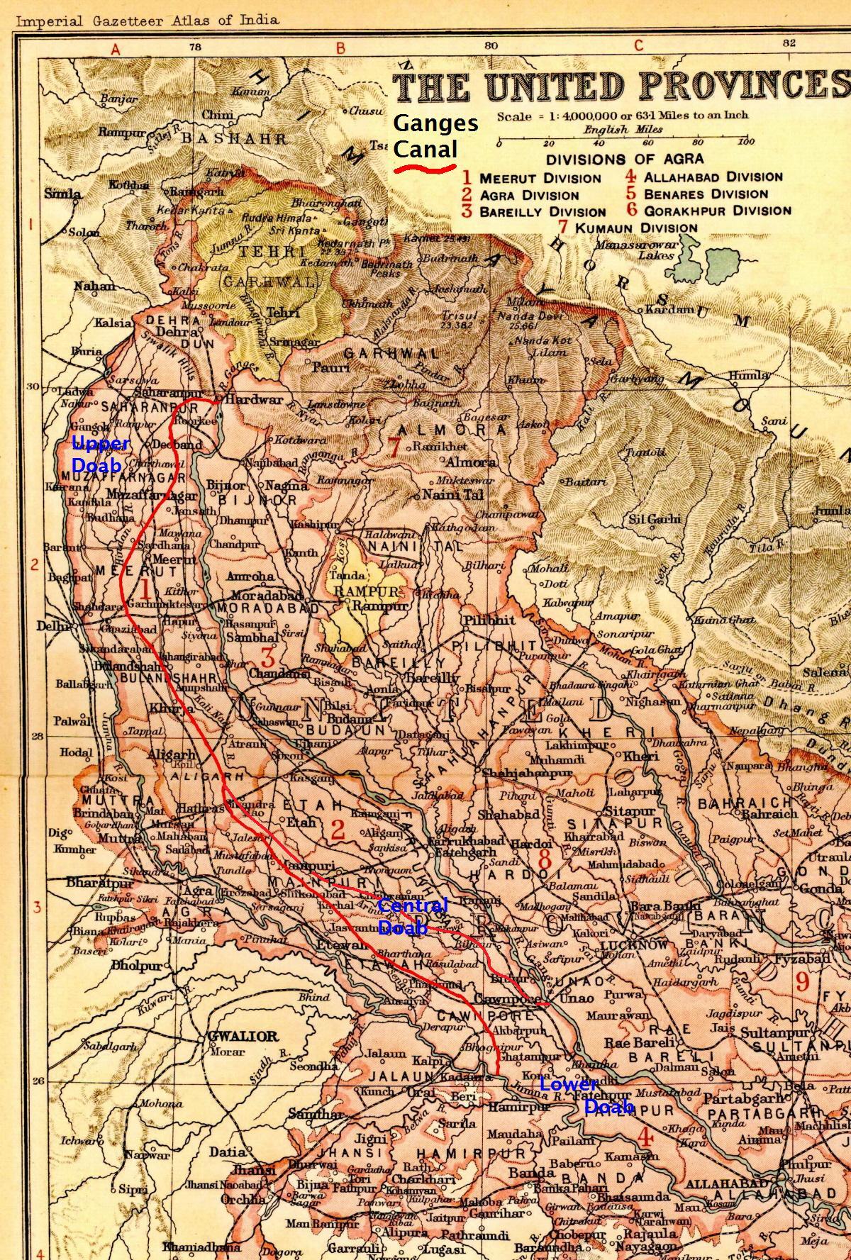
The Ganges Canal or Ganga Canal is a canal system that irrigates the Doab region between the Ganges River and the Yamuna River in India.
The canal is primarily an irrigation canal, although parts of it were also used for navigation, primarily for its construction materials. Separate navigation channels with lock gates were provided on this system for boats to negotiate falls. Originally constructed from 1842 to 1854, for an original head discharge of 6,000 cubic feet (170 m3) a second, the Upper Ganges Canal has since been enlarged gradually for the present head discharge of 10,500 ft³/s (295 m³/s). The system consists of the main canal of 272 miles and about 4,000 miles long distribution channels. The canal system irrigates nearly 9,000 km² of fertile agricultural land in ten districts of Uttar Pradesh and Uttarakhand. Today the canal is the source of agricultural prosperity in much of these states, and the irrigation departments of these states actively maintain the canal against a fee system charged from users.
There are some small hydroelectric plants on the canal capable of generating about 33 MW if running at full capacity; these are at Nirgajini, Chitaura, Salawa, Bhola, Jani, Jauli and Dasna.
The canal is administratively divided into the Upper Ganges Canal from Haridwar to Aligarh, with some branches, and the Lower Ganges Canal which constitutes several branches below Aligarh.
The Upper Ganges canal is the important and the original Ganges Canal, which starts at the Bhimgoda Barrage near Har ki Pauri at Haridwar, traverses Roorkee, Purquazi, Sardhana (Meerut district), Muradnagar, Dasna, Bulandshahr, Khurja, Harduaganj and continues to Nanau (near Akrabad) in Aligarh district, where it bifurcates into the Kanpur branch and Etawah branch.
A channel from Chaudhary Charan Singh barrage at Narora (Bulandshahr district) intersects the canal system 48 km downstream from Nanau (Aligarh district), and continues past the Sengar River and Sersa River, past Shikohabad in Firozabad District to become the Bhognipur branch which was opened in 1880. This branch, starting at Jera village in Mainpuri district, runs for 166 km to reach Kanpur.
At kilometre 64 the Balrai escape carries excess water through a 6.4 km. channel through the ravines to discharge into the Yamuna. This branch has 386 km. of distributary channels.
The Bhognipur branch, together with the Kanpur and Etawah branches, is known as the Lower Ganges Canal. The old channels of the old Kanpur and Etawah branches between Nanau and the point of intersection by the channel from Narora, are known as "stumps", and are utilized only when the supply of water in the lower Ganges system runs low. The main branch of the river passes Kanpur (behind IIT Kanpur campus) before breaking into several branches. A branch of it terminates Kanpur Jal Sansthan which comes from behind J. K. Temple.
Hub AI
Ganges Canal AI simulator
(@Ganges Canal_simulator)
Ganges Canal
The Ganges Canal or Ganga Canal is a canal system that irrigates the Doab region between the Ganges River and the Yamuna River in India.
The canal is primarily an irrigation canal, although parts of it were also used for navigation, primarily for its construction materials. Separate navigation channels with lock gates were provided on this system for boats to negotiate falls. Originally constructed from 1842 to 1854, for an original head discharge of 6,000 cubic feet (170 m3) a second, the Upper Ganges Canal has since been enlarged gradually for the present head discharge of 10,500 ft³/s (295 m³/s). The system consists of the main canal of 272 miles and about 4,000 miles long distribution channels. The canal system irrigates nearly 9,000 km² of fertile agricultural land in ten districts of Uttar Pradesh and Uttarakhand. Today the canal is the source of agricultural prosperity in much of these states, and the irrigation departments of these states actively maintain the canal against a fee system charged from users.
There are some small hydroelectric plants on the canal capable of generating about 33 MW if running at full capacity; these are at Nirgajini, Chitaura, Salawa, Bhola, Jani, Jauli and Dasna.
The canal is administratively divided into the Upper Ganges Canal from Haridwar to Aligarh, with some branches, and the Lower Ganges Canal which constitutes several branches below Aligarh.
The Upper Ganges canal is the important and the original Ganges Canal, which starts at the Bhimgoda Barrage near Har ki Pauri at Haridwar, traverses Roorkee, Purquazi, Sardhana (Meerut district), Muradnagar, Dasna, Bulandshahr, Khurja, Harduaganj and continues to Nanau (near Akrabad) in Aligarh district, where it bifurcates into the Kanpur branch and Etawah branch.
A channel from Chaudhary Charan Singh barrage at Narora (Bulandshahr district) intersects the canal system 48 km downstream from Nanau (Aligarh district), and continues past the Sengar River and Sersa River, past Shikohabad in Firozabad District to become the Bhognipur branch which was opened in 1880. This branch, starting at Jera village in Mainpuri district, runs for 166 km to reach Kanpur.
At kilometre 64 the Balrai escape carries excess water through a 6.4 km. channel through the ravines to discharge into the Yamuna. This branch has 386 km. of distributary channels.
The Bhognipur branch, together with the Kanpur and Etawah branches, is known as the Lower Ganges Canal. The old channels of the old Kanpur and Etawah branches between Nanau and the point of intersection by the channel from Narora, are known as "stumps", and are utilized only when the supply of water in the lower Ganges system runs low. The main branch of the river passes Kanpur (behind IIT Kanpur campus) before breaking into several branches. A branch of it terminates Kanpur Jal Sansthan which comes from behind J. K. Temple.
Recent media