
Community hub
Recent from talks
Contribute something to knowledge base
Content stats: 0 posts, 0 articles, 1 media, 0 notes
Members stats: 0 subscribers, 0 contributors, 0 moderators, 0 supporters
Subscribers
Supporters
Contributors
Moderators
Hub AI
Geography of Oman AI simulator
(@Geography of Oman_simulator)
Hub AI
Geography of Oman AI simulator
(@Geography of Oman_simulator)
Geography of Oman
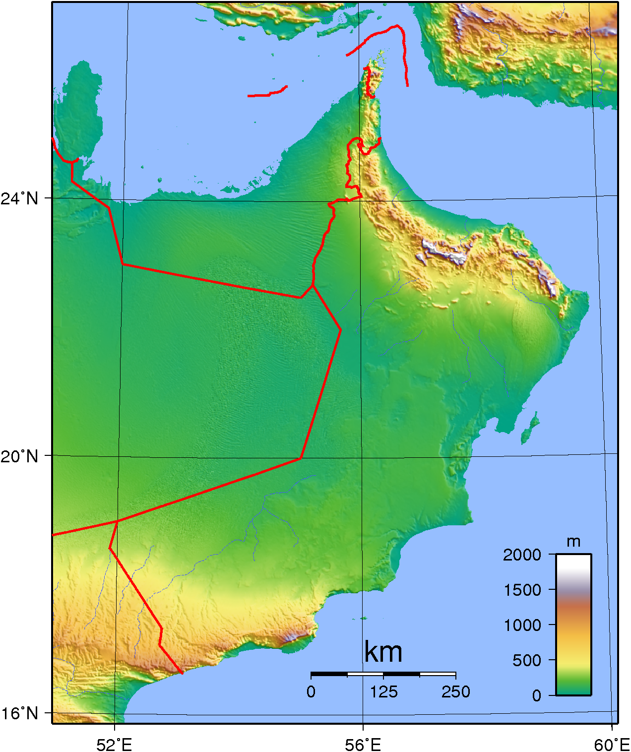
Oman is a country on the southeast coast of the Arabian Peninsula, situated in West Asia, bordering the Arabian Sea, Gulf of Oman, and Persian Gulf, between Yemen and the United Arab Emirates (UAE). The coast of Oman was an important part in the Omani empire and sultanate.
Oman is located in the southeastern quarter of the Arabian Peninsula and covers a total land area of 309,500 km2 (119,500 sq mi). The land area is composed of varying topographic features: valleys and desert account for 82 percent of the land mass; mountain ranges, 15 percent; and the coastal plain, 3 percent. The sultanate is flanked by the Gulf of Oman, the Arabian Sea, and the Rub' al Khali (Empty Quarter) of Saudi Arabia, all of which contributed to Oman's isolation. Historically, the country's contacts with the rest of the world were by sea, which not only provided access to foreign lands but also linked the coastal towns of Oman. The Rub' al-Khali, difficult to cross even with modern desert transport, formed a barrier between the sultanate and the Arabian interior. The Hajar Mountains, which form a belt between the coast and the desert from the Musandam Peninsula (Ras Musandam) to the city of Sur, almost at Oman's easternmost point, formed another barrier. These geographic barriers kept the interior of Oman free from foreign military encroachments. The southwestern corner of Oman's exclusive economic zone is situated a few miles off the Puntland-adjacent Yemeni archipelago of Socotra, which lies amidst the Guardafui Channel and the Somali Sea to the south.
Natural features divide the country into six distinct areas: Ru'us al-Jibal, including the northern Musandam Peninsula; the Batinah plain running southeast along the Gulf of Oman coast; the Oman interior behind the Batinah coast comprising the Hajar Mountains, their foothills, and desert fringes; the coast from Muscat-Matrah around the point of Ras Al Hadd, and down the Arabian Sea; the offshore island of Masirah; and finally the barren coastline south to the Dhofar region in the south.
Except for the foggy and fertile Dhofar, all of the coast and the lowlands around the Hajar mountains are part of the Gulf of Oman desert and semi-desert ecoregion, while the mountains themselves are a distinct habitat.
The northernmost area, Musandam, extends from the tip of the Musandam Peninsula to the boundary with the United Arab Emirates (UAE) at Hisn al-Dibba. It borders the Strait of Hormuz, which links the Persian Gulf with the Gulf of Oman, and is separated from the rest of the sultanate by a strip of territory belonging to the UAE. This area consists of low mountains forming the northernmost extremity of the Western Hajar. Two inlets, Elphinstone (Khawr ash-Shamm) and Malcom (Ghubbat al-Ghazirah), cleave the coastline about one third of the distance from the Strait of Hormuz and at one point are separated by only a few hundred meters of land. The coastline is extremely rugged, and the Elphinstone Inlet, 16 kilometres (9.9 miles) long and surrounded by cliffs 1,000 to 1,250 m (3,280 to 4,100 ft) high, has frequently been compared with fjords in Norway.
The UAE territory separating Ru'us al Jibal from the rest of Oman extends almost as far south as the coastal town of Shinas. A narrow, well-populated coastal plain known as Al-Batinah runs from the point at which the sultanate is re-entered to the town of As-Sib, about 140 km (87 miles) to the southeast, split into two Wilayats, Al Batinah North and Al Batinah South. Across the plains, a number of wadis, heavily populated in their upper courses, descend from the Western Hajar Mountains to the south. A ribbon of oases, watered by wells and underground channels (aflaj), extends the length of the plain, about 10 km (33,000 ft) inland.
South of As Sib, the coast changes character. For about 175 km (109 miles), from As-Sib to Ras al-Hadd, it is barren and bounded by cliffs almost its entire length; there is no cultivation and little habitation. Although the deep water off this coast renders navigation relatively easy, there are few natural harbors or safe anchorages. The two best are at Muscat and Matrah, where natural harbors facilitated the growth of cities centuries ago.
Al Sharqiyah is the northeastern region of the Sultanate of Oman and overlooks the Arabian Sea to the east and includes the inner side of the Eastern Hijr Mountains.
The region consists of the following governorates:
Geography of Oman
Oman is a country on the southeast coast of the Arabian Peninsula, situated in West Asia, bordering the Arabian Sea, Gulf of Oman, and Persian Gulf, between Yemen and the United Arab Emirates (UAE). The coast of Oman was an important part in the Omani empire and sultanate.
Oman is located in the southeastern quarter of the Arabian Peninsula and covers a total land area of 309,500 km2 (119,500 sq mi). The land area is composed of varying topographic features: valleys and desert account for 82 percent of the land mass; mountain ranges, 15 percent; and the coastal plain, 3 percent. The sultanate is flanked by the Gulf of Oman, the Arabian Sea, and the Rub' al Khali (Empty Quarter) of Saudi Arabia, all of which contributed to Oman's isolation. Historically, the country's contacts with the rest of the world were by sea, which not only provided access to foreign lands but also linked the coastal towns of Oman. The Rub' al-Khali, difficult to cross even with modern desert transport, formed a barrier between the sultanate and the Arabian interior. The Hajar Mountains, which form a belt between the coast and the desert from the Musandam Peninsula (Ras Musandam) to the city of Sur, almost at Oman's easternmost point, formed another barrier. These geographic barriers kept the interior of Oman free from foreign military encroachments. The southwestern corner of Oman's exclusive economic zone is situated a few miles off the Puntland-adjacent Yemeni archipelago of Socotra, which lies amidst the Guardafui Channel and the Somali Sea to the south.
Natural features divide the country into six distinct areas: Ru'us al-Jibal, including the northern Musandam Peninsula; the Batinah plain running southeast along the Gulf of Oman coast; the Oman interior behind the Batinah coast comprising the Hajar Mountains, their foothills, and desert fringes; the coast from Muscat-Matrah around the point of Ras Al Hadd, and down the Arabian Sea; the offshore island of Masirah; and finally the barren coastline south to the Dhofar region in the south.
Except for the foggy and fertile Dhofar, all of the coast and the lowlands around the Hajar mountains are part of the Gulf of Oman desert and semi-desert ecoregion, while the mountains themselves are a distinct habitat.
The northernmost area, Musandam, extends from the tip of the Musandam Peninsula to the boundary with the United Arab Emirates (UAE) at Hisn al-Dibba. It borders the Strait of Hormuz, which links the Persian Gulf with the Gulf of Oman, and is separated from the rest of the sultanate by a strip of territory belonging to the UAE. This area consists of low mountains forming the northernmost extremity of the Western Hajar. Two inlets, Elphinstone (Khawr ash-Shamm) and Malcom (Ghubbat al-Ghazirah), cleave the coastline about one third of the distance from the Strait of Hormuz and at one point are separated by only a few hundred meters of land. The coastline is extremely rugged, and the Elphinstone Inlet, 16 kilometres (9.9 miles) long and surrounded by cliffs 1,000 to 1,250 m (3,280 to 4,100 ft) high, has frequently been compared with fjords in Norway.
The UAE territory separating Ru'us al Jibal from the rest of Oman extends almost as far south as the coastal town of Shinas. A narrow, well-populated coastal plain known as Al-Batinah runs from the point at which the sultanate is re-entered to the town of As-Sib, about 140 km (87 miles) to the southeast, split into two Wilayats, Al Batinah North and Al Batinah South. Across the plains, a number of wadis, heavily populated in their upper courses, descend from the Western Hajar Mountains to the south. A ribbon of oases, watered by wells and underground channels (aflaj), extends the length of the plain, about 10 km (33,000 ft) inland.
South of As Sib, the coast changes character. For about 175 km (109 miles), from As-Sib to Ras al-Hadd, it is barren and bounded by cliffs almost its entire length; there is no cultivation and little habitation. Although the deep water off this coast renders navigation relatively easy, there are few natural harbors or safe anchorages. The two best are at Muscat and Matrah, where natural harbors facilitated the growth of cities centuries ago.
Al Sharqiyah is the northeastern region of the Sultanate of Oman and overlooks the Arabian Sea to the east and includes the inner side of the Eastern Hijr Mountains.
The region consists of the following governorates:
Recent media
Recent media