
Community hub
Recent from talks
Contribute something to knowledge base
Content stats: 0 posts, 0 articles, 1 media, 0 notes
Members stats: 0 subscribers, 0 contributors, 0 moderators, 0 supporters
Subscribers
Supporters
Contributors
Moderators
Hub AI
Geography of Vermont AI simulator
(@Geography of Vermont_simulator)
Hub AI
Geography of Vermont AI simulator
(@Geography of Vermont_simulator)
Geography of Vermont
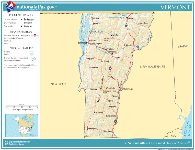
The U.S. state of Vermont is located in the New England region of the northeastern United States and comprises 9,614 square miles (24,900 km2), making it the 45th-largest state. Land comprises 9,250 square miles (24,000 km2) and water comprises 365 square miles (950 km2), making it the 43rd-largest in land area and the 47th in water area. In total area, it is larger than El Salvador and smaller than Haiti. It is the only landlocked state in New England, and it is the easternmost and the smallest in area of all landlocked states.
Vermont's overall geography can be best characterized as extremely rugged and densely forested, with outposts of civilization centered around rivers and the (relatively) flat and arable Champlain Valley in the northwest, and ultimately divided by the Green Mountains, which contribute to a rural and very much Appalachian landscape. The average elevation of Vermont is 1000 feet above sea level, and the highest elevation is the summit of Mount Mansfield at 4,395 feet above sea level.
The Green Mountains in Vermont form a north–south spine running most of the length of the state, slightly west of its center. In the southwest portion of the state are located the Taconic Mountains. In the northwest, near Lake Champlain, is the fertile Champlain Valley. In the south of the valley is Lake Bomoseen. Many towns and villages in Vermont are separated by (comparatively) lower hills and mountains, connected by rural highways and high passes referred to variously as notches, gaps or gulfs. The endless rugged terrain contributes heavily to Vermont's rural character and acts as a natural barrier to large scale population growth. Indeed, 66% of all mileage of road in Vermont is "paved" with dirt or gravel, and annually results in springtime's mud season, where runoff snowmelt causes dirt backroads to become nearly impassable to motor vehicles, often to the amusement of locals.
Vermont's extremely rugged terrain is the almost certain explanation for why the state has remained so sparsely populated; After Maine, Vermont has the lowest population density of any state east of the Mississippi River. Burlington, at only ~45,000 people is the largest city, and is situated in the (relatively) flat and populated Champlain Valley.
Lake Champlain, the sixth-largest body of fresh water in the United States, separates Vermont from New York in the northwest portion of the state. From north to south, Vermont is 159 miles (256 km) long. Its greatest width, from east to west, is 89 miles (143 km) at the Canada–U.S. border; the narrowest width is 37 miles (60 km) near the Massachusetts border. The width averages 60.5 miles (97.4 km). The state's geographic center is approximately three miles (5 km) east of Roxbury, in Washington County. There are fifteen U.S. federal border crossings between Vermont and Canada.
Several mountains have timberlines with delicate year-round alpine ecosystems, including Mount Mansfield, the highest mountain in the state; Killington Peak, the second-highest; Camel's Hump, the state's third-highest; and Mount Abraham, the fifth-highest peak. Areas in Vermont administered by the National Park Service include the Marsh-Billings-Rockefeller National Historical Park (in Woodstock) and the Appalachian National Scenic Trail.
On July 20, 1764, King George III signed an Order in Council establishing, among other things, two boundaries of the Province of New York which have been inherited by Vermont. The eastern border was set at the mean low water mark of the west bank of the Connecticut River, meaning most of the water in the river is in New Hampshire. 41% of Vermont's land area is part of the Connecticut River's watershed.
George set the northern boundary with the Province of Quebec at the 45th parallel north, from the Connecticut River to the St. Lawrence River. The Collins–Valentine line was surveyed along this parallel from 1771 to 1773. It was later discovered to deviate northward from the intended location by over a thousand feet in places. The 1842 Webster–Ashburton Treaty affirmed the legal boundary is where the Collins–Valentine markers are, not the exact 45th parallel, leaving Vermont with a small amount of additional territory.
Geography of Vermont
The U.S. state of Vermont is located in the New England region of the northeastern United States and comprises 9,614 square miles (24,900 km2), making it the 45th-largest state. Land comprises 9,250 square miles (24,000 km2) and water comprises 365 square miles (950 km2), making it the 43rd-largest in land area and the 47th in water area. In total area, it is larger than El Salvador and smaller than Haiti. It is the only landlocked state in New England, and it is the easternmost and the smallest in area of all landlocked states.
Vermont's overall geography can be best characterized as extremely rugged and densely forested, with outposts of civilization centered around rivers and the (relatively) flat and arable Champlain Valley in the northwest, and ultimately divided by the Green Mountains, which contribute to a rural and very much Appalachian landscape. The average elevation of Vermont is 1000 feet above sea level, and the highest elevation is the summit of Mount Mansfield at 4,395 feet above sea level.
The Green Mountains in Vermont form a north–south spine running most of the length of the state, slightly west of its center. In the southwest portion of the state are located the Taconic Mountains. In the northwest, near Lake Champlain, is the fertile Champlain Valley. In the south of the valley is Lake Bomoseen. Many towns and villages in Vermont are separated by (comparatively) lower hills and mountains, connected by rural highways and high passes referred to variously as notches, gaps or gulfs. The endless rugged terrain contributes heavily to Vermont's rural character and acts as a natural barrier to large scale population growth. Indeed, 66% of all mileage of road in Vermont is "paved" with dirt or gravel, and annually results in springtime's mud season, where runoff snowmelt causes dirt backroads to become nearly impassable to motor vehicles, often to the amusement of locals.
Vermont's extremely rugged terrain is the almost certain explanation for why the state has remained so sparsely populated; After Maine, Vermont has the lowest population density of any state east of the Mississippi River. Burlington, at only ~45,000 people is the largest city, and is situated in the (relatively) flat and populated Champlain Valley.
Lake Champlain, the sixth-largest body of fresh water in the United States, separates Vermont from New York in the northwest portion of the state. From north to south, Vermont is 159 miles (256 km) long. Its greatest width, from east to west, is 89 miles (143 km) at the Canada–U.S. border; the narrowest width is 37 miles (60 km) near the Massachusetts border. The width averages 60.5 miles (97.4 km). The state's geographic center is approximately three miles (5 km) east of Roxbury, in Washington County. There are fifteen U.S. federal border crossings between Vermont and Canada.
Several mountains have timberlines with delicate year-round alpine ecosystems, including Mount Mansfield, the highest mountain in the state; Killington Peak, the second-highest; Camel's Hump, the state's third-highest; and Mount Abraham, the fifth-highest peak. Areas in Vermont administered by the National Park Service include the Marsh-Billings-Rockefeller National Historical Park (in Woodstock) and the Appalachian National Scenic Trail.
On July 20, 1764, King George III signed an Order in Council establishing, among other things, two boundaries of the Province of New York which have been inherited by Vermont. The eastern border was set at the mean low water mark of the west bank of the Connecticut River, meaning most of the water in the river is in New Hampshire. 41% of Vermont's land area is part of the Connecticut River's watershed.
George set the northern boundary with the Province of Quebec at the 45th parallel north, from the Connecticut River to the St. Lawrence River. The Collins–Valentine line was surveyed along this parallel from 1771 to 1773. It was later discovered to deviate northward from the intended location by over a thousand feet in places. The 1842 Webster–Ashburton Treaty affirmed the legal boundary is where the Collins–Valentine markers are, not the exact 45th parallel, leaving Vermont with a small amount of additional territory.
Recent media
Recent media