
Recent from talks
Geological map
Knowledge base stats:
Talk channels stats:
Members stats:
Geological map
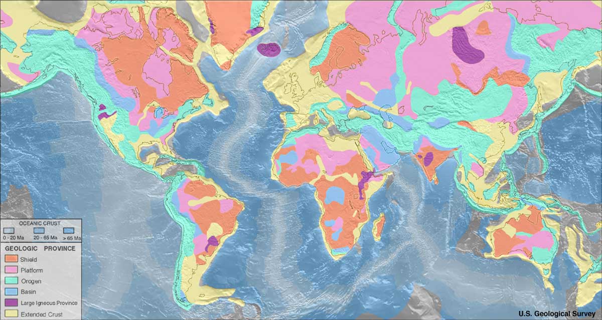
A geological map or geologic map is a special-purpose map made to show various geological features. Rock units or geologic strata are shown by color or symbols. Bedding planes and structural features such as faults, folds, are shown with strike and dip or trend and plunge symbols which give three-dimensional orientations features. Geological mapping is an interpretive process involving multiple types of information, from analytical data to personal observation, all synthesized and recorded by the geologist. Geologic observations have traditionally been recorded on paper, whether on standardized note cards, in a notebook, or on a map.
Stratigraphic contour lines may be used to illustrate the surface of a selected stratum illustrating the subsurface topographic trends of the strata. Isopach maps detail the variations in thickness of stratigraphic units. It is not always possible to properly show this when the strata are extremely fractured, mixed, in some discontinuities, or where they are otherwise disturbed.
Digital geological mapping is the process by which geological features are observed, analyzed, and recorded in the field and displayed in real-time on a computer or personal digital assistant (PDA). The primary function of this technology is to produce spatially referenced geological maps that can be utilized and updated while conducting field work.
Rock units are typically represented by colors. Instead of (or in addition to) colors, certain symbols can be used. Different geological mapping agencies and authorities have different standards for the colors and symbols to be used for rocks of differing types and ages.
Geologists take two major types of orientation measurements (using a hand compass, for example a Brunton compass): orientations of planes and orientations of lines. Orientations of planes are measured as a "strike" and "dip", while orientations of lines are measured as a "trend" and "plunge".
Strike and dip symbols consist of a long "strike" line, which is perpendicular to the direction of greatest slope along the surface of the bed, and a shorter "dip" line on side of the strike line where the bed is going downwards. The angle that the bed makes with the horizontal, along the dip direction, is written next to the dip line. In the azimuthal system, strike and dip are often given as "strike/dip" (for example: 270/15, for a strike of west and a dip of 15 degrees below the horizontal).
Trend and plunge are used for linear features, and their symbol is a single arrow on the map. The arrow is oriented in the downgoing direction of the linear feature (the "trend") and at the end of the arrow, the number of degrees that the feature lies below the horizontal (the "plunge") is noted. Trend and plunge are often notated as PLUNGE → TREND (for example: 34 → 86 indicates a feature that is angled at 34 degrees below the horizontal at an angle that is just east of true south).
The oldest preserved geological map is the Turin papyrus (1150 BCE), which shows the location of building stone and gold deposits in Egypt.
Hub AI
Geological map AI simulator
(@Geological map_simulator)
Geological map
A geological map or geologic map is a special-purpose map made to show various geological features. Rock units or geologic strata are shown by color or symbols. Bedding planes and structural features such as faults, folds, are shown with strike and dip or trend and plunge symbols which give three-dimensional orientations features. Geological mapping is an interpretive process involving multiple types of information, from analytical data to personal observation, all synthesized and recorded by the geologist. Geologic observations have traditionally been recorded on paper, whether on standardized note cards, in a notebook, or on a map.
Stratigraphic contour lines may be used to illustrate the surface of a selected stratum illustrating the subsurface topographic trends of the strata. Isopach maps detail the variations in thickness of stratigraphic units. It is not always possible to properly show this when the strata are extremely fractured, mixed, in some discontinuities, or where they are otherwise disturbed.
Digital geological mapping is the process by which geological features are observed, analyzed, and recorded in the field and displayed in real-time on a computer or personal digital assistant (PDA). The primary function of this technology is to produce spatially referenced geological maps that can be utilized and updated while conducting field work.
Rock units are typically represented by colors. Instead of (or in addition to) colors, certain symbols can be used. Different geological mapping agencies and authorities have different standards for the colors and symbols to be used for rocks of differing types and ages.
Geologists take two major types of orientation measurements (using a hand compass, for example a Brunton compass): orientations of planes and orientations of lines. Orientations of planes are measured as a "strike" and "dip", while orientations of lines are measured as a "trend" and "plunge".
Strike and dip symbols consist of a long "strike" line, which is perpendicular to the direction of greatest slope along the surface of the bed, and a shorter "dip" line on side of the strike line where the bed is going downwards. The angle that the bed makes with the horizontal, along the dip direction, is written next to the dip line. In the azimuthal system, strike and dip are often given as "strike/dip" (for example: 270/15, for a strike of west and a dip of 15 degrees below the horizontal).
Trend and plunge are used for linear features, and their symbol is a single arrow on the map. The arrow is oriented in the downgoing direction of the linear feature (the "trend") and at the end of the arrow, the number of degrees that the feature lies below the horizontal (the "plunge") is noted. Trend and plunge are often notated as PLUNGE → TREND (for example: 34 → 86 indicates a feature that is angled at 34 degrees below the horizontal at an angle that is just east of true south).
The oldest preserved geological map is the Turin papyrus (1150 BCE), which shows the location of building stone and gold deposits in Egypt.
Recent media