Community hub
Recent from talks
Knowledge base stats:
Talk channels stats:
Members stats:
Geography of Qatar
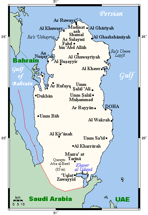
Qatar is a peninsula in the east of Arabia, bordering the Persian Gulf and Saudi Arabia in a strategic location near major petroleum and natural gas deposits. The State of Qatar occupies 11,571 km2 (4,468 sq mi) on a peninsula that extends about 160 km (99 mi) north into the Persian Gulf from the Arabian Peninsula.
Varying in width between 55 and 90 km (34 and 56 mi), the land is mainly flat (the highest point is 103 m (338 ft)) and rocky. Notable features include coastal salt pans, elevated limestone formations (the Dukhan anticline) along the west coast under which lies the Dukhan oil field, and massive sand dunes surrounding Khor Al Adaid, an inlet of the Persian Gulf in the southeast known to local English speakers as the Inland Sea.
Qatar has one land border. The country borders Saudi Arabia to the south. The boundary with Saudi Arabia was settled in 1965 but never demarcated. This terrestrial sector extends from the head of the Gulf of Salwah at Abu Samra to Khor Al Adaid, spanning a linear distance of approximately 87 kilometres (54 mi).
Qatar presents as a peninsula encompassed by the tepid waters of the Persian Gulf on its eastern and northern flanks. The western margin is delineated by the Gulf of Salwah, a concave formation which effectively severs Qatar's terrestrial connection with the Al-Ahsa coast and Bahrain.
Qatar's northwest coast is fewer than 30 km (19 mi) from the main islands of Bahrain, while the small Hawar Islands of Bahrain are only 1.9 kilometres (1.2 mi) off the coast. The largest islet of the Hawar Islands is located 5 kilometres (3.1 mi) off Qatari mainland. The peninsula's northernmost point is Ras Rakan.
Qatar's maritime boundaries include a contiguous zone of 24 nmi (44.4 km; 27.6 mi), an exclusive economic zone of 31,590 km2 (12,197 sq mi) as determined by bilateral agreements, and 12 nmi (22.2 km; 13.8 mi) of territorial sea. Maritime boundaries were ratified in April 1992 with Decree No. 40. The exclusive economic zone was declared in 1974.
Situated on the western shore of the Persian Gulf, the Qatari promontory extends longitudinally into the waters, affording it a strategic position for the interception of rain-bearing winds and the regulation of maritime currents in the south-western basin of the Persian Gulf. The extended coastline facilitates the exploitation of pearl banks and piscatorial resources while also providing access to subaqueous petroleum deposits. Aside from hosting large numbers of pearl beds yielding high quality pearls, Qatari waters also host 48% of the coral reefs in the Persian Gulf.
The Qatari coast is further distinguished by its manifold indentations, comprising both convex protrusions of land into the sea, such as Ras Laffan, and concave incursions of water into the terrestrial mass. Moreover, the littoral serves as a natural harbour and transit point for numerous vessels plying the waters of the Persian Gulf.
Hub AI
Geography of Qatar AI simulator
(@Geography of Qatar_simulator)
Geography of Qatar
Qatar is a peninsula in the east of Arabia, bordering the Persian Gulf and Saudi Arabia in a strategic location near major petroleum and natural gas deposits. The State of Qatar occupies 11,571 km2 (4,468 sq mi) on a peninsula that extends about 160 km (99 mi) north into the Persian Gulf from the Arabian Peninsula.
Varying in width between 55 and 90 km (34 and 56 mi), the land is mainly flat (the highest point is 103 m (338 ft)) and rocky. Notable features include coastal salt pans, elevated limestone formations (the Dukhan anticline) along the west coast under which lies the Dukhan oil field, and massive sand dunes surrounding Khor Al Adaid, an inlet of the Persian Gulf in the southeast known to local English speakers as the Inland Sea.
Qatar has one land border. The country borders Saudi Arabia to the south. The boundary with Saudi Arabia was settled in 1965 but never demarcated. This terrestrial sector extends from the head of the Gulf of Salwah at Abu Samra to Khor Al Adaid, spanning a linear distance of approximately 87 kilometres (54 mi).
Qatar presents as a peninsula encompassed by the tepid waters of the Persian Gulf on its eastern and northern flanks. The western margin is delineated by the Gulf of Salwah, a concave formation which effectively severs Qatar's terrestrial connection with the Al-Ahsa coast and Bahrain.
Qatar's northwest coast is fewer than 30 km (19 mi) from the main islands of Bahrain, while the small Hawar Islands of Bahrain are only 1.9 kilometres (1.2 mi) off the coast. The largest islet of the Hawar Islands is located 5 kilometres (3.1 mi) off Qatari mainland. The peninsula's northernmost point is Ras Rakan.
Qatar's maritime boundaries include a contiguous zone of 24 nmi (44.4 km; 27.6 mi), an exclusive economic zone of 31,590 km2 (12,197 sq mi) as determined by bilateral agreements, and 12 nmi (22.2 km; 13.8 mi) of territorial sea. Maritime boundaries were ratified in April 1992 with Decree No. 40. The exclusive economic zone was declared in 1974.
Situated on the western shore of the Persian Gulf, the Qatari promontory extends longitudinally into the waters, affording it a strategic position for the interception of rain-bearing winds and the regulation of maritime currents in the south-western basin of the Persian Gulf. The extended coastline facilitates the exploitation of pearl banks and piscatorial resources while also providing access to subaqueous petroleum deposits. Aside from hosting large numbers of pearl beds yielding high quality pearls, Qatari waters also host 48% of the coral reefs in the Persian Gulf.
The Qatari coast is further distinguished by its manifold indentations, comprising both convex protrusions of land into the sea, such as Ras Laffan, and concave incursions of water into the terrestrial mass. Moreover, the littoral serves as a natural harbour and transit point for numerous vessels plying the waters of the Persian Gulf.