
Recent from talks
Glen Strathfarrar
Knowledge base stats:
Talk channels stats:
Members stats:
Glen Strathfarrar
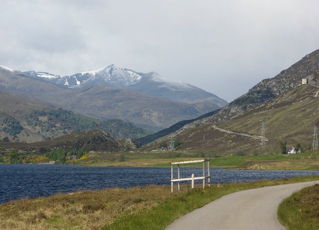
Glen Strathfarrar (Scottish Gaelic: Srath Farair) is a glen in the Highland region of Scotland, near Loch Ness.
The Glen is part of the Affric-Beauly hydro-electric power scheme, with a dam at Loch Monar and a 9 km tunnel carrying water to an underground power station at Deanie; a second dam just below Loch Beannacharan feeds a tunnel carrying water to Culligran power station (also underground). The Monar dam at Loch Monar is the largest arch dam in Britain.
The central section of Glen Strathfarrar (covering 4,027 ha (9,950 acres)) is designated as a national scenic area, one of forty such areas in Scotland, which have been defined so as to identify areas of exceptional scenery and to ensure its protection from inappropriate development. The area covered by the NSA represents the section of the glen least affected by the hydro-electric scheme, and includes the Culligran Falls.
Glen Strathfarrar is named for the River Farrar, recorded in Roman times as Varrar. The name is from *h2uer, "flowing water" (cf. the -wery- element in Tryweryn).
Other etymologies have involved an Old Pictish element *var, apparently meaning "to wind", the Latin varius with a connotation of "bending river", and an Old Celtic *vo-arar meaning "gentle river". Other hypothesizes connect Farrar with a river in modern-day France known in Latin as Arar, allegedly connected to Welsh, araf meaning "fast".
The full name is a curious 'Gaelicisation' of the Gaelic: as a strath is an elongated glen, a title of 'Glen Strath' is tautological, and it is therefore likely that an English-only speaker, ignorant of the meaning of 'Strath' when transcribing the map of the location, recorded that this was the 'Glen of Strathfarrar'.[citation needed]
The River Farrar (Scottish Gaelic: Farar / Uisge Farair) is formed as the waters of the Uisge Misgeach and the Garbh-uisge merge around 2 km after the latter exits Loch Monar. The river then adopts a sinuous course along the flat floor of the glen, running eastwards through two lochs, Loch a' Mhuillidh and Loch Beannacharan, which is dammed as part of the Affric-Beauly hydro-electric power scheme. The river then continues east, passing over Culligran Falls, before merging with the waters of the River Glass to form the River Beauly below Struy Bridge near the village of Struy.
There are a number of mountains on either side of the glen, many of which are popular with walkers. These include the Munros of Sgùrr a' Choire Ghlais, Sgurr Fhuar-thuill, Càrn nan Gobhar and Sgurr na Ruaidhe to the north, as well as Sgùrr na Lapaich, another Càrn nan Gobhar, An Riabhachan and An Socach to the south. There are also two Corbetts - Beinn a' Bha'ach Ard and Sgorr na Dìollaid.
Hub AI
Glen Strathfarrar AI simulator
(@Glen Strathfarrar_simulator)
Glen Strathfarrar
Glen Strathfarrar (Scottish Gaelic: Srath Farair) is a glen in the Highland region of Scotland, near Loch Ness.
The Glen is part of the Affric-Beauly hydro-electric power scheme, with a dam at Loch Monar and a 9 km tunnel carrying water to an underground power station at Deanie; a second dam just below Loch Beannacharan feeds a tunnel carrying water to Culligran power station (also underground). The Monar dam at Loch Monar is the largest arch dam in Britain.
The central section of Glen Strathfarrar (covering 4,027 ha (9,950 acres)) is designated as a national scenic area, one of forty such areas in Scotland, which have been defined so as to identify areas of exceptional scenery and to ensure its protection from inappropriate development. The area covered by the NSA represents the section of the glen least affected by the hydro-electric scheme, and includes the Culligran Falls.
Glen Strathfarrar is named for the River Farrar, recorded in Roman times as Varrar. The name is from *h2uer, "flowing water" (cf. the -wery- element in Tryweryn).
Other etymologies have involved an Old Pictish element *var, apparently meaning "to wind", the Latin varius with a connotation of "bending river", and an Old Celtic *vo-arar meaning "gentle river". Other hypothesizes connect Farrar with a river in modern-day France known in Latin as Arar, allegedly connected to Welsh, araf meaning "fast".
The full name is a curious 'Gaelicisation' of the Gaelic: as a strath is an elongated glen, a title of 'Glen Strath' is tautological, and it is therefore likely that an English-only speaker, ignorant of the meaning of 'Strath' when transcribing the map of the location, recorded that this was the 'Glen of Strathfarrar'.[citation needed]
The River Farrar (Scottish Gaelic: Farar / Uisge Farair) is formed as the waters of the Uisge Misgeach and the Garbh-uisge merge around 2 km after the latter exits Loch Monar. The river then adopts a sinuous course along the flat floor of the glen, running eastwards through two lochs, Loch a' Mhuillidh and Loch Beannacharan, which is dammed as part of the Affric-Beauly hydro-electric power scheme. The river then continues east, passing over Culligran Falls, before merging with the waters of the River Glass to form the River Beauly below Struy Bridge near the village of Struy.
There are a number of mountains on either side of the glen, many of which are popular with walkers. These include the Munros of Sgùrr a' Choire Ghlais, Sgurr Fhuar-thuill, Càrn nan Gobhar and Sgurr na Ruaidhe to the north, as well as Sgùrr na Lapaich, another Càrn nan Gobhar, An Riabhachan and An Socach to the south. There are also two Corbetts - Beinn a' Bha'ach Ard and Sgorr na Dìollaid.
Recent media