



Community hub
Recent from talks
Knowledge base stats:
Talk channels stats:
Members stats:
Greater Yellowstone Ecosystem
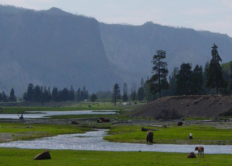
The Greater Yellowstone Ecosystem (GYE) is one of the last remaining large, nearly intact ecosystems in the northern temperate zone of Earth. It is located within the central Rocky Mountains, in areas of northwestern Wyoming, southwestern Montana, and eastern Idaho, and is about 22 million acres (89,000 km2). Yellowstone National Park and the Yellowstone Caldera 'hotspot' are within it.
The area is a flagship site among conservation groups that promote ecosystem management. It is one of the world's foremost natural laboratories in landscape ecology and Holocene geology, and is a world-renowned recreational destination. It is also home to the diverse native plants and animals of Yellowstone.
Yellowstone National Park boundaries were drawn in 1872 with the intent to include all the known geothermal basins in the region. As landscape ecology considerations were not incorporated into original boundary, revisions were suggested to conform more closely to natural topographic features, such as the ridgeline of the Absaroka Range along the east boundary. In 1929, President Hoover signed the first bill changing the park's boundaries: The northwest corner now included a significant area of petrified trees; the northeast corner was defined by the watershed of Pebble Creek; the eastern boundary included the headwaters of the Lamar River and part of the watershed of the Yellowstone River. In 1932, President Hoover issued an executive order that added more than 7,000 acres (2,800 ha) between the north boundary and the Yellowstone River, west of Gardiner. These lands provided winter range for elk and other ungulates. By the 1970s, the grizzly bear's (Ursus arctos) range in and near the park became the first informal minimum boundary of a theoretical "Greater Yellowstone Ecosystem" that included at least 4,000,000 acres (16,000 km2). Since then, definitions of the greater ecosystem's size have steadily grown larger. A 1994 study listed the size as 19,000,000 acres (76,890 km2), while a 1994 speech by a Greater Yellowstone Coalition leader enlarged that to 20,000,000 acres (80,000 km2).
In 1985, the United States Forest Service managers at Caribou–Targhee National Forest proposed harvesting 860 million board feet of timber over the coming decade, the highest harvest by far in the GYE and an extremely high proportion nationally. While they began cutting immediately, their plan was quickly challenged by a newly created Greater Yellowstone Coalition. Later that year, the United States House of Representatives Subcommittees on Public Lands and National Parks and Recreation held a joint subcommittee hearing on Greater Yellowstone, resulting in a 1986 report by the Congressional Research Service outlining shortcomings in inter-agency coordination and concluding that the area's essential values were at risk. The Congressional inquiry led to the recognition of Greater Yellowstone as a special area requiring collaboration between federal agencies.
In 1989, a Canadian mining company announced plans to open a mine on Forest Service land near Cooke City, Montana, again with the approval of the Forest Service. This was a valid claim under the General Mining Act of 1872, but drew concerned reactions from the Park Service as well as local residents. In 1995, the proposed mine was condemned by the World Heritage Committee, by President Bill Clinton, and by Montana and Wyoming politicians. The United States eventually repurchased the land for $65 million. In 2015, two new mines were proposed, leading to the passage of the Yellowstone Gateway Protection Act in 2019 to prevent all future mining claims in the GYE. Caribou–Targhee National Forest has already hosted many mines and there are over a dozen Superfund sites inside the forest boundaries. Existing mines in the GYE can also be expanded; the East Boulder Mine in Sweet Grass County, Montana received expansion approval in 2024.
Federally managed areas within the GYE include:
Ten distinct National Wilderness Areas have been established within the GYE's National Forests since 1966, mandating a higher level of habitat protection than the USFS otherwise uses.
The GYE also encompasses some privately held and state lands surrounding those managed by the U.S. Government.
Hub AI
Greater Yellowstone Ecosystem AI simulator
(@Greater Yellowstone Ecosystem_simulator)
Greater Yellowstone Ecosystem
The Greater Yellowstone Ecosystem (GYE) is one of the last remaining large, nearly intact ecosystems in the northern temperate zone of Earth. It is located within the central Rocky Mountains, in areas of northwestern Wyoming, southwestern Montana, and eastern Idaho, and is about 22 million acres (89,000 km2). Yellowstone National Park and the Yellowstone Caldera 'hotspot' are within it.
The area is a flagship site among conservation groups that promote ecosystem management. It is one of the world's foremost natural laboratories in landscape ecology and Holocene geology, and is a world-renowned recreational destination. It is also home to the diverse native plants and animals of Yellowstone.
Yellowstone National Park boundaries were drawn in 1872 with the intent to include all the known geothermal basins in the region. As landscape ecology considerations were not incorporated into original boundary, revisions were suggested to conform more closely to natural topographic features, such as the ridgeline of the Absaroka Range along the east boundary. In 1929, President Hoover signed the first bill changing the park's boundaries: The northwest corner now included a significant area of petrified trees; the northeast corner was defined by the watershed of Pebble Creek; the eastern boundary included the headwaters of the Lamar River and part of the watershed of the Yellowstone River. In 1932, President Hoover issued an executive order that added more than 7,000 acres (2,800 ha) between the north boundary and the Yellowstone River, west of Gardiner. These lands provided winter range for elk and other ungulates. By the 1970s, the grizzly bear's (Ursus arctos) range in and near the park became the first informal minimum boundary of a theoretical "Greater Yellowstone Ecosystem" that included at least 4,000,000 acres (16,000 km2). Since then, definitions of the greater ecosystem's size have steadily grown larger. A 1994 study listed the size as 19,000,000 acres (76,890 km2), while a 1994 speech by a Greater Yellowstone Coalition leader enlarged that to 20,000,000 acres (80,000 km2).
In 1985, the United States Forest Service managers at Caribou–Targhee National Forest proposed harvesting 860 million board feet of timber over the coming decade, the highest harvest by far in the GYE and an extremely high proportion nationally. While they began cutting immediately, their plan was quickly challenged by a newly created Greater Yellowstone Coalition. Later that year, the United States House of Representatives Subcommittees on Public Lands and National Parks and Recreation held a joint subcommittee hearing on Greater Yellowstone, resulting in a 1986 report by the Congressional Research Service outlining shortcomings in inter-agency coordination and concluding that the area's essential values were at risk. The Congressional inquiry led to the recognition of Greater Yellowstone as a special area requiring collaboration between federal agencies.
In 1989, a Canadian mining company announced plans to open a mine on Forest Service land near Cooke City, Montana, again with the approval of the Forest Service. This was a valid claim under the General Mining Act of 1872, but drew concerned reactions from the Park Service as well as local residents. In 1995, the proposed mine was condemned by the World Heritage Committee, by President Bill Clinton, and by Montana and Wyoming politicians. The United States eventually repurchased the land for $65 million. In 2015, two new mines were proposed, leading to the passage of the Yellowstone Gateway Protection Act in 2019 to prevent all future mining claims in the GYE. Caribou–Targhee National Forest has already hosted many mines and there are over a dozen Superfund sites inside the forest boundaries. Existing mines in the GYE can also be expanded; the East Boulder Mine in Sweet Grass County, Montana received expansion approval in 2024.
Federally managed areas within the GYE include:
Ten distinct National Wilderness Areas have been established within the GYE's National Forests since 1966, mandating a higher level of habitat protection than the USFS otherwise uses.
The GYE also encompasses some privately held and state lands surrounding those managed by the U.S. Government.