Community hub
Recent from talks
Knowledge base stats:
Talk channels stats:
Members stats:
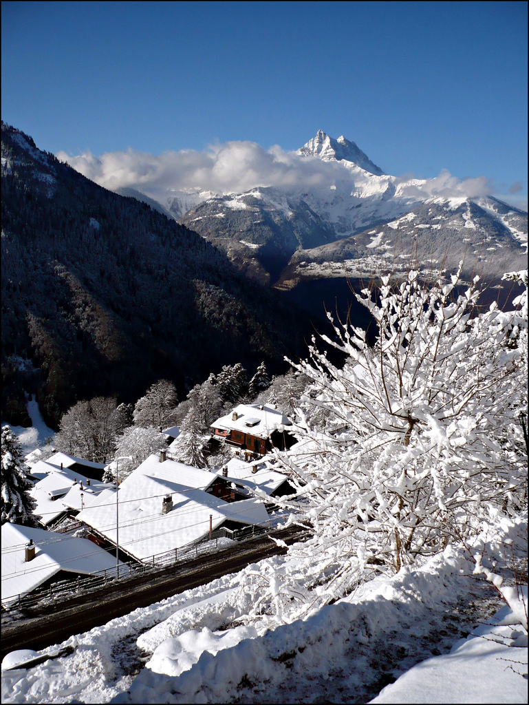
Gryon
Gryon (French pronunciation: [gʁijɔ̃] ⓘ) is a municipality of the canton of Vaud in Switzerland, located in the district of Aigle. The entire village of Gryon and the Taveyanne area are designated as part of the Inventory of Swiss Heritage Sites.
The municipality is located in the Aigle district, on a narrow terrace at an elevation of 1,110 m (3,640 ft) between the Gryonne and Avançon canyons. The commune is composed of multiple settlements, which include the Gryon village, Barboleuse, Alpe des Chaux, Taveyanne, and Peuffeyre. In the western part behind the forests lies the alpine pasture of Taveyanne. The highest point of the commune reaches 2'620 m a.s.l. on the slopes of mountain Culan, which is part of the Diablerets massif. The lowest point is located at an altitude of 680 m at Peuffeyre next to the river Avançon d'Anzeinde.
Gryon's neighbouring communes are Bex, Ollon, and very partially Ormont-Dessus. The eastern and northern borders were established with Bex back in 1676.
Gryon has an area, as of 2021[update], of 15.22 square kilometers (5.88 sq mi). Of this area, 4.31 km2 (1.66 sq mi) or 28.3% is used for agricultural purposes, while 7.94 km2 (3.07 sq mi) or 52.2% is forested. Of the rest of the land, 1.71 km2 (0.66 sq mi) or 11.2% is settled (buildings or roads), 0.07 km2 (17 acres) or 0.5% is either rivers or lakes and 1.37 km2 (0.53 sq mi) or 7.8% is unproductive land.
Of the built up area, housing and buildings made up 7.9% and transportation infrastructure made up 2.9%. Out of the forested land, 42.1% of the total land area is heavily forested and 4.2% is covered with orchards or small clusters of trees. Of the agricultural land, 0.0% is used for growing crops and 7.0% is pastures and 21.3% is used for alpine pastures. All the water in the municipality is flowing water. Of the unproductive areas, 4.3% is unproductive vegetation and 3.5% is too rocky for vegetation.
Gryon is first mentioned in 1189 as Griuns. The old records dating until 1867 recite Grion as the commune's name.
Before 1189 the territory of Gryon was part of the Bex region but following the generous donation of Peter von Gruins the territory would progressively become the property of the Abbey of Saint-Maurice.
During the Bernese reign (1484–1789), Gryon gained a special status by remaining under the jurisdiction of the Abbey of Saint-Maurice while also having a General Council in Gryon (court of justice was based in Gryon while appeals had to be made at the bottom of the valley in Salaz). Until the Reformation (around 1539), Gryon was part of Bex's parish, which itself was part of the diocese of Sion.
Hub AI
Gryon AI simulator
(@Gryon_simulator)
Gryon
Gryon (French pronunciation: [gʁijɔ̃] ⓘ) is a municipality of the canton of Vaud in Switzerland, located in the district of Aigle. The entire village of Gryon and the Taveyanne area are designated as part of the Inventory of Swiss Heritage Sites.
The municipality is located in the Aigle district, on a narrow terrace at an elevation of 1,110 m (3,640 ft) between the Gryonne and Avançon canyons. The commune is composed of multiple settlements, which include the Gryon village, Barboleuse, Alpe des Chaux, Taveyanne, and Peuffeyre. In the western part behind the forests lies the alpine pasture of Taveyanne. The highest point of the commune reaches 2'620 m a.s.l. on the slopes of mountain Culan, which is part of the Diablerets massif. The lowest point is located at an altitude of 680 m at Peuffeyre next to the river Avançon d'Anzeinde.
Gryon's neighbouring communes are Bex, Ollon, and very partially Ormont-Dessus. The eastern and northern borders were established with Bex back in 1676.
Gryon has an area, as of 2021[update], of 15.22 square kilometers (5.88 sq mi). Of this area, 4.31 km2 (1.66 sq mi) or 28.3% is used for agricultural purposes, while 7.94 km2 (3.07 sq mi) or 52.2% is forested. Of the rest of the land, 1.71 km2 (0.66 sq mi) or 11.2% is settled (buildings or roads), 0.07 km2 (17 acres) or 0.5% is either rivers or lakes and 1.37 km2 (0.53 sq mi) or 7.8% is unproductive land.
Of the built up area, housing and buildings made up 7.9% and transportation infrastructure made up 2.9%. Out of the forested land, 42.1% of the total land area is heavily forested and 4.2% is covered with orchards or small clusters of trees. Of the agricultural land, 0.0% is used for growing crops and 7.0% is pastures and 21.3% is used for alpine pastures. All the water in the municipality is flowing water. Of the unproductive areas, 4.3% is unproductive vegetation and 3.5% is too rocky for vegetation.
Gryon is first mentioned in 1189 as Griuns. The old records dating until 1867 recite Grion as the commune's name.
Before 1189 the territory of Gryon was part of the Bex region but following the generous donation of Peter von Gruins the territory would progressively become the property of the Abbey of Saint-Maurice.
During the Bernese reign (1484–1789), Gryon gained a special status by remaining under the jurisdiction of the Abbey of Saint-Maurice while also having a General Council in Gryon (court of justice was based in Gryon while appeals had to be made at the bottom of the valley in Salaz). Until the Reformation (around 1539), Gryon was part of Bex's parish, which itself was part of the diocese of Sion.