Hubbry Logo
Guinea HighlandsGuinea HighlandsMain
Open search
Guinea Highlands
Community hub
Guinea Highlands
logo
8 pages, 0 posts
0 subscribers
Be the first to start a discussion here.
Guinea Highlands
Guinea Highlands
from Wikipedia
Map of the Guinea Highlands

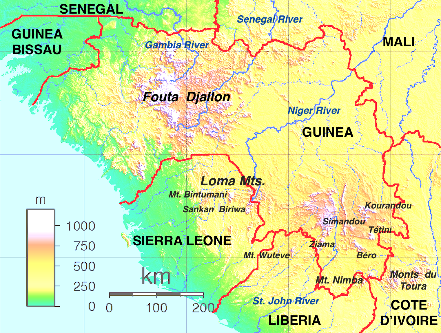
The Guinea Highlands is a densely forested mountainous plateau extending from central Guinea through northern Sierra Leone and Liberia to western Ivory Coast. The highlands include a number of mountains, ranges and plateaus, including the Fouta Djallon highlands in central Guinea, the Loma Mountains in Sierra Leone, the Simandou and Kourandou massifs in southeastern Guinea, the Nimba Range at the border of Guinea, Liberia, and Ivory Coast, and the Monts du Toura in western Ivory Coast.

Geography

[edit]
Mount Nimba Strict Nature Reserve

In Guinea they are known as Dorsale Guinéenne. The highest peak in the region is Mount Bintumani in Sierra Leone, at 1,945 metres (6,381 ft). Other peaks include Sankan Biriwa (1,850 metres (6,070 ft)) in Sierra Leone and Mount Richard-Molard (Mount Nimba) (1,752 metres (5,748 ft)) on the border of Guinea and Ivory Coast. The highlands mostly lie between 300 and 500 metres (980 and 1,640 ft) above sea level.[1]

The Guinea Highlands are the source of many of West Africa's rivers, including the Niger River, West Africa's longest river, the Senegal and Gambia rivers, and the rivers of Sierra Leone, Liberia, Maritime Guinea, and western Ivory Coast.

Geology

[edit]
Nimba Mountain Nature Reserve in the Nimba Range, which is a mountain range in the Guinea Highlands.

Geologically the composition of the sediments in the highlands are the same as in Upper Guinea and include granites, schists, and quartzites.[2]

Ecology

[edit]
Landscape in the neighbourhood of Mount Nimba, Guinea

The Guinea Highlands form the transition between the Western Guinean lowland forests, moist tropical rainforests that lie to the south between the Guinea Highlands and the Atlantic Ocean, and the Guinean forest-savanna mosaic to the north.

The Guinean montane forests ecoregion covers the portion of the highlands above 600 meters elevation. It includes montane forests, grasslands, and savannas, with a distinct flora and fauna from the surrounding lowlands.

People

[edit]

Yomou is the chief market town for the densely forested region of the Guinea Highlands. Main commodities sold in the town include rice, cassava, coffee, palm oil and kernels.[3] The region is mainly inhabited by the Guerze (Kpelle) and Mano (Manon) peoples.

Peaks

[edit]
Mount Bintumani (1945 m).
Mount Nimba (1752 m), which is also known as Mount Richard-Molard.
  • Mount Bintumani (Loma Mansa), Sierra Leone, 1945 meters (6381 feet)
  • Sankan Biriwa, Sierra Leone, 1,850 metres (6,070 ft)
  • Mount Richard-Molard, also known as Mount Nimba, Ivory Coast and Guinea, 1752 meters (5748 feet)
  • Grand Rochers, Guinea, 1694 meters (5558 feet)
  • Mont Sempéré, Guinea, 1682 meters (5518 feet)
  • Mont Tô, Guinea, 1675 meters (5495 feet)
  • Mont Piérré Richaud, Guinea, 1670 meters (5479 feet)
  • Pic de Fon, Guinea, 1658 meters (5440 feet)
  • Mont LeClerc, Guinea, 1577 meters (5174 feet)
  • Pic de Tibé, Guinea, 1504 meters (4934 feet)
  • Mount Wuteve, Liberia, 1420 meters (4659 feet)
  • Pic de Tétini, Guinea 1257 meters
  • Kourandou Massif, Guinea, 1236 meters
  • Béro Massif, Guinea, 1210 meters

References

[edit]
Revisions and contributorsEdit on WikipediaRead on Wikipedia
from Grokipedia
The Guinea Highlands, also known as the Guinean Highlands, is a rugged mountainous plateau in , primarily located in central and southeastern but extending into northern , , western Côte d'Ivoire, southern , and . This region, characterized by high plateaus, dissected valleys, and peaks rising to 1,948 meters at Mount Bintumani in Sierra Leone's Loma Mountains, serves as the hydrological heart of , originating major rivers including the (4,180 km long), , and . The highlands' terrain includes notable features such as Guinea's massif, the Nimba Mountains straddling international borders, and the in , with elevations generally between 600 and 1,500 meters across much of the area. The climate is predominantly humid tropical, with annual rainfall ranging from 1,200 to 4,000 mm concentrated in a from May to , moderated by the region's altitude that reduces temperatures compared to lowland areas. Dry winds from the northeast prevail during the December-to-May dry season, occasionally leading to periodic droughts that affect water flow downstream. Ecologically, the Guinea Highlands form part of the Upper Guinean ecosystem, a global biodiversity hotspot supporting dense tropical evergreen rainforests, moist deciduous , montane woodlands, and gallery along rivers, with high levels of among and fauna including , chimpanzees, and elephants. However, the region has experienced severe , with approximately 84% of its original lost by 1975 due to slash-and-burn agriculture, , and , leaving only about 71,000 square kilometers of as of 2013, of which 32,000 square kilometers are protected. The highlands' significance extends beyond , as they underpin through fertile soils in valleys and plateaus supporting crops like , , and , while their water resources sustain millions across via the originating rivers that flow through multiple nations. Conservation challenges persist amid ongoing and human expansion, with protected areas like the Ziama Biosphere Reserve in playing a crucial role in preserving remaining habitats.

Geography

Location and Extent

The Guinea Highlands, a prominent in , span approximately 7°–12°N and 8°–13°W longitude, encompassing central and southeastern as its core area. This elevated terrain covers approximately 80,000 km² (31,000 square miles), forming a transitional zone between the landscapes to the north and the tropical forests to the south. The region extends across multiple countries, including central and southeastern , northern (particularly the Loma-Man Highlands), northeastern (Nimba Mountains), and western d'Ivoire (Man Mountains), influencing cross-border ecological and hydrological systems. As a southern extension of the highlands—primarily a tableland confined to with minor foothills in and —the Guinea Highlands represent a broader upland system that rises to 1,000–2,000 meters above , serving as a critical divide for regional river basins. The term "Guinea Highlands" emerged in the 19th century through descriptions by European explorers mapping the elevated interior of , distinguishing it from coastal lowlands and northern savannas during expeditions that documented the region's role in major river origins.

Topography and Peaks

The Highlands form a rugged mountainous region in , characterized by a high plateau system that spans southeastern , northern , , and adjacent areas of Côte d'Ivoire, featuring peaks, ridges, plateaus, valleys, cliffs, and outcrops shaped by long-term processes. Elevations in the region generally exceed 1,000 meters, with the plateau averaging around 1,000 meters in associated highland areas like the extension, rising to summits over 1,500 meters and creating steep escarpments and dissected valleys. This topography includes lateritic plateaus capped by hardened ferruginous soils, such as those in the Bowé region, interspersed with isolated massifs and inselbergs that contribute to the area's topographic diversity. Major landforms within the Guinea Highlands include the Nimba Range, which straddles the borders of , , and Côte d'Ivoire, rising abruptly from surrounding lowlands to form a prominent with steep slopes and ridges. The Loma Mountains in northern represent another key feature, consisting of forested uplands and granitic that extend the highland plateau eastward. The Badiar Plateau, located in northwestern near the border, adds to the regional plateau morphology as an elevated plain with incised streams and moderate slopes, though at lower elevations compared to the southern . Prominent peaks in the Guinea Highlands highlight its elevational extremes, with Mount Bintumani (also known as Loma Mansa) in the Loma Mountains standing as the highest at 1,948 meters, marking the summit of . Mount Nimba, the range's namesake massif, reaches 1,752 meters at Mont Richard-Molard, its highest point shared across the Guinea-Liberia-Côte d'Ivoire border and serving as Guinea's tallest peak. Other notable summits include Mount Wuteve at 1,380 meters in Liberia's portion of the highlands and the Ziama Massif, which tops out at approximately 1,400 meters in , exemplifying the isolated, erosion-carved elevations that define the region's skyline. These peaks and their surrounding landforms underscore the Guinea Highlands' role as a fragmented upland mosaic, where plateaus transition into dramatic vertical relief over millions of years of and fluvial incision.

Hydrology

The Guinea Highlands, particularly the massif, serve as the primary watershed for several major rivers in , earning the region the designation of the "water tower of " due to its role in originating and sustaining these vital watercourses. This elevated terrain channels precipitation into river systems that support , , and ecosystems across multiple countries, with the highlands hosting the headwaters of transboundary basins that collectively drain over 1 million square kilometers. Key rivers originating from the Guinea Highlands include the upper Niger River, whose source lies in the Fouta Djallon near the town of Faranah, feeding the expansive Niger Basin that spans nine countries. The Senegal River's headwaters also emerge here, with the Bafing and Bakoye tributaries rising in the highlands and converging to form the main stem, while the Gambia River begins in the same region, flowing westward through Gambia and Senegal. In the southern sectors, coastal basins receive drainage from rivers such as the Moa and St. Paul (Great Scarcies), which originate in the southeastern highlands and flow toward the Atlantic Ocean, contributing to local hydrological networks rather than distant inland systems like the Volta. The region's hydrology features numerous waterfalls, such as those along the upper and coastal , which harness significant hydroelectric potential due to steep gradients and high seasonal flows. Seasonal are prevalent, with many smaller rivers experiencing intermittent flow during the , leading to periodic drying in headwater areas influenced by variable rainfall patterns. aquifers are primarily hosted in the weathered and fractured layers of the underlying basement rocks, including granites and gneisses, where secondary from processes allows for storage and recharge, though overall yields remain moderate due to the predominantly low-permeability crystalline . Annual discharge from highland-sourced rivers underscores their regional importance; for instance, the 's total basin outflow averages approximately 180 cubic kilometers per year at its mouth, with a substantial portion originating from the Guinea Highlands' contributions in the upper reaches. This volume supports downstream and but is subject to interannual variability, highlighting the highlands' critical influence on West African .

Geology

Formation and Structure

The Guinea Highlands constitute a portion of the Man Shield, the southern domain of the West African Craton, assembled during the Eburnean between approximately 2.2 and 1.8 billion years ago. This orogenic event involved the collision and accretion of cratonic nuclei, such as the Leo and Man domains, resulting in extensive to amphibolite , granitic plutonism, and deformation that cratonized the region through continental convergence. The tectonic framework of the highlands reflects a stable cratonic shield with minimal seismic activity, owing to the rigid, thickened lithosphere characteristic of shields. Following Eburnean stabilization, the area experienced peripheral reactivation during the around 600 million years ago, as convergent tectonics in adjacent belts like the Rokelides induced regional epeirogenic uplift along margins. tectonism contributed further uplift exceeding 1 km in areas like the . Key structural elements include fault lines and thrust systems, notably along the Nimba Range, where imbricate thrusts and mylonitic shear zones demarcate terrane boundaries between supracrustal sequences and basement gneisses. Horst-graben configurations, arising from extensional faulting superimposed on earlier compressional fabrics, facilitated the development of prominent escarpments by differential uplift of resistant blocks. In the evolutionary timeline, denudation since the has profoundly shaped the landscape, eroding more than 1 km of relief through fluvial incision and lateritic weathering cycles to the present averaging 800–1,500 m.

Rock Composition and Resources

The Guinea Highlands are underlain by the Archean-Proterozoic complex of the West African Craton, consisting primarily of granitic intrusions, schists, gneisses, and quartzites that form the region's stable crystalline foundation. These rocks, dating back over 1.6 billion years with some elements as old as 2.5 billion years, exhibit north-northeast trending structures and have been exposed through tectonic events that uplifted the cratonic margins. The area is endowed with significant mineral resources, including high-grade iron ore deposits in the Nimba Mountains with JORC-compliant reserves of approximately 54 million tons grading 61.6% Fe (as of 2015), as well as , , , , and traces of . occurs extensively in the plateau, formed through intensive lateritic , while alluvial and are prevalent in river valleys, and deposits are scattered across the cratonic . Intense tropical of the quartzites and other rocks has produced lateritic soils, which are nutrient-poor due to leaching of silica and bases but support adapted and through their and aluminum content. concentrations are notably dense in southeastern and adjacent , particularly at Mount Nimba and Simandou, whereas is more widespread across central Guinea's plateaus, and alluvial gold is distributed along major river systems draining the highlands.

Climate

Regional Climate Patterns

The Guinea Highlands feature a under the Köppen classification (Am), marked by high humidity levels and a seasonal rainfall regime with a single main that supports the region's role as a major water source for West African systems. This classification reflects the dominance of warm, moist air masses from the Atlantic, fostering consistent atmospheric moisture conducive to frequent and , particularly in elevated areas. Annual temperature averages in the region span 24–28°C at elevations below 1,000 m, decreasing to 18–22°C at higher altitudes due to the cooling influence of , with diurnal fluctuations reaching up to 10°C but limited annual variation of less than 5°C. These stable thermal conditions stem from the equatorial proximity and moderating effects of persistent cloudiness, which dampens extremes compared to surrounding lowlands. Precipitation totals range from 1,500 to 2,500 mm annually across the highlands, driven primarily by the seasonal northward and southward migration of the (ITCZ), which brings convergent moist winds from the southwest. Orographic uplift amplifies this pattern, creating microclimatic gradients where windward slopes receive enhanced rainfall; for instance, the Nimba Range experiences up to 3,000 mm due to forced ascension of Atlantic moisture over the terrain.

Seasonal Variations and Impacts

The Guinea Highlands experience a pronounced from May to , driven by the influx of moist air from the Atlantic monsoons, which deliver heavy rainfall averaging 200–400 mm per month and result in high levels of 80–90%. This period accounts for approximately 80% of the region's annual precipitation, reaching 1,500–2,000 mm in total, leading to widespread flooding in low-lying areas and swollen rivers that serve as vital water sources for downstream West African basins. The intense downpours, amplified by the highlands' , contribute significantly to , with runoff coefficients reaching up to 0.65 in some basins, stripping and altering landscapes. In contrast, the spans November to April, characterized by the winds originating from the , which bring fine dust particles, markedly reduced rainfall below 100 mm per month, and lower humidity that can drop to 20–40%. Nighttime temperatures in the highlands cool to 15–20°C during this period, providing relief from daytime highs of 25–30°C, though the arid conditions exacerbate stress on and . These seasonal shifts directly influence agricultural cycles, as rainfed farming—dominant in the region—concentrates planting and harvesting in the wet months, while dry periods limit and heighten crop failure risks for staples like and rice. Additionally, disease patterns fluctuate, with transmission peaking during the wet season due to standing water breeding vectors, particularly affecting rural communities. Long-term climate trends, observed through 2025, reveal a recovery in rainfall since the 1990s in core highland areas, attributed to shifting dynamics under . This intensification has heightened hydrological impacts, including more frequent and severe landslides, as evidenced by events in 2025 triggered by extreme downpours that caused over 50 deaths across and damaged infrastructure. Overall temperatures in the region average 23–28°C annually, with seasonal variations building on these baselines. Projections as of 2025 indicate potential increases in rainfall intensity and temperatures by 1–3°C by mid-century, further stressing and .

Ecology

Ecosystems and Vegetation

The Guinea Highlands, encompassing the Fouta Djallon massif and surrounding plateaus in , feature distinct ecoregions shaped by elevation and rainfall patterns. The upper elevations above 600 meters fall within the Guinean Montane Forests ecoregion, characterized by isolated peaks and plateaus that support cloud forests transitioning into montane grasslands and . Lower slopes, below 600 meters, integrate with the Western Guinean Lowland Forests ecoregion, where moist evergreen forests prevail amid a mosaic of savanna elements. These ecoregions host over 9,000 species across the broader Guinean Forests hotspot, with approximately 20% , reflecting the region's role as a refuge. Vegetation in the Guinea Highlands exhibits diverse types adapted to topographic and climatic gradients. Evergreen rainforests dominate the lower and mid-elevations, featuring tall emergents such as African mahogany (Khaya ivorensis) and (Lophira alata), alongside understories of epiphytes and ferns in humid, shaded environments. In montane zones, vegetation shifts to mixed forests with ericaceous shrubs from the family , including species like Erica spp., and dense bamboo thickets (Oxytenanthera abyssinica), which form impenetrable stands on steeper slopes. Higher plateaus include open montane grasslands and mosaics, where fire-adapted grasses such as Andropogon and Hyparrhenia species create expansive, tussock-dominated landscapes interrupted by gallery forests along watercourses. Altitudinal zonation structures these plant communities across the highlands' elevation range of 300 to over 1,500 meters. From 300 to 600 meters on the lower slopes, moist lowland forests prevail with semi-evergreen canopies and diverse tree layers. Between 600 and 1,200 meters, mid-elevation mixed forests incorporate montane elements, blending broadleaf trees with shrubs and increasing presence. Above 1,500 meters on the highest plateaus, subalpine grasslands emerge, dominated by herbaceous perennials and scattered shrubs resilient to cooler temperatures and periodic fires. This stratification supports habitat transitions influenced by orographic rainfall, with montane areas receiving up to 2,000 mm annually. Key plant species highlight the region's uniqueness, particularly endemics confined to montane habitats. The Guinean Montane Forests harbor about 35 endemic vascular plants, including 11 paleoendemics, such as Parinari excelsa and Gaertnera paniculata in canopies on peaks like Mount Nimba. In the Loma Mountains, representative endemics include Anthonotha macrophylla and Allanblackia floribunda, contributing to the structural diversity of mid-elevation forests. mosaics feature fire-resilient grasses like Hyparrhenia rufa, which regenerate rapidly post-burn, maintaining open landscapes essential for ecological connectivity. These species underscore the highlands' evolutionary significance within the archipelago.

Biodiversity and Endemism

The Guinea Highlands, encompassing montane forests and grasslands primarily in Guinea, Sierra Leone, Liberia, and Côte d'Ivoire, form a critical component of the Guinean Forests of West Africa biodiversity hotspot, renowned for its exceptional faunal richness driven by topographic isolation and diverse microhabitats. This region supports a significant portion of the hotspot's vertebrate diversity, including over 300 mammal species across the broader Upper Guinean forests, with key populations in highland areas like the Nimba Mountains. Bird communities exceed 900 species regionally, while amphibian assemblages surpass 250 species, many adapted to the humid, elevated environments that foster speciation. Mammalian diversity in the Guinea Highlands is particularly notable, featuring over 100 species in localized areas such as Mount Nimba, including charismatic megafauna like western chimpanzees (Pan troglodytes verus), known for tool-using behaviors in highland caves. Avian richness includes more than 400 species in the Nimba range alone, with forest-dependent groups such as turacos (Tauraco spp.) thriving in the canopy layers of mid-elevation forests. faunas exhibit high diversity, with over 50 frog species documented in highland wetlands and streams, reflecting the region's role as a refuge for moisture-loving taxa amid varying altitudes. Endemism is pronounced in the Guinea Highlands due to orographic barriers that promote isolated , with Mount Nimba serving as a focal point for unique taxa. The Mount Nimba viviparous toad (Nimbaphrynoides occidentalis), a critically endangered endemic to highland meadows above 1,200 meters, represents a remarkable evolutionary adaptation as one of the few live-bearing frogs, gestating young internally before birth. Similarly, the Nimba otter shrew (Micropotamogale lamottei), a semi-aquatic restricted to streams in the Nimba Mountains' mid-elevation forests, preys on aquatic invertebrates and exemplifies narrow-range within the Upper Guinean . Floral and faunal endemics extend to approximately 16 strictly endemic vascular plants and several insect species confined to the highlands' unique habitats, underscoring the area's biogeographic distinctiveness. As part of the Guinean Forests hotspot, the Guinea Highlands contribute to a assemblage exceeding 9,000 , with about 20% (roughly 1,800) endemic, many concentrated in montane zones that support specialized and epiphytic growth. This hotspot status highlights the region's global significance, harboring over 60 endemic mammals, 49 endemic birds, and more than 118 endemic amphibians across its expanse, with highland isolates amplifying local rates. Ecological dynamics in the Guinea Highlands are shaped by , such as African forest elephants (Loxodonta cyclotis), which facilitate of large-fruited trees over distances up to 65 kilometers, maintaining forest composition and regeneration in fragmented highland habitats. Migratory birds, including nearly 100 Palearctic species that passage through Upper Guinean forests, utilize the highlands as stopover sites along intra-African and trans-Saharan routes, enhancing nutrient cycling and services.

Conservation Challenges

The Guinea Highlands face significant conservation challenges primarily from deforestation, mining activities, and climate change, which threaten its unique montane ecosystems and biodiversity. Deforestation occurs at an estimated annual rate of 1-2% in the region's forests, driven by agricultural expansion and logging, leading to habitat fragmentation and soil erosion. Mining, particularly iron ore extraction near Mount Nimba, pollutes waterways through sediment runoff and chemical contamination, degrading aquatic habitats and downstream ecosystems. As of 2025, proposed iron ore mining expansions near Mount Nimba continue to threaten the reserve's integrity through habitat disruption and pollution. Climate-induced shifts, including altered rainfall patterns and rising temperatures, are causing upward migration of species and potential loss of high-altitude refugia, exacerbating vulnerability in this biodiversity hotspot. Protected areas play a crucial role in mitigating these threats, with the Mount Nimba Strict Nature Reserve serving as a flagship site spanning Guinea and Côte d'Ivoire, covering 17,540 hectares (12,540 hectares in Guinea) and designated a World Heritage Site in 1982. This reserve protects montane grasslands and forests but contends with encroachment from surrounding land uses. Similarly, the Loma Mountains National Park in encompasses approximately 33,200 hectares, safeguarding massifs and diverse habitats while facing pressures from and . These areas represent key efforts to preserve the highlands' ecological integrity amid regional development. Conservation initiatives emphasize transboundary cooperation, such as the Ecosystem Conservation and International Management Project, which involves , , , and Côte d'Ivoire to establish corridors and sustainable across shared highlands landscapes. Post-2020 reforestation efforts, including community-led projects in 's forested regions, planted 125,000 trees in targeted areas in 2020, with goals to restore degraded lands and enhance . These programs involve local communities and international partners to counter habitat loss. The cumulative impacts have resulted in an estimated 85% loss of native vegetation in the Upper Guinean Forests since the mid-20th century, contributing to heightened risks for endemic . More than 10 in the highlands, including the critically endangered and endangered Jentink's , are classified as IUCN-threatened, underscoring the urgency of ongoing protective measures.

History

Pre-Colonial Era

Evidence of human presence in , including regions near the Guinea Highlands, dates back to the , with archaeological sites around 10,000–13,000 BCE indicating groups utilizing diverse landscapes for and early resource exploitation. Findings, including stone tools and settlement remnants, suggest small-scale occupations adapted to highland plateaus and forested areas, marking the onset of sustained human activity in this part of . These early inhabitants likely navigated the ecological transitions from to montane forests, laying the groundwork for later cultural developments. By around 1,000 BCE, the arrival of Niger-Congo-speaking groups, including precursors to Bantu-related expansions from the Cameroon-Nigeria borderlands, introduced ironworking to , with the technology spreading to the Guinea Highlands through migration and diffusion. This innovation enabled the production of stronger tools for clearing vegetation and tilling , transforming subsistence patterns and facilitating . Evidence of early iron in dates to around 800–400 BCE, with furnaces and deposits providing direct evidence of these metallurgical practices during the early . During the 8th to 15th centuries, the Guinea Highlands formed a peripheral yet vital component of the and Empires' economic spheres, primarily through routes that funneled gold from mines in the upper and basins—with highland regions contributing through trade routes—to northern markets in exchange for salt, cloth, and copper. Local societies, including decentralized forest chiefdoms of the Kissi in southeastern and northern , and the Kpelle in central and , maintained autonomous political structures centered on networks and , often engaging in tribute-based relations with imperial centers without full subjugation. These chiefdoms controlled access to forest resources and sites, contributing to the empires' wealth while preserving regional independence. Cultural life in the pre-colonial Guinea Highlands revolved around oral traditions that emphasized ancestor worship, with elders reciting genealogies and myths to reinforce communal identity and spiritual connections to the land. Agricultural practices evolved significantly, with yam cultivation—centered on species like Dioscorea rotundata—becoming a cornerstone, as the crop's tubers thrived in the nutrient-rich, well-drained highland soils under slash-and-burn systems that promoted . Archaeological evidence, such as rock paintings in northern , illustrates communal rituals, hunting scenes, and symbolic motifs, reflecting a intertwined with and ancestry. These elements fostered resilient societies capable of sustaining and amid the highlands' challenging terrain.

Colonial and Post-Colonial Developments

The colonization of the Highlands intensified in the late as European powers sought to exploit the region's natural resources and strategic position. French forces, under the direction of explorers like Louis-Gustave Binger, penetrated the highlands from the coast, establishing administrative control over present-day and northern d'Ivoire by the 1890s through military expeditions and treaties with local leaders. British influence dominated in , where colonial authorities extended operations into the eastern highland fringes bordering , an independent republic founded by freed American slaves in 1847 but economically intertwined with British trade networks. Early resource extraction focused on rubber and timber concessions granted to European companies, with French firms establishing plantations in the fertile highland valleys, disrupting local agrarian systems and initiating forced labor practices. The of 1884–1885 formalized the partition of , assigning the Guinea Highlands to French and British spheres without regard for ethnic or geographic cohesion, resulting in arbitrary borders that fragmented highland communities and facilitated colonial resource claims. This division accelerated infrastructure development, such as roads and railways linking highland mines to coastal ports, but primarily served extraction purposes, with timber and rubber exports peaking in the early under monopolistic concessions. Pre-colonial trade networks, which had connected highland producers to Sahelian markets, were largely supplanted by these colonial economies. Waves of independence reshaped the region in the late 1950s and , with rejecting the in a 1958 referendum to become the first independent French-speaking African state, followed by Côte d'Ivoire in 1960 and in 1961; Liberia's long-standing sovereignty influenced regional dynamics but did not prevent tensions. These transitions sparked post-independence border tensions. Post-independence leaders, notably 's , pursued policies in the and 1970s, seizing control of and mines from foreign operators; for instance, the state acquired a 49% stake in the Fria bauxite facility by the mid-1970s, redirecting revenues toward domestic development amid economic isolation from former colonizers. The civil wars in (1989–2003) and (1991–2002) brought devastation to the Guinea Highlands, as rebel groups exploited porous borders for arms and resources, leading to cross-border raids and the influx of over 450,000 refugees into southeastern 's highland districts by the late . These conflicts displaced highland communities, destroyed timber stands and agricultural lands, and prompted Guinean military incursions into Sierra Leonean territory, exacerbating humanitarian crises with reports of civilian killings and forced recruitment near the borders. In the , the Economic Community of West African States () has advanced regional cooperation on resource management, establishing protocols in the 2000s for joint monitoring of transboundary in the Guinea Highlands. The 2014–2016 outbreak further exposed the highlands' isolation, with the virus originating in Guinea's forested border regions and spreading due to limited road access and distrust of outsiders, resulting in over 28,000 cases across the subregion and delaying aid delivery to remote highland villages. Since 2016, the region has faced ongoing challenges from large-scale mining projects, such as the Simandou development in southeastern , which has raised concerns over environmental impacts and community displacement in the highlands. The 2021 military coup in , led by Colonel , has influenced resource governance, leading to renewed foreign investments in and iron while sparking debates on and local benefits as of 2025.

People and Society

Ethnic Groups and Demographics

The Guinea Highlands, a transboundary region extending across central and southeastern , northern , , western Côte d'Ivoire, southern , southern , and southwestern , are home to an estimated 5–7 million people as of 2025, reflecting across its rugged terrain. In the core areas of central , northern , and northeastern , population density remains low at 20–50 people per square kilometer, constrained by the area's mountainous landscape and limited suitable for large-scale settlement. This sparse distribution is characteristic of the plateau's environmental challenges, including steep slopes and seasonal flooding in lower valleys. The region's ethnic composition is diverse, with major groups varying by subregion. In the western core, it is dominated by several groups that each constitute 10–20% of local populations in their core areas. The Kpelle (also known as Guerze), the largest group straddling the -Liberia border, are primarily subsistence farmers adapted to the forested highlands. The Loma, concentrated along the - frontier, maintain traditional agrarian lifestyles in the northern extensions of the range. Other prominent groups include the Mano in Liberia's portions, the Kissi distributed across and , all contributing to the mosaic of Mande and Atlantic language speakers in the southern highlands. These groups reflect historical migrations that have shaped the demographic landscape. In the eastern extensions, such as Nigeria's , indigenous groups include the Berom, Afizere (Jarawa), and Ngas, who inhabit the higher plateaus and engage in farming and herding. Demographic trends in the Guinea Highlands feature a rural majority, with approximately 80% of residents living in countryside settings focused on , and a pronounced youth bulge where over 60% of the is under 25 years old. This youthful profile underscores high fertility rates and limited , with from surrounding lowlands drawn by opportunities in highland farming, particularly and cultivation on terraced slopes. Settlement patterns emphasize scattered villages perched on plateaus and hilltops for defense and water access, interspersed with emerging urban centers such as Nzérékoré in 's Forest Region ( around 200,000) and Yekepa in , the latter developed near mines. These patterns highlight the interplay between natural and economic pull factors in sustaining low-density habitation.

Culture and Languages

The Guinea Highlands are home to a rich linguistic diversity, with over 20 indigenous languages spoken across the region spanning , , , and Côte d'Ivoire. These primarily belong to the Mande and Kru language families, reflecting the ethnic mosaic of highland communities. Among the , Kpelle is the most widely spoken, with approximately 1.3 million speakers in and , serving as a in central and adjacent Guinean areas. Mande subgroups include Loma, spoken by around 350,000 people in the border regions of and , and Mano, used by communities in northeastern and southeastern . French serves as the in , while English holds that status in and , facilitating administration and education amid the indigenous tongues. Traditional cultural practices in the highlands emphasize animist beliefs, where communities revere a High God alongside lesser spirits, ancestors, and natural forces like nyama, often honored through rituals at sacred groves and forests that hold ecological and spiritual significance. Initiation rites form a cornerstone of social life, particularly through men's secret societies such as , which guide young males into adulthood via multi-year ceremonies involving secret languages, ritual scarring, and moral education in secluded forest groves. Music plays a vital role in these practices, with instruments like the kora (a 21-string harp-lute) and (a wooden with gourd resonators) accompanying oral epics recited by griots, who preserve historical and moral narratives tied to community identity. Highland arts and festivals express spiritual and communal themes, featuring wood carvings and masks that depict ancestral spirits and protective figures, often crafted by specialized artisans among groups like the Kissi for use in rituals and dances. Annual harvest festivals celebrate staple crops such as yam and , with events like the Gbagba among farming communities involving communal feasts, dances, and music to give thanks for bountiful yields and reinforce social bonds. Modern influences have led to a blending of traditions with and , to which 40–50% of highland populations adhere, often syncretizing animist elements like ancestor veneration with Islamic brotherhoods or Christian practices. and economic shifts pose challenges to preservation, eroding some communal rituals through migration to cities, yet efforts by cultural troupes and national initiatives continue to adapt and sustain oral traditions amid these changes.

Economy and Human Impacts

The economy of the Guinea Highlands is predominantly agrarian, with forming the backbone of livelihoods for the majority of the population. In 's region, which constitutes a significant portion of the highlands, farming employs over half of the and supports approximately 52% of rural households through the cultivation of staple crops such as , , , and , alongside cash crops like , cocoa, and oil palm. These activities, often conducted on small plots using traditional methods, account for a substantial share of security and income, though productivity remains low due to limited access to modern inputs and markets. Small-scale artisanal mining, particularly for gold, supplements agricultural incomes across the highlands, drawing migrants and informal workers to alluvial sites in areas like the and Siguiri basin. Industrial extraction has grown, notably with large-scale operations in the Nimba Mountains straddling and ; ArcelorMittal Liberia's expansions in reached a production capacity of up to 20 million tons per year by 2025, tripling prior output levels and positioning the region as a key exporter. Timber harvesting and exports also contribute, though on a smaller scale regionally, with 's overall wood product shipments valued at tens of millions annually amid broader West African trends. Human activities have exerted significant environmental and social pressures on the highlands. Slash-and-burn farming practices, prevalent in , have led to widespread soil degradation through erosion and nutrient depletion, exacerbating land productivity losses in the where and compound the issue. Mining operations have caused community displacements and social tensions in areas like the Nimba Mountains due to land acquisition and resettlement issues. Development challenges persist, including severe infrastructure deficits such as limited road networks that hinder market access and economic integration in remote highland areas. Poverty rates remain high, with rural populations in Guinea facing incidences around 63%, twice the urban rate, driven by low agricultural yields and weak linkages to extractive sectors. Ecotourism offers untapped potential, particularly through guided hikes in the Nimba Mountains, where community-based initiatives could generate sustainable revenue while supporting conservation, though current contributions are modest compared to mining outputs.

References

Add your contribution
Related Hubs
User Avatar
No comments yet.