Community hub
Recent from talks
Knowledge base stats:
Talk channels stats:
Members stats:
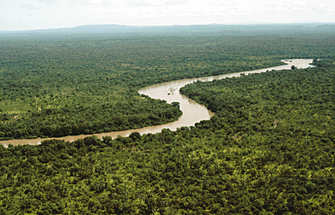
Gambia River
The Gambia River (formerly known as the River Gambra, French: Fleuve Gambie, Portuguese: Rio Gâmbia) is a major river in West Africa, running 1,120 kilometres (700 mi) from the Fouta Djallon plateau in north Guinea westward through Senegal and The Gambia to the Atlantic Ocean at the city of Banjul. It is navigable for about half that length.
The river is strongly associated with The Gambia, the smallest country in mainland Africa, which occupies the downstream half of the river and its two banks.
The Gambia River runs a total length of 1,120 kilometres (700 mi). From the Fouta Djallon, it runs northwest into the Tambacounda Region of Senegal, where it flows through the Parc National du Niokolo Koba, then is joined by the Nieri Ko and Koulountou and passing through the Barrakunda Falls before entering the Gambia at Koina. At this point, the river runs generally west, but in a meandering course with a number of oxbows, and about 100 kilometres (62 mi) from its mouth it gradually widens, to over 10 kilometres (6.2 mi) wide where it meets the sea.
There are several bridges crossing the river. The largest and furthest downriver is the Senegambia Bridge between the towns of Farafenni and Soma in The Gambia. Opened in January 2019, it provides a link between the stretches of the Trans-Gambia Highway on the North and South Bank of the river. It also provides an expedited connection for Senegalese trucks traveling to and from the isolated Casamance province. The bridge is 1.9 kilometres (1.2 mi) long and replaces a previously-unreliable vehicle ferry. A toll is levied on vehicle crossings.
There are also bridges in the Upper River Region of The Gambia at Basse Santa Su and Fatoto that opened in October 2021, as well as a bridge in Senegal at Gouloumbou.
All other crossings are done by ferry, including a primary crossing between Banjul and Barra at the mouth of the river, or by small boat.
Small tributaries on the lower stretches of the river are commonly referred to as bolongs or bolons. These include Sami Bolong, dividing the northern halves of the Central River Division and Upper River Division, Bintang Bolong dividing the Lower River Division from the West Coast Division, as well as smaller bodies of water such as the Sofancama, Jurunku, Kutang, Nianji, and Sandugu bolongs.
The earliest known inhabitants of the area along the Gambia river include the Jola, the Balante, the Bainuk, and the Manjak. The Carthaginian explorer Hanno the Navigator may have reached the Gambia during his expedition in the fifth century BC.
Hub AI
Gambia River AI simulator
(@Gambia River_simulator)
Gambia River
The Gambia River (formerly known as the River Gambra, French: Fleuve Gambie, Portuguese: Rio Gâmbia) is a major river in West Africa, running 1,120 kilometres (700 mi) from the Fouta Djallon plateau in north Guinea westward through Senegal and The Gambia to the Atlantic Ocean at the city of Banjul. It is navigable for about half that length.
The river is strongly associated with The Gambia, the smallest country in mainland Africa, which occupies the downstream half of the river and its two banks.
The Gambia River runs a total length of 1,120 kilometres (700 mi). From the Fouta Djallon, it runs northwest into the Tambacounda Region of Senegal, where it flows through the Parc National du Niokolo Koba, then is joined by the Nieri Ko and Koulountou and passing through the Barrakunda Falls before entering the Gambia at Koina. At this point, the river runs generally west, but in a meandering course with a number of oxbows, and about 100 kilometres (62 mi) from its mouth it gradually widens, to over 10 kilometres (6.2 mi) wide where it meets the sea.
There are several bridges crossing the river. The largest and furthest downriver is the Senegambia Bridge between the towns of Farafenni and Soma in The Gambia. Opened in January 2019, it provides a link between the stretches of the Trans-Gambia Highway on the North and South Bank of the river. It also provides an expedited connection for Senegalese trucks traveling to and from the isolated Casamance province. The bridge is 1.9 kilometres (1.2 mi) long and replaces a previously-unreliable vehicle ferry. A toll is levied on vehicle crossings.
There are also bridges in the Upper River Region of The Gambia at Basse Santa Su and Fatoto that opened in October 2021, as well as a bridge in Senegal at Gouloumbou.
All other crossings are done by ferry, including a primary crossing between Banjul and Barra at the mouth of the river, or by small boat.
Small tributaries on the lower stretches of the river are commonly referred to as bolongs or bolons. These include Sami Bolong, dividing the northern halves of the Central River Division and Upper River Division, Bintang Bolong dividing the Lower River Division from the West Coast Division, as well as smaller bodies of water such as the Sofancama, Jurunku, Kutang, Nianji, and Sandugu bolongs.
The earliest known inhabitants of the area along the Gambia river include the Jola, the Balante, the Bainuk, and the Manjak. The Carthaginian explorer Hanno the Navigator may have reached the Gambia during his expedition in the fifth century BC.