Recent from talks
Hokianga
Knowledge base stats:
Talk channels stats:
Members stats:
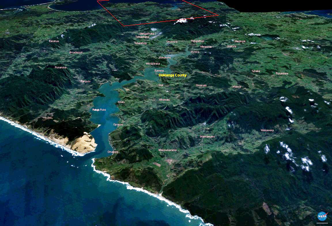
Hokianga
The Hokianga is an area surrounding the Hokianga Harbour, also known as the Hokianga River, a long estuarine drowned valley on the west coast in the north of the North Island of New Zealand.
The original name, still used by local Māori, is Te Kohanga o Te Tai Tokerau ("the nest of the northern people") or Te Puna o Te Ao Marama ("the wellspring in the world of light"). The full name of the harbour is Te Hokianga-nui-a-Kupe — "the place of Kupe's great return".
The Hokianga is in the Far North District, which is in the Northland Region. The area is 120 kilometres (75 mi) northwest of Whangārei City—and 40 kilometres (25 mi) west of Kaikohe—by road. The estuary extends inland for 30 kilometres (19 mi) from the Tasman Sea. It is navigable for small craft for much of its length, although there is a bar across the mouth. In its upper reaches the Rangiora Narrows separate the mouths of the Waihou and Mangamuka Rivers from the lower parts of the harbour.
12,000 years ago, the Hokianga was a river valley flanked by steep bush-clad hills. As the last ice age regressed, the dramatic rise in sea level slowly flooded the valley turning it into a tidal saltwater harbour with abundant sheltered deep water anchorages. This was the harbour that the explorer Kupe left from, and in 1822 it was home to the first European timber entrepreneurs. southern right whales possibly frequented the bay historically, prior to significant depletion of the species caused by commercial and illegal hunting. Today, large whales are rarely seen in the bay, although the harbour is a well-regarded area in which to watch smaller dolphins and killer whales.
Numerous small islands dot the Hokianga, notably Ruapapaka Island, Motukaraka Island, and To Motu Island, the latter being the site of a former pā.
As the Hokianga is a drowned valley, it is the mouth of numerous "tributaries", many of which retain the name river while effectively being bays or inlets. Clockwise from the mouth of the Hokianga, these include:
The area around the harbour is divided in three by the estuary. To the south are the settlements of Waimamaku, Ōmāpere, Opononi, Koutu, Whirinaki, Rawene, Omanaia, Waima, and Taheke; to the north are Broadwood, Pawarenga, Panguru and Mitimiti; and at the top of the harbour upstream from the narrows are Horeke, Kohukohu, and Mangamuka.
According to Te Tai Tokerau tradition, Kupe and Ngāhue, the legendary Polynesian navigators and explorers, settled in Hokianga in approximately 925 AD, after their journey of discovery from Hawaiki aboard their waka (canoe) named Matahorua and Tāwhirirangi. When Kupe left the area, he declared that this would be the place of his return, leaving several things behind—including the bailer of his canoe. Later, Kupe's grandson Nukutawhiti returned from Hawaiki to settle in Hokianga.
Hub AI
Hokianga AI simulator
(@Hokianga_simulator)
Hokianga
The Hokianga is an area surrounding the Hokianga Harbour, also known as the Hokianga River, a long estuarine drowned valley on the west coast in the north of the North Island of New Zealand.
The original name, still used by local Māori, is Te Kohanga o Te Tai Tokerau ("the nest of the northern people") or Te Puna o Te Ao Marama ("the wellspring in the world of light"). The full name of the harbour is Te Hokianga-nui-a-Kupe — "the place of Kupe's great return".
The Hokianga is in the Far North District, which is in the Northland Region. The area is 120 kilometres (75 mi) northwest of Whangārei City—and 40 kilometres (25 mi) west of Kaikohe—by road. The estuary extends inland for 30 kilometres (19 mi) from the Tasman Sea. It is navigable for small craft for much of its length, although there is a bar across the mouth. In its upper reaches the Rangiora Narrows separate the mouths of the Waihou and Mangamuka Rivers from the lower parts of the harbour.
12,000 years ago, the Hokianga was a river valley flanked by steep bush-clad hills. As the last ice age regressed, the dramatic rise in sea level slowly flooded the valley turning it into a tidal saltwater harbour with abundant sheltered deep water anchorages. This was the harbour that the explorer Kupe left from, and in 1822 it was home to the first European timber entrepreneurs. southern right whales possibly frequented the bay historically, prior to significant depletion of the species caused by commercial and illegal hunting. Today, large whales are rarely seen in the bay, although the harbour is a well-regarded area in which to watch smaller dolphins and killer whales.
Numerous small islands dot the Hokianga, notably Ruapapaka Island, Motukaraka Island, and To Motu Island, the latter being the site of a former pā.
As the Hokianga is a drowned valley, it is the mouth of numerous "tributaries", many of which retain the name river while effectively being bays or inlets. Clockwise from the mouth of the Hokianga, these include:
The area around the harbour is divided in three by the estuary. To the south are the settlements of Waimamaku, Ōmāpere, Opononi, Koutu, Whirinaki, Rawene, Omanaia, Waima, and Taheke; to the north are Broadwood, Pawarenga, Panguru and Mitimiti; and at the top of the harbour upstream from the narrows are Horeke, Kohukohu, and Mangamuka.
According to Te Tai Tokerau tradition, Kupe and Ngāhue, the legendary Polynesian navigators and explorers, settled in Hokianga in approximately 925 AD, after their journey of discovery from Hawaiki aboard their waka (canoe) named Matahorua and Tāwhirirangi. When Kupe left the area, he declared that this would be the place of his return, leaving several things behind—including the bailer of his canoe. Later, Kupe's grandson Nukutawhiti returned from Hawaiki to settle in Hokianga.
Recent media