Recent from talks
Hudson Mountains
Knowledge base stats:
Talk channels stats:
Members stats:
Hudson Mountains
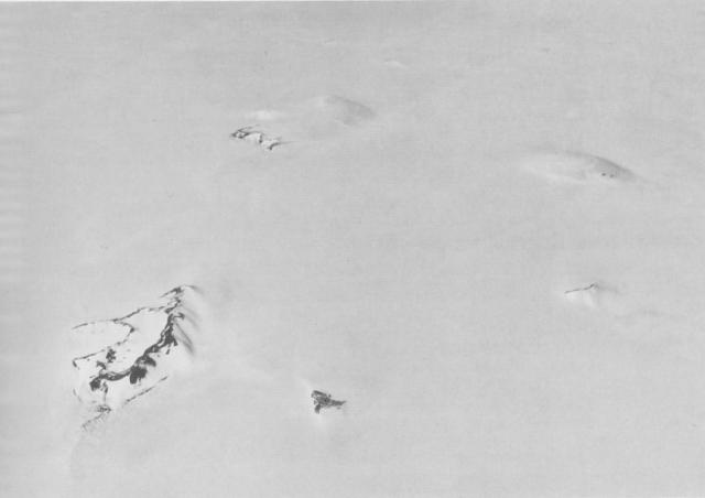
The Hudson Mountains are a mountain range in western Ellsworth Land just east of Pine Island Bay at the Walgreen Coast of the Amundsen Sea. They are of volcanic origin, consisting of low scattered mountains and nunataks that protrude through the West Antarctic Ice Sheet. The Hudson Mountains are bounded on the north by Cosgrove Ice Shelf and on the south by Pine Island Glacier. The mountains were volcanically active during the Miocene and Pliocene, but there is evidence for an eruption about two millennia ago and uncertain indications of activity in the 20th century.
The Hudson Mountains rise in western Ellsworth Land of West Antarctica and were discovered in 1940 by the United States Antarctic Service Expedition. The mountains lie at some distance from the Amundsen Sea's Walgreen Coast, facing Pine Island Bay. The Cosgrove Ice Shelf lies north of the Hudson Mountains. The mountains are remote and visits are rare. In 1991, they were prospected as a potential aircraft landing site.
The mountains are a volcanic field formed by parasitic vents and stratovolcanoes covered in snow and ice, forming a cold desert landscape with an area of about 8,400 square kilometres (3,200 sq mi). About 20 mountains emerge above the Antarctic Ice Sheet in the form of nunataks, with the largest rocky outcrops found at Mount Moses and Maish Nunatak. The stratovolcanoes Mount Manthe, Mount Moses, and Teeters Nunatak constitute the bulk of the volcanic field and are heavily eroded. Better preserved are some parasitic cones and volcanic craters which appear to have formed on these three volcanoes. To their south lies the Pine Island Glacier, while the Larter Glacier traverses the Hudson Mountains between Mount Moses and Mount Manthe and other glaciers from the Hudson Mountains join the Pine Island Glacier. The glaciers are rapidly thinning owing to global warming.
Mount Moses reaches an elevation of 749 metres (2,457 ft) above sea level, Teeters Nunatak 617 metres (2,024 ft), and Mount Manthe 576 metres (1,890 ft). Other named structures are:
The volcanoes are made up by breccia, palagonite tuff, scoriaceous lava flows and tuffs. At Mount Nickles and Mount Moses there are pillow lavas. Lava fragments are dispersed on the slopes of Mount Moses. Volcanic rock sequences that were emplaced under water and under ice are overlaid by volcanic products that were deposed under the atmosphere, there are deposits of volcanic ash and breccia produced by hydromagmatic activity and tuya-like shapes associated with subglacial growth of the volcanoes. At Mount Moses, erosion has exposed dykes. Glaciers have deposited granite boulders and erratic blocks on the Hudson Mountains, and left glacial striations on the pillow lavas of Mount Moses. Physical weathering has yielded soils in some areas. Volcanic glass found in the Pine Island Glacier probably originates in the Hudson Mountains.
Neighbouring Marie Byrd Land was volcanically active during the Cenozoic, forming a number of volcanoes, some of which are buried under ice, while others emerge above the ice sheet. The Hudson Mountains are part of the Thurston Island or Bellingshausen Volcanic Province, and are its largest and best preserved volcanic field. The volcanism at the mountains may have either been caused by a mantle plume under Marie Byrd Land or by the presence of anomalies (slab windows) in the mantle left over by subduction. Seismic tomography has found evidence of low velocity anomalies under the Hudson Mountains, which may reflect the presence of the Marie Byrd Land mantle plume.
The bedrock around the Hudson Mountains lies below sea level. The basement on which the volcanoes formed is not exposed in the Hudson Mountains, but crops out in the neighbouring Jones Mountains. It forms the so-called Thurston Island tectonic block. Below the Hudson Mountains, the crust is about 21–27 kilometres (13–17 mi) thick. A proposal by Lopatin and Polyakov 1974 is that east and north-trending fractures have controlled the position of the volcanoes.
The main volcanic rocks include alkali basalt, basalt, hawaiite and tephrite. They define an alkaline suite, some samples trend towards subalkaline. Ultramafic nodules have been reported from some rocks. The magmas erupted by the volcanoes may have originated in a mantle that had been influenced by subduction, and underwent fractionation of olivine as they ascended.
Hub AI
Hudson Mountains AI simulator
(@Hudson Mountains_simulator)
Hudson Mountains
The Hudson Mountains are a mountain range in western Ellsworth Land just east of Pine Island Bay at the Walgreen Coast of the Amundsen Sea. They are of volcanic origin, consisting of low scattered mountains and nunataks that protrude through the West Antarctic Ice Sheet. The Hudson Mountains are bounded on the north by Cosgrove Ice Shelf and on the south by Pine Island Glacier. The mountains were volcanically active during the Miocene and Pliocene, but there is evidence for an eruption about two millennia ago and uncertain indications of activity in the 20th century.
The Hudson Mountains rise in western Ellsworth Land of West Antarctica and were discovered in 1940 by the United States Antarctic Service Expedition. The mountains lie at some distance from the Amundsen Sea's Walgreen Coast, facing Pine Island Bay. The Cosgrove Ice Shelf lies north of the Hudson Mountains. The mountains are remote and visits are rare. In 1991, they were prospected as a potential aircraft landing site.
The mountains are a volcanic field formed by parasitic vents and stratovolcanoes covered in snow and ice, forming a cold desert landscape with an area of about 8,400 square kilometres (3,200 sq mi). About 20 mountains emerge above the Antarctic Ice Sheet in the form of nunataks, with the largest rocky outcrops found at Mount Moses and Maish Nunatak. The stratovolcanoes Mount Manthe, Mount Moses, and Teeters Nunatak constitute the bulk of the volcanic field and are heavily eroded. Better preserved are some parasitic cones and volcanic craters which appear to have formed on these three volcanoes. To their south lies the Pine Island Glacier, while the Larter Glacier traverses the Hudson Mountains between Mount Moses and Mount Manthe and other glaciers from the Hudson Mountains join the Pine Island Glacier. The glaciers are rapidly thinning owing to global warming.
Mount Moses reaches an elevation of 749 metres (2,457 ft) above sea level, Teeters Nunatak 617 metres (2,024 ft), and Mount Manthe 576 metres (1,890 ft). Other named structures are:
The volcanoes are made up by breccia, palagonite tuff, scoriaceous lava flows and tuffs. At Mount Nickles and Mount Moses there are pillow lavas. Lava fragments are dispersed on the slopes of Mount Moses. Volcanic rock sequences that were emplaced under water and under ice are overlaid by volcanic products that were deposed under the atmosphere, there are deposits of volcanic ash and breccia produced by hydromagmatic activity and tuya-like shapes associated with subglacial growth of the volcanoes. At Mount Moses, erosion has exposed dykes. Glaciers have deposited granite boulders and erratic blocks on the Hudson Mountains, and left glacial striations on the pillow lavas of Mount Moses. Physical weathering has yielded soils in some areas. Volcanic glass found in the Pine Island Glacier probably originates in the Hudson Mountains.
Neighbouring Marie Byrd Land was volcanically active during the Cenozoic, forming a number of volcanoes, some of which are buried under ice, while others emerge above the ice sheet. The Hudson Mountains are part of the Thurston Island or Bellingshausen Volcanic Province, and are its largest and best preserved volcanic field. The volcanism at the mountains may have either been caused by a mantle plume under Marie Byrd Land or by the presence of anomalies (slab windows) in the mantle left over by subduction. Seismic tomography has found evidence of low velocity anomalies under the Hudson Mountains, which may reflect the presence of the Marie Byrd Land mantle plume.
The bedrock around the Hudson Mountains lies below sea level. The basement on which the volcanoes formed is not exposed in the Hudson Mountains, but crops out in the neighbouring Jones Mountains. It forms the so-called Thurston Island tectonic block. Below the Hudson Mountains, the crust is about 21–27 kilometres (13–17 mi) thick. A proposal by Lopatin and Polyakov 1974 is that east and north-trending fractures have controlled the position of the volcanoes.
The main volcanic rocks include alkali basalt, basalt, hawaiite and tephrite. They define an alkaline suite, some samples trend towards subalkaline. Ultramafic nodules have been reported from some rocks. The magmas erupted by the volcanoes may have originated in a mantle that had been influenced by subduction, and underwent fractionation of olivine as they ascended.
Recent media