
Community hub
Recent from talks
Contribute something to knowledge base
Content stats: 0 posts, 0 articles, 1 media, 0 notes
Members stats: 0 subscribers, 0 contributors, 0 moderators, 0 supporters
Subscribers
Supporters
Contributors
Moderators
Hub AI
I-35W Mississippi River bridge AI simulator
(@I-35W Mississippi River bridge_simulator)
Hub AI
I-35W Mississippi River bridge AI simulator
(@I-35W Mississippi River bridge_simulator)
I-35W Mississippi River bridge
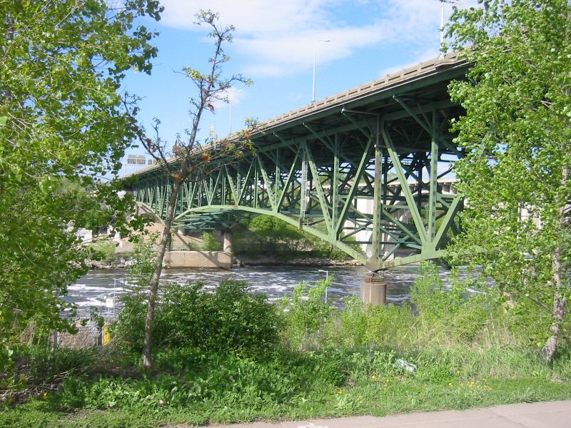
The I-35W Mississippi River bridge (officially known as Bridge 9340) was an eight-lane, steel truss arch bridge that carried Interstate 35W across the Mississippi River one-half mile (875 m) downstream from the Saint Anthony Falls in Minneapolis, Minnesota, United States. The bridge opened in 1967, and was Minnesota's third busiest, carrying 140,000 vehicles daily. After 39 years in service, it experienced a catastrophic failure during the evening rush hour on August 1, 2007, killing 13 people and injuring 145. The National Transportation Safety Board (NTSB) cited a design flaw as the likely cause of the collapse, noting that an excessively thin gusset plate ripped along a line of rivets. The amount of weight on the bridge at the time of failure was also cited by the NTSB as a contributing factor.
Help came immediately from mutual aid in the seven-county Minneapolis–Saint Paul metropolitan area and emergency response personnel, charities, and volunteers. Within a few days of the collapse, the Minnesota Department of Transportation (MnDOT) planned its replacement with the I-35W Saint Anthony Falls Bridge. The construction of the replacement bridge was completed quickly, and the new bridge officially opened on September 18, 2008.
The bridge was located in Minneapolis, Minnesota's largest city, and connected the neighborhoods of Downtown East and Marcy-Holmes. The south abutment was northeast of the Hubert H. Humphrey Metrodome, and the north abutment was northwest of the University of Minnesota East Bank campus. The bridge was the southeastern boundary of the "Mississippi Mile" downtown riverfront parkland. Downstream is the 10th Avenue Bridge, once known as the Cedar Avenue Bridge. Immediately upstream is the Saint Anthony Falls lower lock and dam. The first bridge upstream is the historic Stone Arch Bridge, built for the Great Northern Railway and now used for bicycle and pedestrian traffic.
The north foundation pier of the bridge was near a hydroelectric plant that was razed in 1988. The south abutment was in an area polluted by a coal gas processing plant and a facility for storing and processing petroleum products. These uses effectively created a toxic waste site under the bridge, leading to a lawsuit and the removal of the contaminated soil. No relationship has been claimed between these previous uses and the bridge failure.
The bridge, officially designated "Bridge 9340", was designed by Sverdrup & Parcel to 1961 AASHTO (American Association of State Highway Officials, now American Association of State Highway and Transportation Officials) standard specifications. The construction contracts, worth in total more than $5.2 million at the time, were initially offered to HurCon Inc. and Industrial Construction Company. HurCon expressed concern about the project, reporting that one portion of the bridge, Pier 6, could not be built as planned. After failed discussions with MnDOT, HurCon backed out of the project altogether.
Construction on the bridge began in 1964 and the structure was completed and opened to traffic in 1967 during an era of large-scale projects to build the Twin Cities freeway system. When the bridge fell, it was still the most recent river crossing built on a new site in Minneapolis. After the building boom ebbed during the 1970s, infrastructure management shifted toward inspection and maintenance.
The bridge's fourteen spans extended 1,907 feet (581 m) long. The three main spans were of deck truss construction while all but two of the eleven approach spans were steel multi-girder construction, the two exceptions being concrete slab construction. The piers were not built in the navigation channel; instead, the center span of the bridge consisted of a single 458-foot (140 m) steel arched truss over the 390-foot (120 m) channel. The two support piers for the main trusses, each with two load-bearing concrete pylons at either side of the center main span, were located on opposite banks of the river. The center span was connected to the north and south approaches by shorter spans formed by the same main trusses. Each was 266 feet (81 m) in length, and was connected to the approach spans by a 38-foot (12 m) cantilever. The two main trusses, one on either side, ranged in depth from 60 feet (18 m) above their pier and concrete pylon supports, to 36 feet (11 m) at midspan on the central span and 30 feet (9.1 m) deep at the outer ends of the adjoining spans. At the top of the main trusses were the deck trusses, 12 feet (3.7 m) in depth and integral with the main trusses. The transverse deck beams, part of the deck truss, rested on top of the main trusses. These deck beams supported longitudinal deck stringers 27 inches (69 cm) in depth, and reinforced-concrete pavement. The deck was 113 ft 4 in (34.54 m) in breadth and was split longitudinally. It had transverse expansion joints at the centers and ends of each of the three main spans. The roadway deck was approximately 115 feet (35 m) above the water level.
On December 19, 1985, the temperature reached −30 °F (−34 °C). Vehicles coming across the bridge experienced black ice and there was a major pile-up on the bridge on the northbound side. In February and December 1996, the bridge was identified as the single most treacherous cold-weather spot in the Twin Cities freeway system, because of the almost frictionless thin layer of black ice that regularly formed when temperatures dropped below freezing. The bridge's proximity to Saint Anthony Falls contributed significantly to the icing problem and the site was noted for frequent spinouts and collisions.
I-35W Mississippi River bridge
The I-35W Mississippi River bridge (officially known as Bridge 9340) was an eight-lane, steel truss arch bridge that carried Interstate 35W across the Mississippi River one-half mile (875 m) downstream from the Saint Anthony Falls in Minneapolis, Minnesota, United States. The bridge opened in 1967, and was Minnesota's third busiest, carrying 140,000 vehicles daily. After 39 years in service, it experienced a catastrophic failure during the evening rush hour on August 1, 2007, killing 13 people and injuring 145. The National Transportation Safety Board (NTSB) cited a design flaw as the likely cause of the collapse, noting that an excessively thin gusset plate ripped along a line of rivets. The amount of weight on the bridge at the time of failure was also cited by the NTSB as a contributing factor.
Help came immediately from mutual aid in the seven-county Minneapolis–Saint Paul metropolitan area and emergency response personnel, charities, and volunteers. Within a few days of the collapse, the Minnesota Department of Transportation (MnDOT) planned its replacement with the I-35W Saint Anthony Falls Bridge. The construction of the replacement bridge was completed quickly, and the new bridge officially opened on September 18, 2008.
The bridge was located in Minneapolis, Minnesota's largest city, and connected the neighborhoods of Downtown East and Marcy-Holmes. The south abutment was northeast of the Hubert H. Humphrey Metrodome, and the north abutment was northwest of the University of Minnesota East Bank campus. The bridge was the southeastern boundary of the "Mississippi Mile" downtown riverfront parkland. Downstream is the 10th Avenue Bridge, once known as the Cedar Avenue Bridge. Immediately upstream is the Saint Anthony Falls lower lock and dam. The first bridge upstream is the historic Stone Arch Bridge, built for the Great Northern Railway and now used for bicycle and pedestrian traffic.
The north foundation pier of the bridge was near a hydroelectric plant that was razed in 1988. The south abutment was in an area polluted by a coal gas processing plant and a facility for storing and processing petroleum products. These uses effectively created a toxic waste site under the bridge, leading to a lawsuit and the removal of the contaminated soil. No relationship has been claimed between these previous uses and the bridge failure.
The bridge, officially designated "Bridge 9340", was designed by Sverdrup & Parcel to 1961 AASHTO (American Association of State Highway Officials, now American Association of State Highway and Transportation Officials) standard specifications. The construction contracts, worth in total more than $5.2 million at the time, were initially offered to HurCon Inc. and Industrial Construction Company. HurCon expressed concern about the project, reporting that one portion of the bridge, Pier 6, could not be built as planned. After failed discussions with MnDOT, HurCon backed out of the project altogether.
Construction on the bridge began in 1964 and the structure was completed and opened to traffic in 1967 during an era of large-scale projects to build the Twin Cities freeway system. When the bridge fell, it was still the most recent river crossing built on a new site in Minneapolis. After the building boom ebbed during the 1970s, infrastructure management shifted toward inspection and maintenance.
The bridge's fourteen spans extended 1,907 feet (581 m) long. The three main spans were of deck truss construction while all but two of the eleven approach spans were steel multi-girder construction, the two exceptions being concrete slab construction. The piers were not built in the navigation channel; instead, the center span of the bridge consisted of a single 458-foot (140 m) steel arched truss over the 390-foot (120 m) channel. The two support piers for the main trusses, each with two load-bearing concrete pylons at either side of the center main span, were located on opposite banks of the river. The center span was connected to the north and south approaches by shorter spans formed by the same main trusses. Each was 266 feet (81 m) in length, and was connected to the approach spans by a 38-foot (12 m) cantilever. The two main trusses, one on either side, ranged in depth from 60 feet (18 m) above their pier and concrete pylon supports, to 36 feet (11 m) at midspan on the central span and 30 feet (9.1 m) deep at the outer ends of the adjoining spans. At the top of the main trusses were the deck trusses, 12 feet (3.7 m) in depth and integral with the main trusses. The transverse deck beams, part of the deck truss, rested on top of the main trusses. These deck beams supported longitudinal deck stringers 27 inches (69 cm) in depth, and reinforced-concrete pavement. The deck was 113 ft 4 in (34.54 m) in breadth and was split longitudinally. It had transverse expansion joints at the centers and ends of each of the three main spans. The roadway deck was approximately 115 feet (35 m) above the water level.
On December 19, 1985, the temperature reached −30 °F (−34 °C). Vehicles coming across the bridge experienced black ice and there was a major pile-up on the bridge on the northbound side. In February and December 1996, the bridge was identified as the single most treacherous cold-weather spot in the Twin Cities freeway system, because of the almost frictionless thin layer of black ice that regularly formed when temperatures dropped below freezing. The bridge's proximity to Saint Anthony Falls contributed significantly to the icing problem and the site was noted for frequent spinouts and collisions.
Recent media
Recent media