Recent from talks
Interstate Park
Knowledge base stats:
Talk channels stats:
Members stats:
Interstate Park
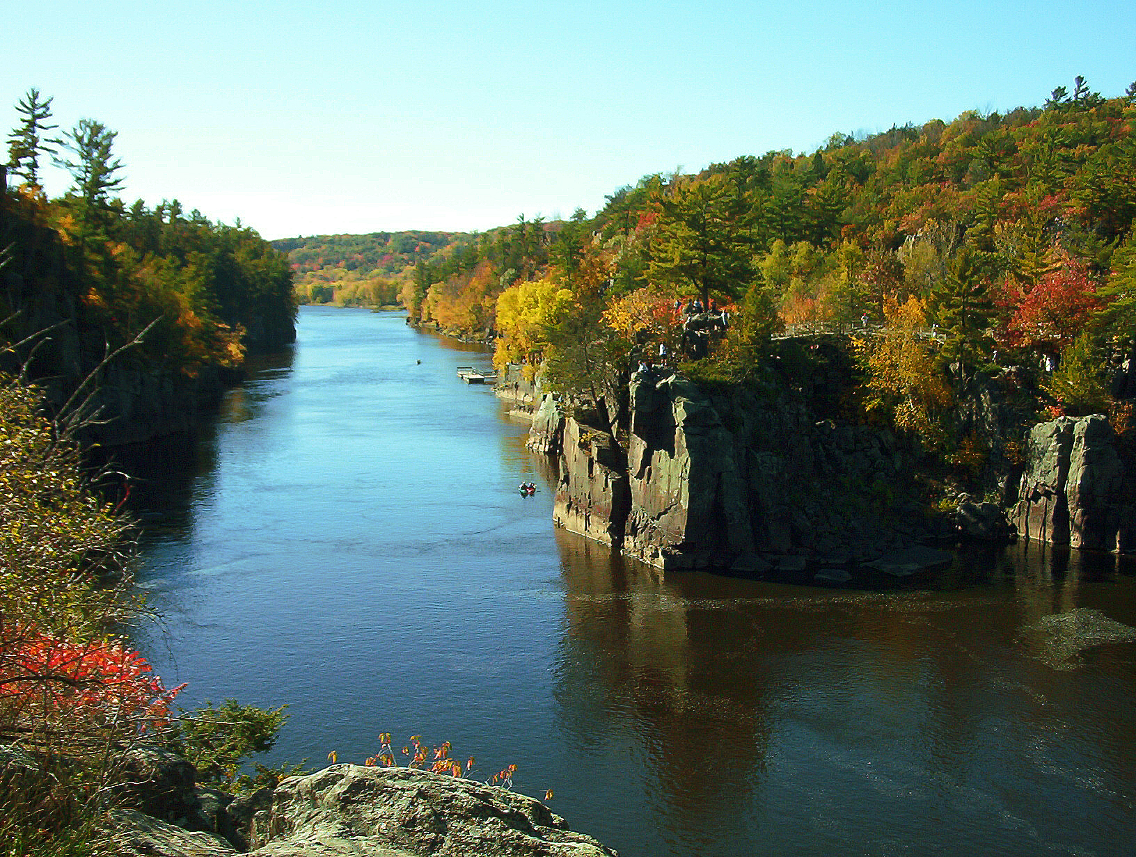
Interstate Park comprises two adjacent state parks on the Minnesota–Wisconsin border, both named Interstate State Park. They straddle the Dalles of the St. Croix River, a deep basalt gorge with glacial potholes and other rock formations. The Wisconsin park is 1,330 acres (538 ha) and the Minnesota park is 298 acres (121 ha). The towns of Taylors Falls, Minnesota and St. Croix Falls, Wisconsin are adjacent to the park. Interstate Park is within the Saint Croix National Scenic Riverway and the Ice Age National Scientific Reserve. The western terminus of the Ice Age National Scenic Trail is on the Wisconsin side. On the Minnesota side, two areas contain National Park Service rustic style buildings and structures that are listed on the National Register of Historic Places.
Rocks or sediment from three short intervals of geologic time, each from three different geological eras, Precambrian, Paleozoic, and Cenozoic, are exposed at the surface within Interstate Park. The oldest strata are of the Keweenawan Supergroup, which is a 2.5 miles (4.0 km) thick sequence of volcanic and sedimentary strata that fill a segment of the Midcontinent Rift System. During the formation of the Midcontinent Rift System, these strata accumulated about 1.1 billion years ago as a series of basaltic lava flows and alluvial fans filled an ancient rift valley to depth of over 2.5 miles (4.0 km). At least ten separate lava flows are exposed within the region of Interstate Park. Since their accumulation, these strata within Interstate Park area have undergone very low to low-grade metamorphism.
In the Cambrian period of the Paleozoic Era, between 530 and 470 million years ago, the region was covered by a shallow sea which deposited sandstone and siltstone atop the basalt. This epoch of the Cambrian, the Furongian, was originally called the Croixian in North America because the layers exposed in this area were its type locality.
The presence of older glacial deposits south of the Interstate Park demonstrates that the Laurentide Ice Sheet repeatedly glaciated it and surrounding areas over the Pleistocene Epoch. Within Wisconsin, these older glacial deposits consist of remnants of, highly weathered dark-gray loam till and lake sediment with reversed magnetic polarity and a deeply weathered, pre-Sangamonian Stage, reddish-brown, sandy loam till with normal magnetic polarity. Both the landforms and deposits related to these earlier glaciations have been either eroded or buried by the latest advance of the Laurentide Ice Sheet over this area of the Last Glacial Maximum.
The region of Interstate Park was deglaciated sometime between about 19,000 and 14,000 BP calibrated (16,000 and 12,000 14C uncalibrated). During this time, the Superior Lobe had retreated from the St. Croix Moraine northeastward to the Thompson Moraine. Between 14,000 and 11,500 BP calibrated (12,000 and 10,000 14C uncalibrated), an extensive set of ice marginal channels drained meltwater from the Thompson Moraine by way of the Brule channel into the newly formed St. Croix River.
The glacial landforms and sediments of Interstate Park were largely created during the retreat of the Superior Lobe from this region and periodic outburst flood events from proglacial lakes, e.g. Lake Duluth, since the Last Glacial Maximum. First, the retreat of the Superior lobe into the Lake Superior basin created proglacial lakes. Initially, these lakes consisted of small, proglacial lakes. Later, these lakes coalesced to form a large proglacial lake called glacial Lake Duluth, which was confined to the western Superior basin. The most prominent of multiple lake levels of glacial Lake Duluth is known as the Duluth level. There also was an older epi-Duluth level that lay above the Duluth level. The epi-Duluth level and a smaller precursor proglacial lake, named Lake Nemadji, drained through the higher Moose Lake (Portage) outlet into the Kettle River and into the St. Croix River. As the Lake Superior Lobe retreated, the Brule outlet opened and the higher Moose Lake was abandoned as a lower Duluth level was quickly established by massive and sudden outflow through the lower Brule outlet and down St. Croix River. The Brule outlet was abandoned when Lake Superior Lobe retreated from the Keweenaw Peninsula and opened lower eastward draining outlets. This caused the Duluth level to drop abruptly to post-Duluth levels and water to cease flowing into lower Brule outlet and down the St. Croix River.
It was during the regional retreat of the Lake Superior Lobe and glacial meltwater flow from deglaciation and glacial Lake Nemadji and Lake Duluth caused the entrenchment of the St. Croix River and the formation of the deep gorge of the St. Croix River of the St. Croix River valley and its famous potholes occurred. In and surrounding Polk County, Minnesota, geomorphic and stratigraphic relationships evidence exists for at least two drainage events.
A strath terrace, known as the Chengwatana surface provides evidence for the occurrence of the first drainage event. The Chengwatana surface is a scoured surface marked by distinct lemniscate landforms; bar-shaped lndforms composed of sand; and a lag layer of cobbles and boulders. This lag layer overlies an unconformity eroded into older glacial till, lake sediment, or bedrock. This surface extends from the lower reaches of the Kettle River valley as far south as Sunrise, Minnesota. The Chengwatana surface likely was cut by water flowing down the Kettle River from the Moose Lake outlet of glacial Lake Nemadji and the Epi-Duluth level of glacial Lake Duluth. The association of the Chengwatana surface with glacial Lake Nemadji and the Epi-Duluth level of glacial Lake Duluth would make it most likely range in age from before 12,100 to about 11,700 BP calibrated.
Hub AI
Interstate Park AI simulator
(@Interstate Park_simulator)
Interstate Park
Interstate Park comprises two adjacent state parks on the Minnesota–Wisconsin border, both named Interstate State Park. They straddle the Dalles of the St. Croix River, a deep basalt gorge with glacial potholes and other rock formations. The Wisconsin park is 1,330 acres (538 ha) and the Minnesota park is 298 acres (121 ha). The towns of Taylors Falls, Minnesota and St. Croix Falls, Wisconsin are adjacent to the park. Interstate Park is within the Saint Croix National Scenic Riverway and the Ice Age National Scientific Reserve. The western terminus of the Ice Age National Scenic Trail is on the Wisconsin side. On the Minnesota side, two areas contain National Park Service rustic style buildings and structures that are listed on the National Register of Historic Places.
Rocks or sediment from three short intervals of geologic time, each from three different geological eras, Precambrian, Paleozoic, and Cenozoic, are exposed at the surface within Interstate Park. The oldest strata are of the Keweenawan Supergroup, which is a 2.5 miles (4.0 km) thick sequence of volcanic and sedimentary strata that fill a segment of the Midcontinent Rift System. During the formation of the Midcontinent Rift System, these strata accumulated about 1.1 billion years ago as a series of basaltic lava flows and alluvial fans filled an ancient rift valley to depth of over 2.5 miles (4.0 km). At least ten separate lava flows are exposed within the region of Interstate Park. Since their accumulation, these strata within Interstate Park area have undergone very low to low-grade metamorphism.
In the Cambrian period of the Paleozoic Era, between 530 and 470 million years ago, the region was covered by a shallow sea which deposited sandstone and siltstone atop the basalt. This epoch of the Cambrian, the Furongian, was originally called the Croixian in North America because the layers exposed in this area were its type locality.
The presence of older glacial deposits south of the Interstate Park demonstrates that the Laurentide Ice Sheet repeatedly glaciated it and surrounding areas over the Pleistocene Epoch. Within Wisconsin, these older glacial deposits consist of remnants of, highly weathered dark-gray loam till and lake sediment with reversed magnetic polarity and a deeply weathered, pre-Sangamonian Stage, reddish-brown, sandy loam till with normal magnetic polarity. Both the landforms and deposits related to these earlier glaciations have been either eroded or buried by the latest advance of the Laurentide Ice Sheet over this area of the Last Glacial Maximum.
The region of Interstate Park was deglaciated sometime between about 19,000 and 14,000 BP calibrated (16,000 and 12,000 14C uncalibrated). During this time, the Superior Lobe had retreated from the St. Croix Moraine northeastward to the Thompson Moraine. Between 14,000 and 11,500 BP calibrated (12,000 and 10,000 14C uncalibrated), an extensive set of ice marginal channels drained meltwater from the Thompson Moraine by way of the Brule channel into the newly formed St. Croix River.
The glacial landforms and sediments of Interstate Park were largely created during the retreat of the Superior Lobe from this region and periodic outburst flood events from proglacial lakes, e.g. Lake Duluth, since the Last Glacial Maximum. First, the retreat of the Superior lobe into the Lake Superior basin created proglacial lakes. Initially, these lakes consisted of small, proglacial lakes. Later, these lakes coalesced to form a large proglacial lake called glacial Lake Duluth, which was confined to the western Superior basin. The most prominent of multiple lake levels of glacial Lake Duluth is known as the Duluth level. There also was an older epi-Duluth level that lay above the Duluth level. The epi-Duluth level and a smaller precursor proglacial lake, named Lake Nemadji, drained through the higher Moose Lake (Portage) outlet into the Kettle River and into the St. Croix River. As the Lake Superior Lobe retreated, the Brule outlet opened and the higher Moose Lake was abandoned as a lower Duluth level was quickly established by massive and sudden outflow through the lower Brule outlet and down St. Croix River. The Brule outlet was abandoned when Lake Superior Lobe retreated from the Keweenaw Peninsula and opened lower eastward draining outlets. This caused the Duluth level to drop abruptly to post-Duluth levels and water to cease flowing into lower Brule outlet and down the St. Croix River.
It was during the regional retreat of the Lake Superior Lobe and glacial meltwater flow from deglaciation and glacial Lake Nemadji and Lake Duluth caused the entrenchment of the St. Croix River and the formation of the deep gorge of the St. Croix River of the St. Croix River valley and its famous potholes occurred. In and surrounding Polk County, Minnesota, geomorphic and stratigraphic relationships evidence exists for at least two drainage events.
A strath terrace, known as the Chengwatana surface provides evidence for the occurrence of the first drainage event. The Chengwatana surface is a scoured surface marked by distinct lemniscate landforms; bar-shaped lndforms composed of sand; and a lag layer of cobbles and boulders. This lag layer overlies an unconformity eroded into older glacial till, lake sediment, or bedrock. This surface extends from the lower reaches of the Kettle River valley as far south as Sunrise, Minnesota. The Chengwatana surface likely was cut by water flowing down the Kettle River from the Moose Lake outlet of glacial Lake Nemadji and the Epi-Duluth level of glacial Lake Duluth. The association of the Chengwatana surface with glacial Lake Nemadji and the Epi-Duluth level of glacial Lake Duluth would make it most likely range in age from before 12,100 to about 11,700 BP calibrated.
Recent media