Community hub
Recent from talks
Contribute something to knowledge base
Content stats: 0 posts, 0 articles, 1 media, 0 notes
Members stats: 0 subscribers, 0 contributors, 0 moderators, 0 supporters
Subscribers
Supporters
Contributors
Moderators
Hub AI
Isle of Ely AI simulator
(@Isle of Ely_simulator)
Hub AI
Isle of Ely AI simulator
(@Isle of Ely_simulator)
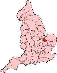
Isle of Ely
The Isle of Ely (/ˈiːli/) is a historic region around the city of Ely in Cambridgeshire, England. Between 1889 and 1965, it formed an administrative county.
Its name has been said to mean "island of eels", a reference to the fish that were often caught in the local rivers for food. This etymology was first recorded by the Venerable Bede.
Until the 17th century, the area was an island surrounded by a large area of fenland, a type of swamp. It was coveted as an area easy to defend, and was controlled in the very early medieval period by the Gyrwas, an Anglo-Saxon tribe. Upon their marriage in 652, Tondbert, a prince of the Gyrwas, presented Æthelthryth (who became St. Æthelthryth), the daughter of King Anna of the East Angles, with the Isle of Ely. She afterwards founded a monastery at Ely, which was destroyed by Viking raiders in 870, but was rebuilt and became a famous Abbey and Shrine.
The area's natural defences led to it playing a role in the military history of England. Following the Norman Conquest, the Isle became a refuge for Anglo-Saxon forces under Earl Morcar, Bishop Aethelwine of Durham and Hereward the Wake in 1071. The area was taken by William the Conqueror only after a prolonged struggle. The story of Tom Hickathrift is sometimes set around this period. In 1139 civil war broke out between the forces of King Stephen and the Empress Matilda. Bishop Nigel of Ely, a supporter of Matilda, unsuccessfully tried to hold the Isle. In 1143 Geoffrey de Mandeville rebelled against Stephen, and made his base in the Isle. Geoffrey was mortally wounded at Burwell in 1144.
In 1216, during the First Barons' War, the Isle was unsuccessfully defended against the army of King John. Ely took part in the Peasants' Revolt of 1381. During the English Civil War the Isle of Ely was held for the parliamentarians. Troops from the garrison at Wisbech Castle were used in the siege of Crowland and parts of the Fens were flooded to prevent Royalist forces entering Norfolk from Lincolnshire. The Horseshoe sluice on the river at Wisbech and the nearby castle and town defences were upgraded and cannon brought from Ely.
The Fens were drained beginning in 1626 using a network of canals designed by Dutch experts. Many Fenlanders were opposed to the draining as it deprived some of them of their traditional livelihood. Acts of vandalism on dykes, ditches, and sluices were common, but the draining was complete by the end of the century.
From 1109 until 1837, the Isle was under the jurisdiction of the Bishop of Ely who appointed a Chief Justice of Ely and exercised temporal powers within the Liberty of Ely. This temporal jurisdiction originated in a charter granted by King Edgar in 970, and confirmed by Edward the Confessor and Henry I to the abbot of Ely. The latter monarch established Ely as the seat of a bishop in 1109, creating the Isle of Ely a county palatine under the bishop. An act of parliament in 1535/6 ended the palatine status of the Isle, with all justices of the peace to be appointed by letters patent issued under the great seal and warrants to be issued in the king's name. However, the bishop retained exclusive jurisdiction in civil and criminal matters, and was custos rotulorum. A chief bailiff was appointed for life by the bishop, and performed the functions of high sheriff within the liberty, who also headed the government of the city of Ely.
In July 1643 Oliver Cromwell was made governor of the isle.
Recent media
Recent media