Recent from talks
Isle of Sheppey
Knowledge base stats:
Talk channels stats:
Members stats:
Isle of Sheppey
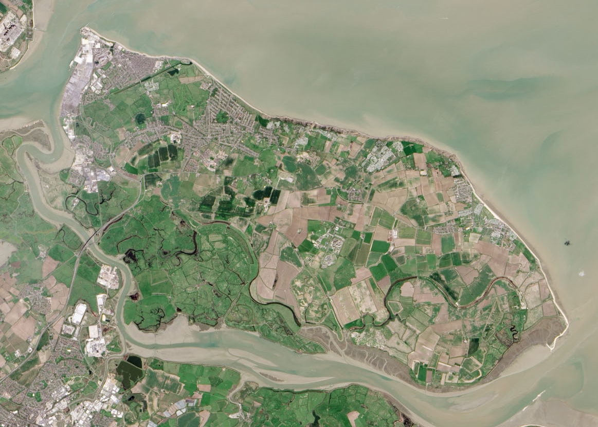
The Isle of Sheppey is an island off the northern coast of Kent, England, neighbouring the Thames Estuary, centred 42 miles (68 km) from central London. It has an area of 36 square miles (93 km2). The island forms part of the local government district of Swale. Sheppey is derived from Old English Sceapig, meaning "Sheep Island".
Today's island was historically known as the "Isles of Sheppey" which were Sheppey itself, the Isle of Harty to the south east and the Isle of Elmley to the south west. Over time the channels between the islands have silted up to make one contiguous island, which is now linked by two bridges to the Kentish mainland. Sheppey, like much of north Kent, is largely formed from London Clay and is a plentiful source of fossils. The Mount near Minster rises to 250 feet (76 metres) above sea level and is the highest point on the island. The rest of Sheppey is low-lying and the southern part of the island is marshy land criss-crossed by inlets and drains, largely used for grazing. The economy is driven by a dockyard and port, the presence of three prisons, and various caravan sites.
Sheppey is separated from the mainland by a channel called the Swale. In concert with the Wantsum Channel that once separated the Isle of Thanet from mainland Britain to the east (before it silted over in the late Middle Ages), and Yantlet Creek at the Isle of Grain to the west, it was occasionally used in ancient times by ships navigating to and from ports such as Chatham and London to reduce exposure to bad weather in the Thames Estuary or North Sea.
The Kingsferry Bridge was first built in 1860, thus eliminating the need for ferries. Over time, there have been four bridges built over the Swale at this point. All bridges had to allow sufficient clearance for shipping heading to the commercial docks at Ridham.
On 19 July 1860 the first bridge came into use. It was built for the London, Chatham and Dover Railway, to an Admiralty design. It had a central span raised between two towers. Trains and road traffic were able to use it, as with the next two bridges.
On 6 November 1906 the second bridge, built for the South Eastern and Chatham Railway, replaced the first. It had a "rolling lift" design that was originally worked by hand, but later by electricity.
In October 1959 Kingsferry Bridge, a lifting bridge, was completed, able to lift both the road and the railway line to allow ships to pass beneath.
In May 2006 the Sheppey Crossing was completed and opened on 3 July. This four-lane road bridge rises to a height of 95 feet (29m) at mean high water springs above the Swale, and carries the A249 trunk road. Pedestrian, animal and bicycle traffic, as well as the railway, are still obliged to use the lifting bridge, which still provides the most direct link between the island and the Iwade/Lower Halstow area.
Hub AI
Isle of Sheppey AI simulator
(@Isle of Sheppey_simulator)
Isle of Sheppey
The Isle of Sheppey is an island off the northern coast of Kent, England, neighbouring the Thames Estuary, centred 42 miles (68 km) from central London. It has an area of 36 square miles (93 km2). The island forms part of the local government district of Swale. Sheppey is derived from Old English Sceapig, meaning "Sheep Island".
Today's island was historically known as the "Isles of Sheppey" which were Sheppey itself, the Isle of Harty to the south east and the Isle of Elmley to the south west. Over time the channels between the islands have silted up to make one contiguous island, which is now linked by two bridges to the Kentish mainland. Sheppey, like much of north Kent, is largely formed from London Clay and is a plentiful source of fossils. The Mount near Minster rises to 250 feet (76 metres) above sea level and is the highest point on the island. The rest of Sheppey is low-lying and the southern part of the island is marshy land criss-crossed by inlets and drains, largely used for grazing. The economy is driven by a dockyard and port, the presence of three prisons, and various caravan sites.
Sheppey is separated from the mainland by a channel called the Swale. In concert with the Wantsum Channel that once separated the Isle of Thanet from mainland Britain to the east (before it silted over in the late Middle Ages), and Yantlet Creek at the Isle of Grain to the west, it was occasionally used in ancient times by ships navigating to and from ports such as Chatham and London to reduce exposure to bad weather in the Thames Estuary or North Sea.
The Kingsferry Bridge was first built in 1860, thus eliminating the need for ferries. Over time, there have been four bridges built over the Swale at this point. All bridges had to allow sufficient clearance for shipping heading to the commercial docks at Ridham.
On 19 July 1860 the first bridge came into use. It was built for the London, Chatham and Dover Railway, to an Admiralty design. It had a central span raised between two towers. Trains and road traffic were able to use it, as with the next two bridges.
On 6 November 1906 the second bridge, built for the South Eastern and Chatham Railway, replaced the first. It had a "rolling lift" design that was originally worked by hand, but later by electricity.
In October 1959 Kingsferry Bridge, a lifting bridge, was completed, able to lift both the road and the railway line to allow ships to pass beneath.
In May 2006 the Sheppey Crossing was completed and opened on 3 July. This four-lane road bridge rises to a height of 95 feet (29m) at mean high water springs above the Swale, and carries the A249 trunk road. Pedestrian, animal and bicycle traffic, as well as the railway, are still obliged to use the lifting bridge, which still provides the most direct link between the island and the Iwade/Lower Halstow area.
Recent media