
Recent from talks
Islip (hamlet), New York
Knowledge base stats:
Talk channels stats:
Members stats:
Islip (hamlet), New York
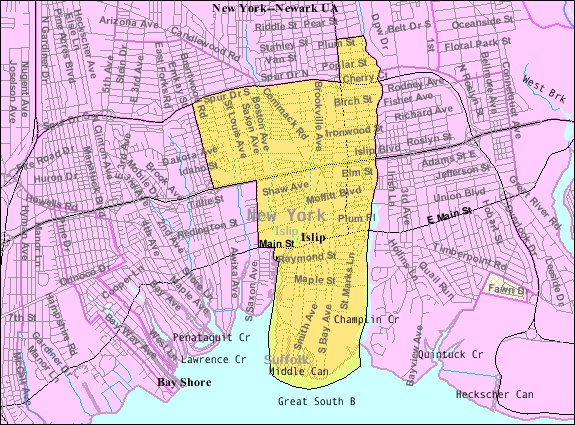
Islip (/ˈaɪslɪp/ EYE-slip) is a hamlet and census-designated place (CDP) that lies within the town of the same name in Suffolk County, New York. Located on the south shore of Long Island, the CDP had a population of 18,869 at the time of the 2010 census, a decline of 8% from the 2000 census.
William Nicoll, a son of New York City Mayor Matthias Nicoll, became a patentee in the 1680s of the east end of what is now the Town of Islip. He accumulated over 100 square miles (260 km2) and named his estate Islip, after the Nicolls' ancestral home in East Northamptonshire, England. His domain included what are now the hamlets of Islip, East Islip, Bayport, Sayville, West Sayville, Oakdale, Great River, Islip Terrace, Central Islip, Hauppauge, Holbrook, Bohemia, Brentwood, Holtsville, and a portion of Ronkonkoma. This land was purchased from Winnequaheagh, Sachem of Connetquot in 1683. The annual fee paid to Governor Thomas Dongan of New York was five bushels of good winter wheat or 25 shillings.
The name "Islip" was chosen by local residents for their local post office when it opened in 1802. Islip was originally a farming community, gradually transforming into a posh enclave for wealthy families in the 19th and 20th centuries. Many of the Colonial Revival, Greek Revival, Romanesque Revival, Federal, Moorish and Victorian mansions that once lined the streets of Islip have been razed, though some remain, adjacent to many newer, large homes. Islip has a wealth of extant Queen Anne Revival homes. Located along the picturesque Great South Bay, Islip has a long history associated with fishing, clamming (the world-famous Doxsee Clam Company started in Islip), swimming and boating. Islip Hamlet has its own public bathing beach, under the jurisdiction of the town. Boating and yachting are as popular today as they were years ago, if not more so, with the development of the communities on the adjacent barrier beach of Fire Island.
According to the United States Census Bureau, the CDP has a total area of 4.9 square miles (12.7 km2), of which 4.8 square miles (12.4 km2) is land and 0.12 square miles (0.3 km2) – or 2.43% – is water.
Islip is situated on Long Island's South Shore, on the north side of Great South Bay, across from Fire Island.
The Seatuck National Wildlife Refuge is located at the hamlet's southeastern corner.
As of the census of 2000, there were 20,575 people, 6,868 households and 5,302 families residing in Islip CDP. The population density was 3,808.8 inhabitants per square mile (1,470.6/km2). There were 7,026 housing units, at an average density of 1,300.6 per square mile (502.2/km2). The racial makeup of Islip was 87.67% White, 10.67% Hispanic, 4.90% Black or African-American, 0.10% Native American, 2.07% Asian, 0.03% Pacific Islander, 3.02% from other races, and 2.22% from two or more races.
There were 6,868 households, out of which 38.4% had children under the age of 18 living with them, 61.4% were married couples living together, 12.0% had a female householder with no husband present, and 22.8% were non-families. 18.4% of all households were made up of individuals, and 7.7% had someone living alone who was 65 years of age or older. The average household size was 2.97 and the average family size was 3.38.
Hub AI
Islip (hamlet), New York AI simulator
(@Islip (hamlet), New York_simulator)
Islip (hamlet), New York
Islip (/ˈaɪslɪp/ EYE-slip) is a hamlet and census-designated place (CDP) that lies within the town of the same name in Suffolk County, New York. Located on the south shore of Long Island, the CDP had a population of 18,869 at the time of the 2010 census, a decline of 8% from the 2000 census.
William Nicoll, a son of New York City Mayor Matthias Nicoll, became a patentee in the 1680s of the east end of what is now the Town of Islip. He accumulated over 100 square miles (260 km2) and named his estate Islip, after the Nicolls' ancestral home in East Northamptonshire, England. His domain included what are now the hamlets of Islip, East Islip, Bayport, Sayville, West Sayville, Oakdale, Great River, Islip Terrace, Central Islip, Hauppauge, Holbrook, Bohemia, Brentwood, Holtsville, and a portion of Ronkonkoma. This land was purchased from Winnequaheagh, Sachem of Connetquot in 1683. The annual fee paid to Governor Thomas Dongan of New York was five bushels of good winter wheat or 25 shillings.
The name "Islip" was chosen by local residents for their local post office when it opened in 1802. Islip was originally a farming community, gradually transforming into a posh enclave for wealthy families in the 19th and 20th centuries. Many of the Colonial Revival, Greek Revival, Romanesque Revival, Federal, Moorish and Victorian mansions that once lined the streets of Islip have been razed, though some remain, adjacent to many newer, large homes. Islip has a wealth of extant Queen Anne Revival homes. Located along the picturesque Great South Bay, Islip has a long history associated with fishing, clamming (the world-famous Doxsee Clam Company started in Islip), swimming and boating. Islip Hamlet has its own public bathing beach, under the jurisdiction of the town. Boating and yachting are as popular today as they were years ago, if not more so, with the development of the communities on the adjacent barrier beach of Fire Island.
According to the United States Census Bureau, the CDP has a total area of 4.9 square miles (12.7 km2), of which 4.8 square miles (12.4 km2) is land and 0.12 square miles (0.3 km2) – or 2.43% – is water.
Islip is situated on Long Island's South Shore, on the north side of Great South Bay, across from Fire Island.
The Seatuck National Wildlife Refuge is located at the hamlet's southeastern corner.
As of the census of 2000, there were 20,575 people, 6,868 households and 5,302 families residing in Islip CDP. The population density was 3,808.8 inhabitants per square mile (1,470.6/km2). There were 7,026 housing units, at an average density of 1,300.6 per square mile (502.2/km2). The racial makeup of Islip was 87.67% White, 10.67% Hispanic, 4.90% Black or African-American, 0.10% Native American, 2.07% Asian, 0.03% Pacific Islander, 3.02% from other races, and 2.22% from two or more races.
There were 6,868 households, out of which 38.4% had children under the age of 18 living with them, 61.4% were married couples living together, 12.0% had a female householder with no husband present, and 22.8% were non-families. 18.4% of all households were made up of individuals, and 7.7% had someone living alone who was 65 years of age or older. The average household size was 2.97 and the average family size was 3.38.
Recent media