
Community hub
Recent from talks
Contribute something to knowledge base
Content stats: 0 posts, 0 articles, 1 media, 0 notes
Members stats: 0 subscribers, 0 contributors, 0 moderators, 0 supporters
Subscribers
Supporters
Contributors
Moderators
Hub AI
Joint Precision Airdrop System AI simulator
(@Joint Precision Airdrop System_simulator)
Hub AI
Joint Precision Airdrop System AI simulator
(@Joint Precision Airdrop System_simulator)
Joint Precision Airdrop System
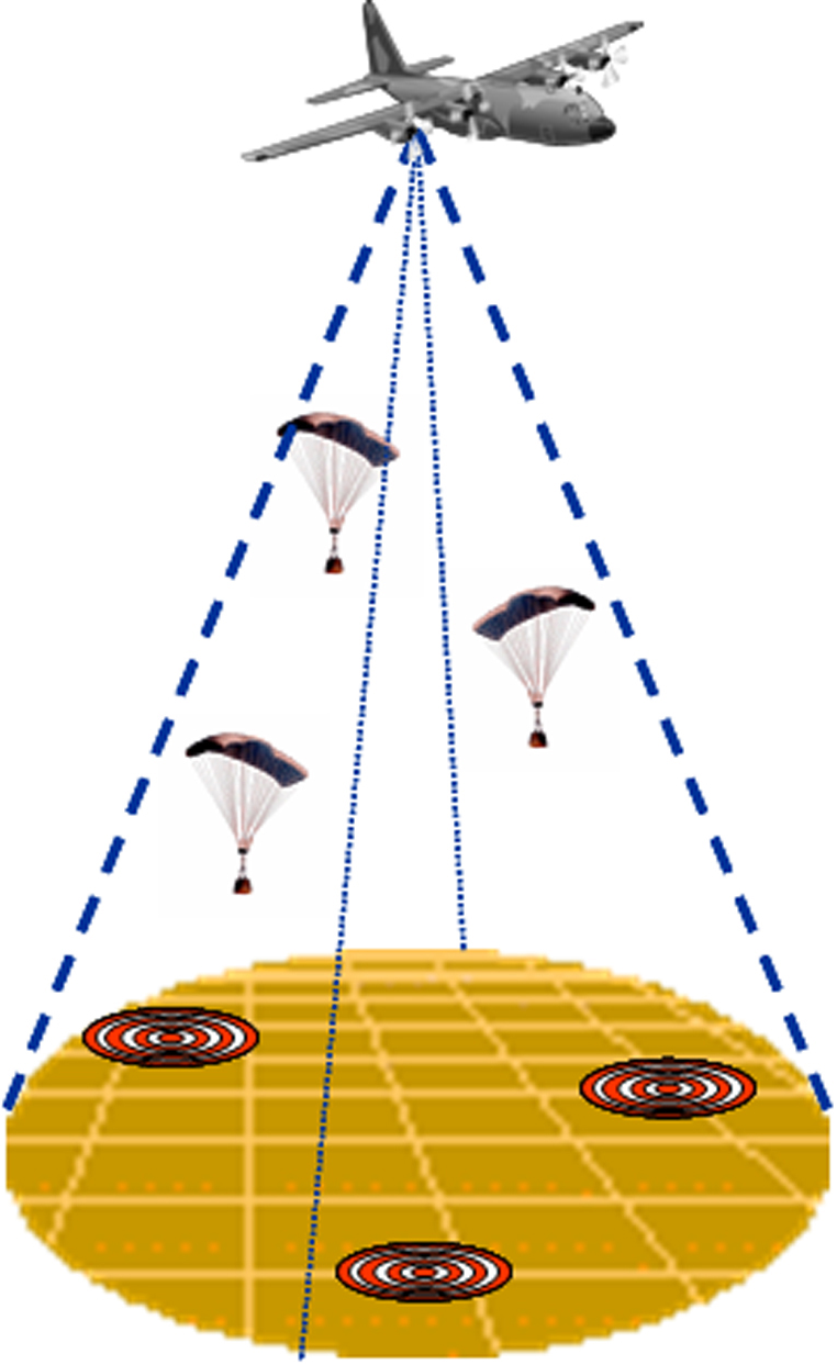
The Joint Precision Airdrop System (JPADS) is an American military airdrop system which uses the Global Positioning System (GPS), steerable parachutes, and an onboard computer to steer loads to a designated point of impact (PI) on a drop zone (DZ). The JPADS family of systems consists of several precision airdrop systems, ranging from extra light to heavy payloads. JPADS is used in conjunction with mission planning software that resides on a laptop. The function of this mission planning software includes computing release points, weather forecasting, acquiring measurements of wind velocity, altitude, air pressure, and temperature. It can also receive weather updates and en route mission changes through satellite links.
U.S. Army Research, Development and Engineering Command (RDECOM) was the primary developer for JPADS, which meets several requirements: increased ground accuracy, standoff delivery, increased air carrier survivability, and improved effectiveness/assessment feedback regarding airdrop mission operations. The U.S. Army and U.S. Air Force began jointly developing this system in 1993. The U.S. Air Force made its first operational/combat use of the system in Afghanistan in 2006.
The steerable parachute or parafoil is called a "decelerator," and gives the JPADS system directional control throughout its descent by means of decelerator steering lines attached to the Autonomous Guidance Unit (AGU). They create drag on either side of the decelerator, which turns the parachute, thus achieving directional control.
The AGU contains a GPS, a battery pack, and the guidance, navigation and control (GN&C) software package. It also houses the hardware required to operate the steering lines. The AGU obtains its position prior to exiting the aircraft, and continues to calculate its position via the GPS throughout descent.
The Mission Planner software gives the aircrew the ability to plan the mission, in flight if necessary, as well as steer the aircraft to its Computed Air Release Point (CARP), where the load is released.
JPADS involves four increments, categorized by the weight of the cargo to be dropped:
Increment I: JPADS-2K / applies to loads up to 2,200 lb / classified as the “extra light” category / commensurate with Container Delivery System (CDS) bundles.
Increment II: JPADS-10K / applies to loads up to 10,000 lb.
Joint Precision Airdrop System
The Joint Precision Airdrop System (JPADS) is an American military airdrop system which uses the Global Positioning System (GPS), steerable parachutes, and an onboard computer to steer loads to a designated point of impact (PI) on a drop zone (DZ). The JPADS family of systems consists of several precision airdrop systems, ranging from extra light to heavy payloads. JPADS is used in conjunction with mission planning software that resides on a laptop. The function of this mission planning software includes computing release points, weather forecasting, acquiring measurements of wind velocity, altitude, air pressure, and temperature. It can also receive weather updates and en route mission changes through satellite links.
U.S. Army Research, Development and Engineering Command (RDECOM) was the primary developer for JPADS, which meets several requirements: increased ground accuracy, standoff delivery, increased air carrier survivability, and improved effectiveness/assessment feedback regarding airdrop mission operations. The U.S. Army and U.S. Air Force began jointly developing this system in 1993. The U.S. Air Force made its first operational/combat use of the system in Afghanistan in 2006.
The steerable parachute or parafoil is called a "decelerator," and gives the JPADS system directional control throughout its descent by means of decelerator steering lines attached to the Autonomous Guidance Unit (AGU). They create drag on either side of the decelerator, which turns the parachute, thus achieving directional control.
The AGU contains a GPS, a battery pack, and the guidance, navigation and control (GN&C) software package. It also houses the hardware required to operate the steering lines. The AGU obtains its position prior to exiting the aircraft, and continues to calculate its position via the GPS throughout descent.
The Mission Planner software gives the aircrew the ability to plan the mission, in flight if necessary, as well as steer the aircraft to its Computed Air Release Point (CARP), where the load is released.
JPADS involves four increments, categorized by the weight of the cargo to be dropped:
Increment I: JPADS-2K / applies to loads up to 2,200 lb / classified as the “extra light” category / commensurate with Container Delivery System (CDS) bundles.
Increment II: JPADS-10K / applies to loads up to 10,000 lb.
Recent media
Recent media