Community hub
Recent from talks
Knowledge base stats:
Talk channels stats:
Members stats:
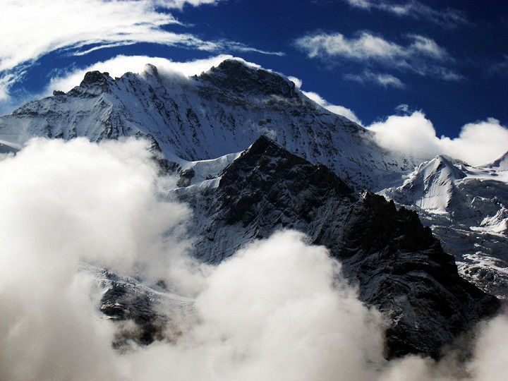
Jungfrau
The Jungfrau (/ˈjʊŋfraʊ/ YOONG-frow), at 4,158 m (13,642 ft) is one of the main summits of the Bernese Alps, located between the southern canton of Bern and the northern canton of Valais, halfway between Interlaken and Fiesch. Together with the Eiger and Mönch, the Jungfrau forms a massive wall of mountains overlooking the Bernese Oberland and the Swiss Plateau, one of the most distinctive sights of the Swiss Alps.
The summit was first reached on 3 August 1811, by the Meyer brothers of Aarau and two chamois hunters from Valais. The ascent followed a long expedition over the glaciers and high passes of the Bernese Alps. It was not until 1865 that a more direct route on the northern side was opened.
The construction of the Jungfrau Railway in the early 20th century, which connects Kleine Scheidegg to the Jungfraujoch, the saddle between the Mönch and the Jungfrau, made the area one of the most-visited places in the Alps. Along with the Aletsch Glacier to the south, the Jungfrau is part of the Jungfrau-Aletsch area, which was declared a World Heritage Site in 2001.
The name Jungfrau ('maiden, virgin'), which refers to the highest of the three prominent mountains overlooking the Interlaken region, along with the Mönch ('monk') and the Eiger ('ogre'), is most likely derived from the name Jungfrauenberg given to Wengernalp, the alpine meadow directly facing the huge northern side of the Jungfrau, across the Trummelbach gorge. Wengernalp was so named for the nuns of Interlaken Monastery, its historical owner. Contrary to popular belief, the name did not originate from the appearance of the snow-covered mountain, the latter looking like a veiled woman.
The "virgin" peak was heavily romanticized as "goddess" or "priestess" in late 18th to 19th century Romanticism. Its summit, considered inaccessible, remained untouched until the 19th century. After the first ascent in 1811 by Swiss alpinist Johann Rudolf Meyer, the peak was jokingly referred to as "Mme Meyer" (Mrs. Meyer).
Politically, the Jungfrau (and its massif) is split between the municipalities of Lauterbrunnen (canton of Bern) and Fieschertal (canton of Valais). It is the third-highest mountain of the Bernese Alps after the nearby Finsteraarhorn 12.3 km (7.6 miles) to the east and Aletschhorn 8.1 km (5.0 miles) to the south, respectively. But from Lake Thun, and the greater part of the canton of Bern, it is the most conspicuous and the nearest of the Bernese Oberland peaks; with a height difference of 3,600 m (11,800 ft) between the summit and the town of Interlaken. This, and the extreme steepness of the north face, secured for it an early reputation for inaccessibility.
The Jungfrau is the highest point of a gigantic 10 km (6.2 miles) wall dominating the valleys of Lauterbrunnen and Grindelwald. The wall is formed by the alignment of some of the biggest north faces in the Alps, with the Mönch (4,107 m, 13,474 ft) and Eiger (3,967 m, 13,015 ft) to the northeast of the Jungfrau, and overlooks the valleys to its west and north by a height of up to 3 km (2 miles). The Jungfrau is approximately 5.3 km (3.3 miles) from the Eiger; with the summit of the Mönch between the two mountains, 3 km (2 miles) from the Jungfrau. The Jungfraujoch is the saddle between the Jungfrau and the Mönch and the Eigerjoch is the saddle between the Mönch and the Eiger.
The wall is extended to the general southwest by over a distance of about 14 km (8.7 miles) as far as to the Tschingelhoren (3,555 m, 11,663 ft) with the Lauterbrunnen Wall on its second half overlooking the beginning of the Lauterbrunnen Valley to the north.
Hub AI
Jungfrau AI simulator
(@Jungfrau_simulator)
Jungfrau
The Jungfrau (/ˈjʊŋfraʊ/ YOONG-frow), at 4,158 m (13,642 ft) is one of the main summits of the Bernese Alps, located between the southern canton of Bern and the northern canton of Valais, halfway between Interlaken and Fiesch. Together with the Eiger and Mönch, the Jungfrau forms a massive wall of mountains overlooking the Bernese Oberland and the Swiss Plateau, one of the most distinctive sights of the Swiss Alps.
The summit was first reached on 3 August 1811, by the Meyer brothers of Aarau and two chamois hunters from Valais. The ascent followed a long expedition over the glaciers and high passes of the Bernese Alps. It was not until 1865 that a more direct route on the northern side was opened.
The construction of the Jungfrau Railway in the early 20th century, which connects Kleine Scheidegg to the Jungfraujoch, the saddle between the Mönch and the Jungfrau, made the area one of the most-visited places in the Alps. Along with the Aletsch Glacier to the south, the Jungfrau is part of the Jungfrau-Aletsch area, which was declared a World Heritage Site in 2001.
The name Jungfrau ('maiden, virgin'), which refers to the highest of the three prominent mountains overlooking the Interlaken region, along with the Mönch ('monk') and the Eiger ('ogre'), is most likely derived from the name Jungfrauenberg given to Wengernalp, the alpine meadow directly facing the huge northern side of the Jungfrau, across the Trummelbach gorge. Wengernalp was so named for the nuns of Interlaken Monastery, its historical owner. Contrary to popular belief, the name did not originate from the appearance of the snow-covered mountain, the latter looking like a veiled woman.
The "virgin" peak was heavily romanticized as "goddess" or "priestess" in late 18th to 19th century Romanticism. Its summit, considered inaccessible, remained untouched until the 19th century. After the first ascent in 1811 by Swiss alpinist Johann Rudolf Meyer, the peak was jokingly referred to as "Mme Meyer" (Mrs. Meyer).
Politically, the Jungfrau (and its massif) is split between the municipalities of Lauterbrunnen (canton of Bern) and Fieschertal (canton of Valais). It is the third-highest mountain of the Bernese Alps after the nearby Finsteraarhorn 12.3 km (7.6 miles) to the east and Aletschhorn 8.1 km (5.0 miles) to the south, respectively. But from Lake Thun, and the greater part of the canton of Bern, it is the most conspicuous and the nearest of the Bernese Oberland peaks; with a height difference of 3,600 m (11,800 ft) between the summit and the town of Interlaken. This, and the extreme steepness of the north face, secured for it an early reputation for inaccessibility.
The Jungfrau is the highest point of a gigantic 10 km (6.2 miles) wall dominating the valleys of Lauterbrunnen and Grindelwald. The wall is formed by the alignment of some of the biggest north faces in the Alps, with the Mönch (4,107 m, 13,474 ft) and Eiger (3,967 m, 13,015 ft) to the northeast of the Jungfrau, and overlooks the valleys to its west and north by a height of up to 3 km (2 miles). The Jungfrau is approximately 5.3 km (3.3 miles) from the Eiger; with the summit of the Mönch between the two mountains, 3 km (2 miles) from the Jungfrau. The Jungfraujoch is the saddle between the Jungfrau and the Mönch and the Eigerjoch is the saddle between the Mönch and the Eiger.
The wall is extended to the general southwest by over a distance of about 14 km (8.7 miles) as far as to the Tschingelhoren (3,555 m, 11,663 ft) with the Lauterbrunnen Wall on its second half overlooking the beginning of the Lauterbrunnen Valley to the north.