Recent from talks
Eiger
Knowledge base stats:
Talk channels stats:
Members stats:
Eiger
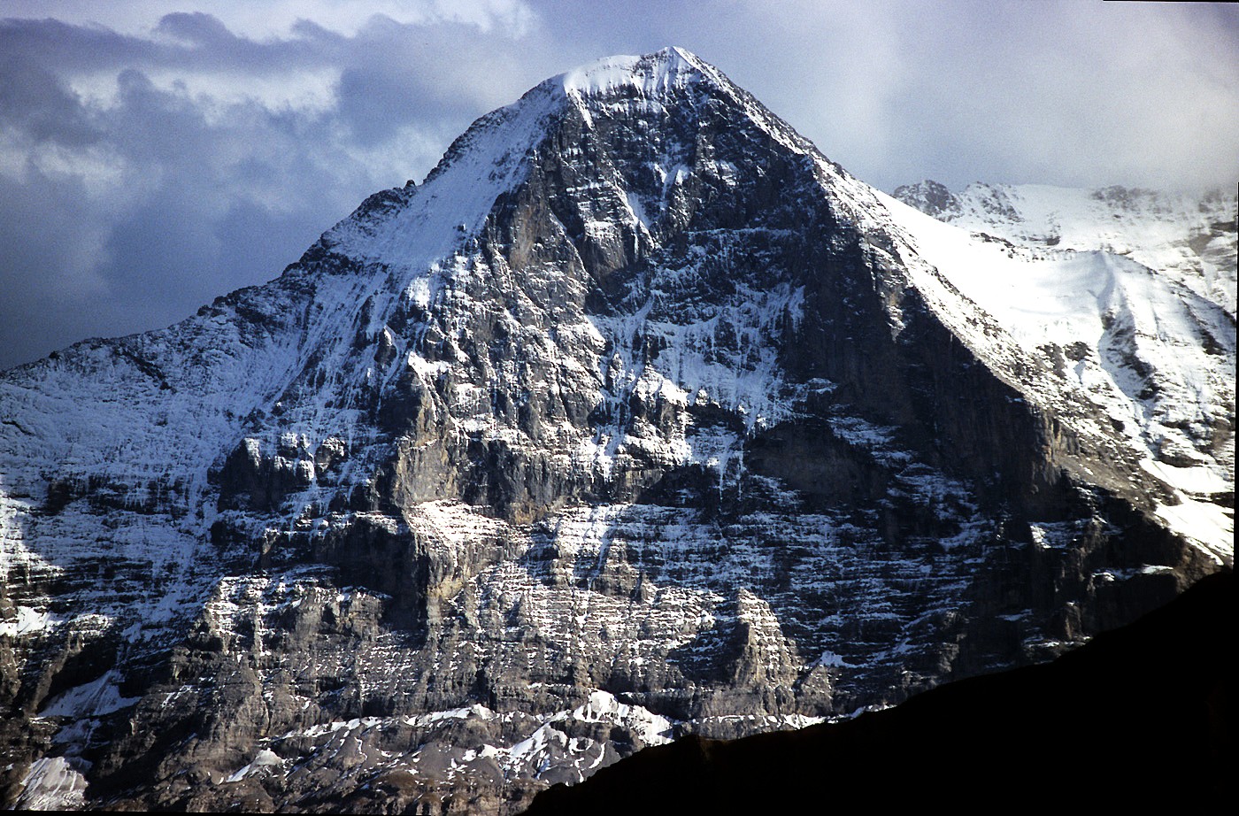
The Eiger (Swiss Standard German pronunciation: [ˈaɪɡər] ⓘ) is a 3,967-metre (13,015 ft) mountain of the Bernese Alps, overlooking Grindelwald and Lauterbrunnen in the Bernese Oberland of Switzerland, just north of the main watershed and border with Valais. It is the easternmost peak of a ridge crest that extends across the Mönch to the Jungfrau at 4,158 m (13,642 ft), constituting one of the most emblematic sights of the Swiss Alps. While the northern side of the mountain rises more than 3,000 m (10,000 ft) above the two valleys of Grindelwald and Lauterbrunnen, the southern side faces the large glaciers of the Jungfrau-Aletsch area, the most glaciated region in the Alps. The most notable feature of the Eiger is its nearly 1,800-metre-high (5,900 ft) north face of rock and ice, named Eiger-Nordwand, Eigerwand or just Nordwand, which is the biggest north face in the Alps. This substantial face towers over the resort of Kleine Scheidegg at its base, on the eponymous pass connecting the two valleys.
The first ascent of the Eiger was made by Swiss guides Christian Almer and Peter Bohren and Irishman Charles Barrington, who climbed the west flank on August 11, 1858. The north face, the "last problem" of the Alps, considered amongst the most challenging and dangerous ascents, was first climbed in 1938 by an Austrian-German expedition. The Eiger has been highly publicized for the many tragedies involving climbing expeditions. Since 1935, at least 64 climbers have died attempting the north face, earning it the German nickname Mordwand, literally "murder(ous) wall"—a pun on its correct title of Nordwand (North Wall).
Although the summit of the Eiger can be reached by experienced climbers only, a railway tunnel runs inside the mountain, and two internal stations provide easy access to viewing-windows carved into the rock face. They are both part of the Jungfrau Railway line, running from Kleine Scheidegg to the Jungfraujoch, between the Mönch and the Jungfrau, at the highest railway station in Europe. The two stations within the Eiger are Eigerwand (behind the north face) and Eismeer (behind the south face), at around 3,000 metres. The Eigerwand station has not been regularly served since 2016.
The first mention of Eiger, appearing as "mons Egere", was found in a property sale document of 1252, but there is no clear indication of how exactly the peak gained its name. The three mountains of the ridge are commonly referred to as the Virgin (German: Jungfrau – translates to "virgin" or "maiden"), the Monk (Mönch), and the Ogre (Eiger; the standard German word for ogre is Oger).
The Eiger is located above the Lauterbrunnen Valley to the west and Grindelwald to the north in the Bernese Oberland region of the canton of Bern. It forms a renowned mountain range of the Bernese Alps together with its two companions: the Jungfrau (4,158 m (13,642 ft)) about 5.6 kilometres (3.5 mi) southwest of it and the Mönch (4,107 m (13,474 ft)) about in the middle of them. The nearest settlements are Grindelwald, Lauterbrunnen (795 m (2,608 ft)) and Wengen (1,274 m (4,180 ft)). The Eiger has three faces: north (or more precisely NNW), east (or more precisely ESE), and west (or more precisely WSW). The northeastern ridge from the summit to the Ostegg (lit.: eastern corner, 2,709 m (8,888 ft)), called Mittellegi, is the longest on the Eiger. The north face overlooks the gently rising Alpine meadow between Grindelwald (943 m (3,094 ft)) and Kleine Scheidegg (2,061 m (6,762 ft)), a mountain railways junction and a pass, which can be reached from both sides, Grindelwald and Lauterbrunnen/Wengen – by foot or train.
Politically, the Eiger (and its summit) belongs to the Bernese municipalities of Grindelwald and Lauterbrunnen. The Kleine Scheidegg (literally, the small parting corner) connects the Männlichen-Tschuggen range with the western ridge of the Eiger. The Eiger does not properly form part of the main chain of the Bernese Alps, which borders the canton of Valais and forms the watershed between the Rhine and the Rhône, but constitutes a massive limestone buttress, projecting from the crystalline basement of the Mönch across the Eigerjoch. Consequently, all sides of the Eiger feed finally the same river, namely the Lütschine.
Eiger's water is connected through the Weisse Lütschine (the white one) in the Lauterbrunnen Valley on the west side (southwestern face of the Eiger) and through the Schwarze Lütschine (the black one) running through Grindelwald (northwestern face), which meet each other in Zweilütschinen (lit.: the two Lütschinen) where they form the proper Lütschine. The east face is covered by the glacier called Ischmeer (Bernese German for Ice Sea), which forms one upper part of the fast-retreating Lower Grindelwald Glacier. These glaciers' water forms a short creek, which is also confusingly called the Weisse Lütschine, but enters the black one already in Grindelwald together with the water from the Upper Grindelwald Glacier. Therefore, all the water running down the Eiger converges at the northern foot of the Männlichen (2,342 m (7,684 ft)) in Zweilütschinen (654 m (2,146 ft)), about 10 kilometres (6.2 mi) northwest of the summit, where the Lütschine begins its northern course to Lake Brienz and the Aare (564 m (1,850 ft)).
Although the Eiger's north face is almost ice-free, significant glaciers lie on the other sides of the mountain. The Eiger Glacier flows on the southwestern side of the Eiger, from the crest connecting it to the Mönch down to 2,400 m (7,900 ft), south of Eigergletscher railway station, and feeds the Weisse Lütschine through the Trümmelbach. On the east side, the Ischmeer–well visible from the windows of Eismeer railway station–flows eastwards from the same crest then turns to the north below the impressive wide Fiescherwand, the north face of the Fiescherhörner triple summit (4,049 m (13,284 ft)) down to about 1,600 m (5,200 ft) of the Lower Grindelwald Glacier system.
Hub AI
Eiger AI simulator
(@Eiger_simulator)
Eiger
The Eiger (Swiss Standard German pronunciation: [ˈaɪɡər] ⓘ) is a 3,967-metre (13,015 ft) mountain of the Bernese Alps, overlooking Grindelwald and Lauterbrunnen in the Bernese Oberland of Switzerland, just north of the main watershed and border with Valais. It is the easternmost peak of a ridge crest that extends across the Mönch to the Jungfrau at 4,158 m (13,642 ft), constituting one of the most emblematic sights of the Swiss Alps. While the northern side of the mountain rises more than 3,000 m (10,000 ft) above the two valleys of Grindelwald and Lauterbrunnen, the southern side faces the large glaciers of the Jungfrau-Aletsch area, the most glaciated region in the Alps. The most notable feature of the Eiger is its nearly 1,800-metre-high (5,900 ft) north face of rock and ice, named Eiger-Nordwand, Eigerwand or just Nordwand, which is the biggest north face in the Alps. This substantial face towers over the resort of Kleine Scheidegg at its base, on the eponymous pass connecting the two valleys.
The first ascent of the Eiger was made by Swiss guides Christian Almer and Peter Bohren and Irishman Charles Barrington, who climbed the west flank on August 11, 1858. The north face, the "last problem" of the Alps, considered amongst the most challenging and dangerous ascents, was first climbed in 1938 by an Austrian-German expedition. The Eiger has been highly publicized for the many tragedies involving climbing expeditions. Since 1935, at least 64 climbers have died attempting the north face, earning it the German nickname Mordwand, literally "murder(ous) wall"—a pun on its correct title of Nordwand (North Wall).
Although the summit of the Eiger can be reached by experienced climbers only, a railway tunnel runs inside the mountain, and two internal stations provide easy access to viewing-windows carved into the rock face. They are both part of the Jungfrau Railway line, running from Kleine Scheidegg to the Jungfraujoch, between the Mönch and the Jungfrau, at the highest railway station in Europe. The two stations within the Eiger are Eigerwand (behind the north face) and Eismeer (behind the south face), at around 3,000 metres. The Eigerwand station has not been regularly served since 2016.
The first mention of Eiger, appearing as "mons Egere", was found in a property sale document of 1252, but there is no clear indication of how exactly the peak gained its name. The three mountains of the ridge are commonly referred to as the Virgin (German: Jungfrau – translates to "virgin" or "maiden"), the Monk (Mönch), and the Ogre (Eiger; the standard German word for ogre is Oger).
The Eiger is located above the Lauterbrunnen Valley to the west and Grindelwald to the north in the Bernese Oberland region of the canton of Bern. It forms a renowned mountain range of the Bernese Alps together with its two companions: the Jungfrau (4,158 m (13,642 ft)) about 5.6 kilometres (3.5 mi) southwest of it and the Mönch (4,107 m (13,474 ft)) about in the middle of them. The nearest settlements are Grindelwald, Lauterbrunnen (795 m (2,608 ft)) and Wengen (1,274 m (4,180 ft)). The Eiger has three faces: north (or more precisely NNW), east (or more precisely ESE), and west (or more precisely WSW). The northeastern ridge from the summit to the Ostegg (lit.: eastern corner, 2,709 m (8,888 ft)), called Mittellegi, is the longest on the Eiger. The north face overlooks the gently rising Alpine meadow between Grindelwald (943 m (3,094 ft)) and Kleine Scheidegg (2,061 m (6,762 ft)), a mountain railways junction and a pass, which can be reached from both sides, Grindelwald and Lauterbrunnen/Wengen – by foot or train.
Politically, the Eiger (and its summit) belongs to the Bernese municipalities of Grindelwald and Lauterbrunnen. The Kleine Scheidegg (literally, the small parting corner) connects the Männlichen-Tschuggen range with the western ridge of the Eiger. The Eiger does not properly form part of the main chain of the Bernese Alps, which borders the canton of Valais and forms the watershed between the Rhine and the Rhône, but constitutes a massive limestone buttress, projecting from the crystalline basement of the Mönch across the Eigerjoch. Consequently, all sides of the Eiger feed finally the same river, namely the Lütschine.
Eiger's water is connected through the Weisse Lütschine (the white one) in the Lauterbrunnen Valley on the west side (southwestern face of the Eiger) and through the Schwarze Lütschine (the black one) running through Grindelwald (northwestern face), which meet each other in Zweilütschinen (lit.: the two Lütschinen) where they form the proper Lütschine. The east face is covered by the glacier called Ischmeer (Bernese German for Ice Sea), which forms one upper part of the fast-retreating Lower Grindelwald Glacier. These glaciers' water forms a short creek, which is also confusingly called the Weisse Lütschine, but enters the black one already in Grindelwald together with the water from the Upper Grindelwald Glacier. Therefore, all the water running down the Eiger converges at the northern foot of the Männlichen (2,342 m (7,684 ft)) in Zweilütschinen (654 m (2,146 ft)), about 10 kilometres (6.2 mi) northwest of the summit, where the Lütschine begins its northern course to Lake Brienz and the Aare (564 m (1,850 ft)).
Although the Eiger's north face is almost ice-free, significant glaciers lie on the other sides of the mountain. The Eiger Glacier flows on the southwestern side of the Eiger, from the crest connecting it to the Mönch down to 2,400 m (7,900 ft), south of Eigergletscher railway station, and feeds the Weisse Lütschine through the Trümmelbach. On the east side, the Ischmeer–well visible from the windows of Eismeer railway station–flows eastwards from the same crest then turns to the north below the impressive wide Fiescherwand, the north face of the Fiescherhörner triple summit (4,049 m (13,284 ft)) down to about 1,600 m (5,200 ft) of the Lower Grindelwald Glacier system.
Recent media