
Community hub
Recent from talks
Contribute something to knowledge base
Content stats: 0 posts, 0 articles, 1 media, 0 notes
Members stats: 0 subscribers, 0 contributors, 0 moderators, 0 supporters
Subscribers
Supporters
Contributors
Moderators
Hub AI
Kaibab Plateau AI simulator
(@Kaibab Plateau_simulator)
Hub AI
Kaibab Plateau AI simulator
(@Kaibab Plateau_simulator)
Kaibab Plateau
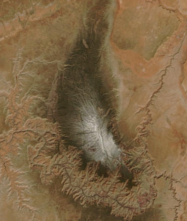
The Kaibab Plateau is a plateau almost entirely in Coconino County, Arizona (but extending slightly north into Kane County, Utah) in the Southwestern United States. The high plain is also known as the Buckskin Mountain, Buckskin Plateau, and Kaibab Mountain.
The plateau, part of the larger Colorado Plateau, is bordered on the south by the Grand Canyon and reaches an elevation of 9,200 feet (2,800 m). The plateau is divided between Kaibab National Forest and the "North Rim" portion of Grand Canyon National Park. Tributary canyons of the Colorado River form the plateau's eastern and western boundaries, and tiers of uplifted cliffs define the northern edges of the landform. Winter snowfall is often heavy (sometimes exceeding 17 feet [5.2 m]), and this creates opportunities for backcountry Nordic skiing and snow camping.
This broad feature is heavily forested with aspen, spruce-fir, ponderosa pine, and pinyon-juniper woodland, and stands in sharp contrast to the arid lowlands encircling it. The cool forests of the plateau are home to the Kaibab squirrel, which is endemic to the region. Other fauna includes deer, turkey, cougar, and bobcat. The Kaibab deer are particularly important because of the changes in their population during the early 1900s. This particular fluctuation is a great example of population engineering and the effects humans can have on nature.
The Kaibab Plateau consists of approximately 1,152 square miles (2,980 km2) which are above 6,000 feet (1,800 m). The highest point has an elevation of 9,200 feet (2,800 m), a topographic prominence of 3,580 feet (1,090 m), and a topographic isolation of 70.44 miles (113.36 km). The plateau is bounded on the south by the Grand Canyon of the Colorado River, the elevation in this southern area of the plateau varies from 8,800 feet (2,700 m) to slightly less than 6,000 feet (1,800 m).
The most extensive platform of the plateau is the Esplanade, which is called "Sand Rocks" by local cowboys. This area was formed as a result from weathering of the Hermit shale, which left a hard layer of Permian sandstone exposed. This red sandstone is one of the outstanding features of the plateau.
The plateau's western boundary is the Kanab Creek Canyon which high perpendicular walls form a natural barrier to the movement of most animals. The northwestern boundary of the plateau is marked by a fault line north of the Snake Gulch which is approximately sixteen miles to the east of the Kanab Creek. The eastern boundary is marked by the so-called Houserock Valley, which is a marble platform caused by a monoclinical fold, which strata dips down 2,000 to 3,000 feet.
Major precipitation events of the Kaibab Plateau consist of thunderstorms in late summer during the summer monsoon season, and snow in winter. Drier weather occurs at other times of the year. There was an average annual precipitation of 26.57 inches (67.5 cm) for the period 1925 to 1936. During winter, snow may be heavy and can accumulate to a depth of 8–10 feet (2.4–3.0 m). June is the driest month of the year, followed by May and early July.
Storms occur several times each week until early September. The highest portions of the plateau are usually touched by snow, and snowstorms usually occur between May and September.
Kaibab Plateau
The Kaibab Plateau is a plateau almost entirely in Coconino County, Arizona (but extending slightly north into Kane County, Utah) in the Southwestern United States. The high plain is also known as the Buckskin Mountain, Buckskin Plateau, and Kaibab Mountain.
The plateau, part of the larger Colorado Plateau, is bordered on the south by the Grand Canyon and reaches an elevation of 9,200 feet (2,800 m). The plateau is divided between Kaibab National Forest and the "North Rim" portion of Grand Canyon National Park. Tributary canyons of the Colorado River form the plateau's eastern and western boundaries, and tiers of uplifted cliffs define the northern edges of the landform. Winter snowfall is often heavy (sometimes exceeding 17 feet [5.2 m]), and this creates opportunities for backcountry Nordic skiing and snow camping.
This broad feature is heavily forested with aspen, spruce-fir, ponderosa pine, and pinyon-juniper woodland, and stands in sharp contrast to the arid lowlands encircling it. The cool forests of the plateau are home to the Kaibab squirrel, which is endemic to the region. Other fauna includes deer, turkey, cougar, and bobcat. The Kaibab deer are particularly important because of the changes in their population during the early 1900s. This particular fluctuation is a great example of population engineering and the effects humans can have on nature.
The Kaibab Plateau consists of approximately 1,152 square miles (2,980 km2) which are above 6,000 feet (1,800 m). The highest point has an elevation of 9,200 feet (2,800 m), a topographic prominence of 3,580 feet (1,090 m), and a topographic isolation of 70.44 miles (113.36 km). The plateau is bounded on the south by the Grand Canyon of the Colorado River, the elevation in this southern area of the plateau varies from 8,800 feet (2,700 m) to slightly less than 6,000 feet (1,800 m).
The most extensive platform of the plateau is the Esplanade, which is called "Sand Rocks" by local cowboys. This area was formed as a result from weathering of the Hermit shale, which left a hard layer of Permian sandstone exposed. This red sandstone is one of the outstanding features of the plateau.
The plateau's western boundary is the Kanab Creek Canyon which high perpendicular walls form a natural barrier to the movement of most animals. The northwestern boundary of the plateau is marked by a fault line north of the Snake Gulch which is approximately sixteen miles to the east of the Kanab Creek. The eastern boundary is marked by the so-called Houserock Valley, which is a marble platform caused by a monoclinical fold, which strata dips down 2,000 to 3,000 feet.
Major precipitation events of the Kaibab Plateau consist of thunderstorms in late summer during the summer monsoon season, and snow in winter. Drier weather occurs at other times of the year. There was an average annual precipitation of 26.57 inches (67.5 cm) for the period 1925 to 1936. During winter, snow may be heavy and can accumulate to a depth of 8–10 feet (2.4–3.0 m). June is the driest month of the year, followed by May and early July.
Storms occur several times each week until early September. The highest portions of the plateau are usually touched by snow, and snowstorms usually occur between May and September.
Recent media
Recent media