

Community hub
0 subscribers8 pages, 0 posts
Recent from talks
All channels
Be the first to start a discussion here.
Be the first to start a discussion here.
Be the first to start a discussion here.
Be the first to start a discussion here.
Contribute something
Welcome to the community hub built to collect knowledge and have discussions related to Topographic isolation.
Nothing was collected or created yet.
Topographic isolation
View on Wikipediafrom Wikipedia

A - Nearest higher neighbour
The topographic isolation of a summit is the minimum horizontal distance to a point of equal elevation, representing a radius of dominance in which the peak is the highest point. It can be calculated for small hills and islands as well as for major mountain peaks and can even be calculated for submarine summits. Mount Everest, the highest point on Earth, has an undefined isolation, since there are no higher points to reference.[1]
Because topographic isolation can be difficult to determine, a common approximation is the distance to a peak called the nearest higher neighbour (NHN).[2]
Isolation table
[edit]The following sortable table lists Earth's 40 most topographically isolated summits.
| Rank | Summit | Landmass | Country | Elevation | Prominence | Isolation | Nearest higher neighbour |
|---|---|---|---|---|---|---|---|
| 1 | Mount Everest | Eurasia | 8848 m 29,029 ft |
8848 m 29,029 ft |
n/a | n/a | |
| 2 | Aconcagua | South America | 6962 m 22,841 ft |
6962 m 22,841 ft |
16,520 km 10,265 mi |
Tirich Mir (Khyber Pakhtunkhwa, Pakistan) | |
| 3 | Denali (Mount McKinley) | North America | 6194 m 20,320 ft |
6149 m 20,174 ft |
7,450 km 4,629 mi |
Yanamax (Xinjiang, China) | |
| 4 | Kilimanjaro | Africa | 5895 m 19,341 ft |
5885 m 19,308 ft |
5,510 km 3,424 mi |
Kuh-e Shashgal (Afghanistan) | |
| 5 | Puncak Jaya | New Guinea | 4884 m 16,024 ft |
4884 m 16,024 ft |
5,262 km 3,269 mi |
Jade Dragon Snow Mountain (Yunnan, China) | |
| 6 | Vinson Massif | Antarctica | 4892 m 16,050 ft |
4892 m 16,050 ft |
4,861 km 3,020 mi |
Risco Plateado (Mendoza, Argentina) | |
| 7 | Mont Orohena | Tahiti | 2241 m 7,352 ft |
2241 m 7,352 ft |
4,128 km 2,565 mi |
Mount Ngauruhoe (New Zealand) | |
| 8 | Mauna Kea | Hawai'i | 4205 m 13,796 ft |
4205 m 13,796 ft |
3,947 km 2,453 mi |
Mount Shasta (California, US) | |
| 9 | Gunnbjørn Fjeld | Greenland | 3694 m 12,119 ft |
3694 m 12,119 ft |
3,254 km 2,022 mi |
The Eiger (Canton of Bern, Switzerland) | |
| 10 | Aoraki / Mount Cook | South Island | 3754 m 12,316 ft |
3754 m 12,316 ft |
3,140 km 1,951 mi |
Mount Adam (Victoria Land, Antarctica) | |
| 11 | Thabana Ntlenyana | Africa | 3482 m 11,424 ft |
2390 m 7,841 ft |
3,003 km 1,866 mi |
Mount Meru (Tanzania) | |
| 12 | Maunga Terevaka | Easter Island | 506 m 1,660 ft |
506 m 1,660 ft |
2,836 km 1,762 mi |
Cerro de Los Inocentes (Alejandro Selkirk Island, Chile) | |
| 13 | Mont Blanc | Eurasia | 4809 m 15,778 ft |
4696 m 15,407 ft |
2,813 km 1,748 mi |
Kukurtlu Dome (Karachay-Cherkessia, Russia) | |
| 14 | Piton des Neiges | Réunion | 3071 m 10,075 ft |
3071 m 10,075 ft |
2,767 km 1,720 mi |
Giant's Castle (KwaZulu-Natal, South Africa) | |
| 15 | Klyuchevskaya Sopka | Eurasia | 4750 m 15,584 ft |
4649 m 15,253 ft |
2,748 km 1,708 mi |
Mount Foraker (Alaska, US) | |
| 16 | Pico de Orizaba | North America | 5636 m 18,491 ft |
4922 m 16,148 ft |
2,690 km 1,672 mi |
Pico Cristóbal Colón (Magdalena Department, Colombia) | |
| 17 | Queen Mary's Peak | Tristan da Cunha | 2060 m 6,759 ft |
2060 m 6,759 ft |
2,665 km 1,656 mi |
Mount Paget (South Georgia Island, UK) | |
| 18 | Mount Whitney | North America | 4421 m 14,505 ft |
3072 m 10,080 ft |
2,649 km 1,646 mi |
Nevado de Toluca (State of Mexico, Mexico) | |
| 19 | Gunung Kinabalu | Borneo | 4095 m 13,435 ft |
4095 m 13,435 ft |
2,538 km 1,577 mi |
Ngga Pilimsit (Papua, Indonesia) | |
| 20 | Mount Elbrus | Eurasia | 5642 m 18,510 ft |
4741 m 15,554 ft |
2,473 km 1,536 mi |
Pik Agasis (Tajikistan) | |
| 21 | Pico da Bandeira | South America | 2897 m 9,505 ft |
2647 m 8,684 ft |
2,393 km 1,487 mi |
Cerro Naranjos (Bolivia) | |
| 22 | Mont Cameroun | Africa | 4040 m 13,255 ft |
3901 m 12,799 ft |
2,338 km 1,453 mi |
Mikeno (Democratic Republic of the Congo) | |
| 23 | Mount Paget | South Georgia | 2915 m 9,564 ft |
2915 m 9,564 ft |
2,269 km 1,410 mi |
Welch Mountains (Palmer Land, Antarctica) | |
| 24 | Mauga Silisili | Savai'i | 1858 m 6,096 ft |
1858 m 6,096 ft |
2,245 km 1,395 mi |
Tabwemasana (Vanuatu) | |
| 25 | Nevado Huascarán | South America | 6746 m 22,133 ft |
2776 m 9,108 ft |
2,196 km 1,365 mi |
Tres Cruces (Chile/Argentina border) | |
| 26 | Anamudi | Eurasia | 2695 m 8,842 ft |
2480 m 8,136 ft |
2,115 km 1,314 mi |
Machapuchare (Nepal) | |
| 27 | Jebel Toubkal | Africa | 4167 m 13,671 ft |
3755 m 12,320 ft |
2,078 km 1,291 mi |
Picco Luigi Amedeo (Italy) | |
| 28 | Mount Fuji | Honshu | 3776 m 12,388 ft |
3776 m 12,388 ft |
2,077 km 1,291 mi |
Xueshan (Taiwan) | |
| 29 | Emi Koussi | Africa | 3445 m 11,302 ft |
2934 m 9,626 ft |
2,001 km 1,243 mi |
Mount Cameroon (Cameroon) | |
| 30 | Mawson Peak | Heard Island | 2745 m 9,006 ft |
2745 m 9,006 ft |
1,922 km 1,194 mi |
Mount McMaster (Enderby Land, Antarctica) | |
| 31 | Mount Mitchell | North America | 2037 m 6,684 ft |
1857 m 6,091 ft |
1,913 km 1,189 mi |
Lone Butte (Colorado, US) | |
| 32 | Gunung Kerinci | Sumatra | 3805 m 12,484 ft |
3805 m 12,484 ft |
1,905 km 1,184 mi |
Gunung Kinabalu (Sabah, Malaysia) | |
| 33 | Joe's Hill | Kiritimati | 13 m 43 ft |
13 m 43 ft |
1,903 km 1,182 mi |
Puu Ki (Hawaii, US) | |
| 34 | Agrihan High Point | Agrihan | 965 m 3,166 ft |
965 m 3,166 ft |
1,902 km 1,182 mi |
Mount Amagi (Chūbu, Japan) | |
| 35 | Mount Kosciuszko | Australia | 2228 m 7,310 ft |
2228 m 7,310 ft |
1,895 km 1,177 mi |
Tutoko (New Zealand) | |
| 36 | Olavtoppen | Bouvet Island | 780 m 2,559 ft |
780 m 2,559 ft |
1,856 km 1,153 mi |
Edinburgh Peak (Gough Island, South Atlantic Ocean) | |
| 37 | Mascarin Peak | Marion Island | 1230 m 4,035 ft |
1230 m 4,035 ft |
1,848 km 1,148 mi |
Cockscomb (Eastern Cape, South Africa) | |
| 38 | Green Mountain | Ascension Island | 859 m 2,818 ft |
859 m 2,818 ft |
1,842 km 1,145 mi |
Mount Richard-Molard (Ivory Coast/Guinea border) | |
| 39 | Gora Narodnaya | Eurasia | 1895 m 6,217 ft |
1772 m 5,814 ft |
1,836 km 1,141 mi |
Kattotjåkkå (Sweden) | |
| 40 | Yushan | Taiwan | 3952 m 12,966 ft |
3952 m 12,966 ft |
1,815 km 1,128 mi |
Peak 4030 (Yunnan, China) |
Examples
[edit]- The nearest peak to Germany's highest mountain, the 2,962-metre (9,718 ft) high Zugspitze, that has a 2,962-metre (9,718 ft) contour is the 2,988-metre (9,803 ft) Zwölferkogel in Austria's Stubai Alps. The distance between the Zugspitze and this contour is 25.8 kilometres (16 mi); the Zugspitze is thus the highest peak for a radius of 25.8 kilometres (16 mi). Its isolation is thus 25.8 kilometres (16 mi).
- Because there are no higher mountains than Mount Everest, it has no definitive isolation. Many sources list its isolation as the circumference of the Earth over the poles or – questionably, because there is no agreed definition – as half the Earth's circumference.
- After Mount Everest, Aconcagua, the highest mountain of the Americas, has the greatest isolation of all mountains. There is no higher land for 16,534 kilometres (10,274 mi). Its height is first exceeded by Tirich Mir in the Hindu Kush.
- Mont Blanc is the highest mountain of the Alps. The geographically nearest higher mountains are all in the Caucasus. Kukurtlu Dome, 4,978 metres (16,332 ft), is the reference peak for Mont Blanc.
- Musala is the highest peak in Rila mountain, also in Bulgaria and the Balkan Peninsula mountain system; standing at 2,925 m (9,596 ft) it is the fourth-most topographically isolated major peak in Continental Europe.[3] With a topographic prominence of 2,473 metres (8,114 ft), Musala is also the sixth-highest peak by topographic prominence in mainland Europe.[4]
Gallery
[edit]-
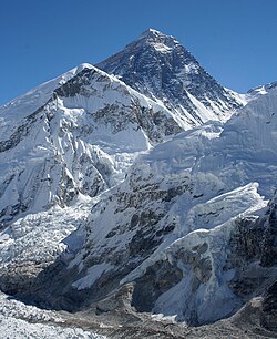 1. Mount Everest is the highest mountain peak on Earth.
 -
-
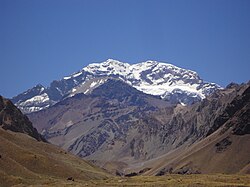
 3. Denali is the highest peak of North America.
 -
 4. Kilimanjaro is the highest peak of Africa.
 -

-
 6. The Vinson Massif is the highest peak of Antarctica.
 -

-
 8. Mauna Kea on the Island of Hawaiʻi is the tallest mountain on Earth as measured from base on seafloor to summit.
 -

-

-
 11. Thabana Ntlenyana in Lesotho is the highest point in southern Africa.
 -
 12. Ma′unga Terevaka is the highest point on Easter Island.
 -
 13. Mont Blanc is the highest peak of Western Europe.
 -
 14. Piton des Neiges is the apex of Réunion.
 -
 15. Klyuchevskaya Sopka is the highest peak of Kamchatka.
 -
 16. Pico de Orizaba is the highest peak of Mexico.
 -
 17. Queen Mary's Peak is the highest point on the Atlantic island of Tristan da Cunha.
 -
 18. Mount Whitney is the highest peak of the contiguous United States.
 -
 19. Gunung Kinabalu is the apex of Borneo.
 -
 20. Mount Elbrus is the highest peak of Europe.
 -
 21. Pico da Bandeira is the third highest peak of Brazil.
 -
 22. Mount Cameroon is the highest peak of Cameroon.
 -


See also
[edit]References
[edit]- ^ Kirmse, Andrew; de Ferranti, Jonathan (December 2017). "Calculating the prominence and isolation of every mountain in the world". Progress in Physical Geography: Earth and Environment. 41 (6): 788–802. doi:10.1177/0309133317738163. Retrieved 8 May 2024.
- ^ Nearest higher neighbour in glossary on www.peakbagger.com
- ^ "Most Isolated Peak of Europe Countries - Peakbagger.com".
- ^ "Europe Ultra-Prominences". Peaklist. Retrieved 26 February 2015.
External links
[edit]Topographic isolation
View on Grokipediafrom Grokipedia
Topographic isolation is a key metric in physical geography and mountaineering that measures the degree of separation of a mountain summit from higher terrain, defined as the minimum great-circle distance along the Earth's surface to the nearest point of equal or greater elevation, known as the isolation limit point (ILP).[1][2] This distance represents the radius of dominance around the summit, within which it stands as the highest feature, and is typically calculated using digital elevation models (DEMs) via algorithms that identify peaks and query the closest higher terrain.[1][2]
Distinct from topographic prominence—which quantifies a summit's independent rise above the lowest contour line encircling it and connecting it to higher ground—isolation emphasizes horizontal separation rather than vertical height, providing insight into a peak's regional dominance and scenic isolation.[1][2] For the Earth's highest summit, Mount Everest, isolation is considered infinite or undefined due to the absence of any higher point, underscoring its unparalleled status, while other notable peaks like Aconcagua in Argentina exhibit extreme values exceeding 16,500 km to the nearest higher terrain in Asia.[3][3] This metric is widely applied in compiling global rankings of isolated summits, aiding mountaineers and geographers in assessing a peak's uniqueness.[2][1]
[3]
Definition and Concepts
Definition
Topographic isolation is a metric used in geography to quantify the horizontal separation of a mountain summit from surrounding terrain, specifically defined as the minimum distance from the summit to the nearest point of higher elevation. This distance represents the radius of dominance for the summit, delineating a circular area centered on the peak within which it stands as the highest point, with no intervening terrain exceeding its elevation.[2][4] The key concept in this measurement is the isolation limit point, which is the closest location on the Earth's surface where the elevation is higher than that of the summit, often determined along a great circle path or straight-line horizontal distance on topographic maps. This point typically occurs on a ridge, col, or slope leading to another higher feature, establishing the boundary beyond which the summit's dominance ends. The horizontal nature of topographic isolation relies on fundamental prerequisites such as the summit's elevation above sea level and the geodesic distance calculation, ensuring it captures spatial independence without considering vertical rise.[2][4] As a horizontal counterpart to topographic prominence—a vertical measure of a summit's rise above the lowest connecting saddle to a higher peak—topographic isolation emphasizes lateral extent and regional uniqueness in assessing a mountain's standalone character.[2]Relation to Topographic Prominence
Topographic isolation and prominence are complementary metrics that together provide a fuller assessment of a peak's topographic independence from surrounding terrain. While prominence quantifies the vertical rise of a summit above the lowest contour line encircling it and containing no higher summit—essentially measuring the minimum descent required to reach higher terrain—isolation captures the horizontal separation to the nearest point of equal or greater elevation. This distinction allows prominence to emphasize vertical relief, rewarding peaks with significant local height dominance, whereas isolation highlights geographic remoteness, indicating the radius within which a summit reigns supreme without competition from taller neighbors.[2][5] When used in combination, these metrics reveal nuances in peak classification; for instance, ultra-prominent peaks, defined by a prominence threshold of 1,500 meters, frequently exhibit substantial isolation due to their substantial vertical separation, yet this correlation is not absolute. Peaks in low-relief landscapes can achieve high isolation through vast horizontal distances to higher terrain despite modest prominence, while conversely, some highly prominent summits may cluster closely with others in rugged, densely packed ranges. Such combined evaluations, often through products of prominence and isolation values, aid in identifying uniquely dominant features beyond elevation alone.[6] Both concepts gained prominence in mountaineering circles during the 1990s, driven by enthusiasts compiling comprehensive lists to expand beyond mere elevation-based rankings. Communities like the Highpointers Club and the Ultra Project, led by figures such as Jonathan de Ferranti and Aaron Maizlish, popularized these metrics through databases and publications that cataloged thousands of peaks worldwide, fostering their adoption in peak-bagging activities.[5] A notable parallel arises at the global scale: the isolation of the Earth's highest summit, such as Mount Everest, is considered infinite, as no higher point exists, mirroring how its prominence is measured relative to sea level as the ultimate key col. This symmetry underscores their shared role in defining ultimate topographic sovereignty.[2]Measurement and Calculation
Determining Isolation Distance
To determine the isolation distance of a summit, the process begins with identifying the peak's precise location using a topographic map, contour lines, or geographic coordinates. From this starting point, the minimum great-circle distance along the Earth's surface is found to the nearest point of equal or greater elevation, known as the isolation limit point (ILP). This point is located by considering the lowest-elevation path to higher terrain, where the key col—the lowest saddle point on the ridge connecting the summit to higher terrain—helps identify the direction, but the isolation is the direct distance to the ILP. Contour maps facilitate visualization of elevation changes to approximate this distance manually.[2] For summits near oceans or seas, since water bodies are below the summit's elevation, the isolation distance is measured across them to the nearest point of equal or greater elevation on another landmass. This horizontal, as-the-crow-flies measurement ignores vertical rise and focuses solely on great-circle distance along the Earth's surface.[2] Edge cases require specific handling: the global highest points, such as Mount Everest, exhibit infinite isolation since no point of equal or greater elevation exists anywhere on Earth. Conversely, non-summit locations, like points on a slope or ridge below a peak, have a minimum isolation of zero, as an infinitesimally close higher point is always available. The isolation distance is typically computed using the haversine formula for geodesic distance (as detailed in the computational approaches below), though for small distances, a planar approximation using projected coordinates may suffice: where and are projected horizontal coordinates of the summit and ILP.[2]Computational Approaches
Computational approaches to topographic isolation leverage digital elevation models (DEMs) to enable automated, large-scale calculations across vast terrains, contrasting with manual methods by processing gridded elevation data systematically. These methods typically begin by identifying candidate peaks as local maxima in the DEM, then determine isolation by measuring the minimum great-circle distance to any higher elevation point. Widely used DEMs include the Shuttle Radar Topography Mission (SRTM) dataset at approximately 30-meter resolution and the Advanced Spaceborne Thermal Emission and Reflection Radiometer (ASTER) Global DEM at similar resolution, both providing near-global coverage suitable for elevation-based analyses.[1] Core algorithms employ radial or directional searches from each peak to locate the nearest higher terrain, often optimized for efficiency on massive datasets. A basic radial search expands outward in concentric circles or rays until encountering higher ground, but for global scales involving billions of grid points, more advanced techniques like the sweep-plane algorithm reduce complexity from O(n²) to O(n log n + p T_{NN}), where n is the number of points, p is the number of peaks, and T_{NN} is the nearest-neighbor query time. This involves sweeping a plane across the DEM to maintain active contour lines in a geometric data structure, enabling efficient isolation limit point identification even at high resolutions like 12 meters. Such algorithms, implemented in parallel, handle the spherical geometry of Earth by computing distances via the haversine formula: where are latitudes, and are differences in latitude and longitude, and is Earth's mean radius (approximately 6371 km). This formula ensures accurate geodesic distances, essential for peaks separated by hundreds of kilometers.[1] Software tools and databases facilitate these computations, often integrating DEM processing with geographic information systems (GIS). Edward Earl's WinProm, developed in 1998, pioneered automated prominence and isolation calculations from DEMs using topological approaches, influencing subsequent global efforts. Online platforms like Peakbagger.com employ similar algorithms to catalog isolations for thousands of peaks, drawing on SRTM and refined datasets. For broader analysis, open-source GIS tools such as QGIS or custom Python scripts with libraries like GDAL process billions of points, enabling users to extract isolation metrics across regions or the globe.[2][7] Key challenges include DEM resolution limits, where 30-meter grids cannot reliably compute isolations below this scale, potentially misclassifying closely spaced peaks, and the need to account for data voids or artifacts in SRTM/ASTER coverage. Handling Earth's curvature via haversine or equivalent projections adds computational overhead for equatorial or polar regions. A landmark application occurred in 2017, when researchers cataloged isolation for all global peaks exceeding 1 km using a 90-meter composite DEM, identifying over 100,000 such features and their nearest higher neighbors without substantial voids.[8][9]Significance and Applications
In Mountaineering and Hiking
In mountaineering and hiking, topographic isolation serves as a key metric for ranking peaks that offer remote and challenging ascents, often combined with prominence to create curated lists that appeal to peakbaggers seeking standalone summits.[6] Systems such as the P-I measure, which multiplies a peak's prominence by its isolation distance, generate rankings like the top 50 peaks in the contiguous United States (with a cutoff of 5,220 feet prominence and 89.3 miles isolation) or globally (11,550 feet prominence and 860 miles isolation).[6] Thresholds like greater than 100 km isolation are commonly used to identify highly isolated peaks, such as those in the USA Lower 48 with over 100 miles isolation, guiding climbers toward summits with minimal proximity to higher terrain.[10] Categories like P2K (peaks with 2,000 feet of prominence) or I100 (100 miles isolation) further refine these lists, emphasizing combinations that highlight geographical independence.[6] These ranking systems were popularized in the late 1990s through works like Andy Martin's 1998 book The 100 Most Prominent Peaks, which extended prominence-focused lists to incorporate isolation, inspiring community-driven compilations for regions worldwide.[6] In practice, isolation informs route planning by indicating longer approach distances and greater self-sufficiency requirements, directing hikers to remote objectives that demand extended travel and navigation skills over clustered ranges.[6] Such metrics enhance the conceptual framework for selecting noteworthy climbs, prioritizing peaks that provide a sense of true summit isolation amid broader topographic landscapes, while computational tools enable the generation of these extensive lists for global exploration.[6]In Geography and Ecology
In geography, topographic isolation serves as a key metric for assessing landscape fragmentation, particularly in mountainous regions where it quantifies the degree to which terrain features are separated by barriers such as steep gradients or valleys, influencing overall landscape connectivity and geomorphic evolution.[11] In ecology, topographic isolation correlates strongly with patterns of species endemism, as isolated peaks create barriers to gene flow and dispersal, fostering speciation and higher proportions of endemic taxa in mountainous environments.[12] This metric is particularly valuable in modeling elevational range shifts driven by climate change, where 2020 analyses of mountain biodiversity demonstrate that topographic barriers exacerbate vulnerability by limiting species' ability to migrate upslope in response to warming temperatures.[13] For dispersal-limited species, such as certain plants and invertebrates, isolation helps quantify habitat disconnection, enabling predictions of connectivity loss; this is operationalized in tools like the topoDistance R package, which computes topographic distances to simulate isolation effects on ecological processes.[14] Topographic isolation is often integrated with prominence to define "true isolation," providing a combined measure for comprehensive inventories of global mountain systems that accounts for both height dominance and spatial separation.[15]Notable Examples
Globally Isolated Summits
Globally isolated summits are mountain peaks with exceptionally large topographic isolation, typically exceeding 1000 kilometers to the nearest higher elevation, making them stand out on a worldwide scale. These peaks often serve as the highest points of continents, subcontinents, or remote oceanic islands, where the surrounding terrain lacks comparable heights for vast distances. Mount Everest, the highest peak on Earth, holds infinite isolation since no higher point exists anywhere on the planet.[3] Aconcagua in Argentina follows with the greatest finite isolation of approximately 16,518 km to Everest, underscoring its dominance in the Southern Hemisphere.[3] Only a handful of peaks achieve isolation beyond 3000 km, primarily due to their positions on isolated landmasses like Antarctica, remote islands, or continental extremities. For instance, Denali in Alaska has an isolation of about 7450 km, while Vinson Massif in Antarctica measures roughly 4911 km.[3] In total, around 86 peaks worldwide exceed 1000 km of isolation, with many situated on oceanic islands or in polar regions, highlighting the role of geography in creating such extremes.[3] These summits are notable in mountaineering for their logistical challenges stemming from vast approach distances to base camps.[3] The following table lists the top 20 most globally isolated summits, based on calculated distances to the nearest higher point:| Rank | Peak Name | Elevation (m) | Isolation (km) | Location |
|---|---|---|---|---|
| 1 | Mount Everest | 8849 | Infinite | China/Nepal |
| 2 | Aconcagua | 6962 | 16517.6 | Argentina |
| 3 | Denali | 6190 | 7450.2 | United States (Alaska) |
| 4 | Kilimanjaro | 5895 | 5509.6 | Tanzania |
| 5 | Carstensz Pyramid | 4884 | 5235.0 | Indonesia (New Guinea) |
| 6 | Vinson Massif | 4892 | 4910.7 | Antarctica |
| 7 | Mont Orohena | 2241 | 4128.2 | French Polynesia (Tahiti) |
| 8 | Mauna Kea | 4205 | 3946.9 | United States (Hawaii) |
| 9 | Gunnbjørn Fjeld | 3694 | 3254.1 | Greenland |
| 10 | Mount Cook | 3718 | 3139.1 | New Zealand |
| 11 | Thabana Ntlenyana | 3482 | 3003.8 | Lesotho |
| 12 | Maunga Terevaka | 507 | 2831.7 | Chile (Easter Island) |
| 13 | Mont Blanc | 4807 | 2812.0 | France/Italy |
| 14 | Piton des Neiges | 3070 | 2766.6 | Réunion |
| 15 | Klyuchevskaya Sopka | 4750 | 2746.9 | Russia (Kamchatka) |
| 16 | Pico de Orizaba | 5636 | 2690.1 | Mexico |
| 17 | Queen Mary's Peak | 2060 | 2661.7 | Saint Helena (Tristan da Cunha) |
| 18 | Mount Whitney | 4419 | 2649.4 | United States (California) |
| 19 | Kinabalu | 4095 | 2513.1 | Malaysia (Borneo) |
| 20 | Elbrus | 5642 | 2469.9 | Russia (Caucasus) |