Community hub
Recent from talks
Contribute something to knowledge base
Content stats: 0 posts, 0 articles, 1 media, 0 notes
Members stats: 0 subscribers, 0 contributors, 0 moderators, 0 supporters
Subscribers
Supporters
Contributors
Moderators
Hub AI
Kenorland AI simulator
(@Kenorland_simulator)
Hub AI
Kenorland AI simulator
(@Kenorland_simulator)
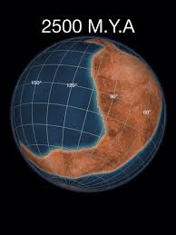
Kenorland
Kenorland is a hypothetical Neoarchean supercontinent. If it existed, it would have been one of the earliest known supercontinents on Earth. It is thought to have formed during the Neoarchaean Era c. 2.72 billion years ago (2.72 Ga) by the accretion of Neoarchaean cratons and the formation of new continental crust. It comprised what later became Laurentia (the core of today's North America and Greenland), Baltica (today's Scandinavia and Baltic), Western Australia and Kalaharia.
Swarms of volcanic dikes and their paleomagnetic orientation as well as the existence of similar stratigraphic sequences permit this reconstruction. The core of Kenorland, the Baltic/Fennoscandian Shield, traces its origins back to over 3.1 Ga. The Yilgarn craton (present-day Western Australia) contains zircon crystals in its crust that date back to 4.4 Ga.
Kenorland was named after the Kenoran orogeny (also called the Algoman orogeny), which in turn was named after the town of Kenora, Ontario.
Kenorland was formed around 2.72 billion years ago (2.72 Ga) as a result of a series of accretion events and the formation of new continental crust.
The accretion events are recorded in the greenstone belts of the Yilgarn craton as metamorphosed basalt belts and granitic domes accreted around the high grade metamorphic core of the Western Gneiss terrane, which includes elements of up to 3.2 Ga in age and some older portions, for example the Narryer Gneiss terrane.
Paleomagnetic studies show Kenorland was in generally low latitudes until tectonic magma-plume rifting began to occur between 2.48 Ga and 2.45 Ga. At 2.45 Ga the Baltic Shield was over the equator and was joined to Laurentia (the Canadian Shield) and both the Kola and Karelia cratons. The protracted breakup of Kenorland during the Late Neoarchaean and early Paleoproterozoic Era 2.48 to 2.10 Gya, during the Siderian and Rhyacian periods, is manifested by mafic dikes and sedimentary rift-basins and rift-margins on many continents. On early Earth, this type of bimodal deep mantle plume rifting was common in Archaean and Neoarchaean crust and continent formation.
The geological time period surrounding the breakup of Kenorland is thought by many geologists to be the beginning of the transition point from the deep-mantle-plume method of continent formation in the Hadean to Early Archean (before the final formation of the Earth's inner core) to the subsequent two-layer core-mantle plate tectonics convection theory. However, the findings of an earlier continent, Ur, and a supercontinent of around 3.1 Gya, Vaalbara, indicate this transition period may have occurred much earlier.
The Kola and Karelia cratons began to drift apart around 2.45 Gya, and by 2.4 Gya the Kola craton was at about 30 degrees south latitude and the Karelia craton was at about 15 degrees south latitude. Paleomagnetic evidence shows that at 2.45 Gya the Yilgarn craton (now the bulk of Western Australia) was not connected to Fennoscandia-Laurentia and was at about ~5 degrees south latitude.[citation needed]
Recent media
Recent media