
Community hub
Recent from talks
Contribute something to knowledge base
Content stats: 0 posts, 0 articles, 1 media, 0 notes
Members stats: 0 subscribers, 0 contributors, 0 moderators, 0 supporters
Subscribers
Supporters
Contributors
Moderators
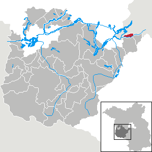
Kleinmachnow
Kleinmachnow (German pronunciation: [klaɪnˈmaxno] ⓘ) is a municipality in the Potsdam-Mittelmark district, in Brandenburg, Germany. It is situated south-west of the borough of Steglitz-Zehlendorf and east of Potsdam.
First mentioned in the Landbuch of Karl IV in 1375, the Kleinmachnow played an important role at the Bäke beek / creek crossing, secured by multiple medieval castles. The last of these castles (none of which are preserved today) belonged to the Knights of Hake, a family who shaped the local history until the 20th century. The replacement of the Bäke (beek / creek) with the Teltow Canal in 1906 brought the village the now listed historic Kleinmachnow flood-gate.
In the first half of the 20th century, Kleinmachnow grew from a rural village to a suburban municipality of the Berlin metropolitan area. The construction of the Berlin Wall cut Kleinmachnow off from West Berlin. The community's location near the border meant it was relatively isolated in the GDR. Since the German reunification, Kleinmachnow has been part of the growth of the countryside areas outside of Berlin.
Kleinmachnow is bordered by the Teltow Canal in the south and by the city boundary of Berlin in the north, west and east, forming a kind of indentation in the district of Steglitz-Zehlendorf, which is a neighbouring borough. The municipality encompasses the settlement of Dreilinden.
During the Cold War period, the area could only be accessed from Teltow and Stahnsdorf via three bridges across the Teltow Canal, and access from Berlin-Zehlendorf was once again granted after 1990. Since 1996, Kleinmachnow has a separate motorway connection to the German federal motorway 115 in the west. The centre of Berlin is situated 19 km (12 mi) north-east of the town, and Potsdam 12 km (7.5 mi) east of the town.
Located in the southwestern part of Berlin and adjacent Brandenburg, Kleinmachnow sits on the Teltow Ground Moraine Plateau, carved into a turbulent relief of small-scale chains of hills formed from boulder clay and meltwater channels, interspersed with puddles and pools. Geologically, the youngest Vistula Ice Age, about 21,000 years ago, created a loose erosion in the Bäke Valley that made the construction of the Teltow Canal between the Seeberg and Weinberg possible. The Seeberg area, at 65 meters above sea level, is the highest elevation in the region.
The Buschgraben is a glacial meltwater channel, located on the southwest border of Berlin, stretching in a north–south direction between the localities of Berlin-Zehlendorf and Kleinmachnow, ending at the Teltowkanal northwest of Teltow. The region of Kleinmachnow contains several small bodies of water, formed from dead ice holes. The Meiereipfuhl in the Bannwald formerly held five ponds, this has since reduced with the Duellpfuhl an der Ginsterheide, Pferdepfuhl, and Pfuhl am Jägerstieg/Ecke Wolfswerder serving as receptacles for roadway surface water today.
Kleinmachnow arose at the former Bäke creek, today replaced by the Teltow Canal built in 1906. Parvo Machenow was first mentioned in the 1375 land registry (Landbuch) of Emperor Charles IV, then also Brandenburg Elector. In medieval times the ford was controlled by a castle, recently held by the Hake noble family. Together with the canal the Kleinmachnow lock was erected, soon becoming a landmark.
Recent media
Recent media