

Community hub
0 subscribers8 pages, 0 posts
Recent from talks
All channels
Be the first to start a discussion here.
Be the first to start a discussion here.
Be the first to start a discussion here.
Be the first to start a discussion here.
Contribute something
Welcome to the community hub built to collect knowledge and have discussions related to Kniebrink.
Nothing was collected or created yet.
Kniebrink
View on Wikipediafrom Wikipedia
The Kniebrink, at 315 m above sea level (NN), is the third highest mountain in the northern German Wiehen Hills. Its immediate summit belongs administratively to the village of Oberbauerschaft in the municipality of Hüllhorst. However, its boundary with the town of Lübbecke runs just north of the summit, so that its northern slopes belong to Lübbecke.
Key Information


The Kniebrink is just 3 metres lower than the more northerly Wurzelbrink, which obscures it from view in Lübbecke. The hill is largely trackless. In spring 2007 its trees suffered major storm damage. The top can be reaches from Lübbecke in under 45 minutes. From the south you need about 20 minutes for the short but steep climb.
Gallery
[edit]-
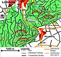 The Kniebrink lies immediately south of the Wurzelbrink
 -
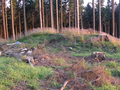 On the treeless summit region, this hillock, the actual peak, is easy to make out
 -
 On the summit area, deforested by the storm, there are now clumps of foxglove
 -
 This path leads to the top
 -
 Like the neighbouring Wurzelbrink, the Kniebrink is also over 300m high


External links
[edit] Media related to Kniebrink at Wikimedia Commons