Recent from talks
Lake Eyre basin
Knowledge base stats:
Talk channels stats:
Members stats:
Lake Eyre basin
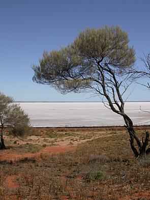
The Lake Eyre basin (/ɛər/ AIR) is a drainage basin that covers just under one-sixth of all Australia. It is the largest endorheic basin in Australia and amongst the largest in the world, covering about 1,200,000 square kilometres (463,323 sq mi), including much of inland Queensland, large portions of South Australia and the Northern Territory, and a part of western New South Wales. The basin is also one of the largest, least-developed arid-zone basins with a high degree of variability anywhere. It supports only about 60,000 people and has no major irrigation, diversions, or flood-plain developments. Low-density grazing that sustains a large amount of wildlife is the major land use, occupying 82% of the total land within the basin. The Lake Eyre basin of precipitation (rain water) to a great extent geographically overlaps the Great Artesian Basin underneath.
The basin began as a sinking landmass mostly covered by forest and contained many more lakes than now. The climate has changed from wet to arid over the last 60 million years. Most of the rivers in the Lake Eyre basin are now slow flowing, flat, and completely dry for lengthy periods. When the country north of the basin floods, floodwaters drain via the main rivers of the basin—Cooper Creek, Georgina River, and Diamantina River—southwards towards Kati Thanda–Lake Eyre, the country's lowest point at 16 metres (52 ft) below sea level. The water overflows the river banks, across the floodplains, filling waterholes and wetlands and carving new channels, giving rise to the name Channel Country. Most of the rain which falls in the north never reaches the lake 1,000 km away, which only fills occasionally.
Management of the area has been problematic as it is covered by four different states' jurisdictions. As the ecological significance of the basin has become known and mismanagement of another Australian basin, the Murray-Darling Basin, became apparent during several drought cycles, it became clear that ongoing management issues had to be resolved. In 2001 the Lake Eyre Basin Intergovernmental Agreement was signed, which was set up to ensure the sustainability of the Lake Eyre Basin river systems.
In 2014, the Queensland Government changed the laws protecting the rivers and floodplains. As of 2022[update] there are fears that mining for coal seam gas could be very detrimental to the fragile environment of the floodplains.
The basin began to form in the early Paleogene (about 60 million years ago) when south-eastern South Australia started to sink and rivers began to deposit sediment into the large, shallow basin. A remnant of an old oceanic plate is currently sinking in the mantle beneath the basin. The suction effect of this sinking likely caused both the Lake Eyre Basin as well as the Murray-Darling basin to form. The basin is still gradually sinking, and still gradually accumulating sediment. For many millions of years, the Lake Eyre Basin was well-supplied with water and largely forested. About 20 million years ago, large, shallow lakes formed, covering much of the area for about 10 million years. From that time on, as Australia drifted further north and the climate became gradually more arid, the lakes and floodplains started to dry. Only in the last 2.6 million years did the onset of the ice ages bring about the present climatic regime and the consequent fairly rapid desertification of the area.
The basin covers just under one-sixth of all Australia and is the largest endorheic basin in Australia and amongst the largest in the world, covering about 1,200,000 square kilometres (463,323 sq mi), including much of inland Queensland, large portions of South Australia and the Northern Territory, and a part of western New South Wales.
During years of especially high rainfall, all the riverbeds in this vast, mostly flat, arid and semi-arid area lead inland (not towards the sea) towards Lake Eyre in central South Australia.
Lake Eyre itself lies approximately 16 metres (52 ft) below sea level, and usually contains only salt. In flood years, it fills and, for a short time, undergoes a period of rapid growth and fertility: long-dormant marine creatures multiply and large flocks of waterfowl arrive to feed and raise their young before the waters evaporate once more. The annual mean runoff in the Lake Eyre Basin is the lowest of any of the world's major drainage basins.
Hub AI
Lake Eyre basin AI simulator
(@Lake Eyre basin_simulator)
Lake Eyre basin
The Lake Eyre basin (/ɛər/ AIR) is a drainage basin that covers just under one-sixth of all Australia. It is the largest endorheic basin in Australia and amongst the largest in the world, covering about 1,200,000 square kilometres (463,323 sq mi), including much of inland Queensland, large portions of South Australia and the Northern Territory, and a part of western New South Wales. The basin is also one of the largest, least-developed arid-zone basins with a high degree of variability anywhere. It supports only about 60,000 people and has no major irrigation, diversions, or flood-plain developments. Low-density grazing that sustains a large amount of wildlife is the major land use, occupying 82% of the total land within the basin. The Lake Eyre basin of precipitation (rain water) to a great extent geographically overlaps the Great Artesian Basin underneath.
The basin began as a sinking landmass mostly covered by forest and contained many more lakes than now. The climate has changed from wet to arid over the last 60 million years. Most of the rivers in the Lake Eyre basin are now slow flowing, flat, and completely dry for lengthy periods. When the country north of the basin floods, floodwaters drain via the main rivers of the basin—Cooper Creek, Georgina River, and Diamantina River—southwards towards Kati Thanda–Lake Eyre, the country's lowest point at 16 metres (52 ft) below sea level. The water overflows the river banks, across the floodplains, filling waterholes and wetlands and carving new channels, giving rise to the name Channel Country. Most of the rain which falls in the north never reaches the lake 1,000 km away, which only fills occasionally.
Management of the area has been problematic as it is covered by four different states' jurisdictions. As the ecological significance of the basin has become known and mismanagement of another Australian basin, the Murray-Darling Basin, became apparent during several drought cycles, it became clear that ongoing management issues had to be resolved. In 2001 the Lake Eyre Basin Intergovernmental Agreement was signed, which was set up to ensure the sustainability of the Lake Eyre Basin river systems.
In 2014, the Queensland Government changed the laws protecting the rivers and floodplains. As of 2022[update] there are fears that mining for coal seam gas could be very detrimental to the fragile environment of the floodplains.
The basin began to form in the early Paleogene (about 60 million years ago) when south-eastern South Australia started to sink and rivers began to deposit sediment into the large, shallow basin. A remnant of an old oceanic plate is currently sinking in the mantle beneath the basin. The suction effect of this sinking likely caused both the Lake Eyre Basin as well as the Murray-Darling basin to form. The basin is still gradually sinking, and still gradually accumulating sediment. For many millions of years, the Lake Eyre Basin was well-supplied with water and largely forested. About 20 million years ago, large, shallow lakes formed, covering much of the area for about 10 million years. From that time on, as Australia drifted further north and the climate became gradually more arid, the lakes and floodplains started to dry. Only in the last 2.6 million years did the onset of the ice ages bring about the present climatic regime and the consequent fairly rapid desertification of the area.
The basin covers just under one-sixth of all Australia and is the largest endorheic basin in Australia and amongst the largest in the world, covering about 1,200,000 square kilometres (463,323 sq mi), including much of inland Queensland, large portions of South Australia and the Northern Territory, and a part of western New South Wales.
During years of especially high rainfall, all the riverbeds in this vast, mostly flat, arid and semi-arid area lead inland (not towards the sea) towards Lake Eyre in central South Australia.
Lake Eyre itself lies approximately 16 metres (52 ft) below sea level, and usually contains only salt. In flood years, it fills and, for a short time, undergoes a period of rapid growth and fertility: long-dormant marine creatures multiply and large flocks of waterfowl arrive to feed and raise their young before the waters evaporate once more. The annual mean runoff in the Lake Eyre Basin is the lowest of any of the world's major drainage basins.
Recent media