Community hub
Recent from talks
Knowledge base stats:
Talk channels stats:
Members stats:
Lake Iamonia
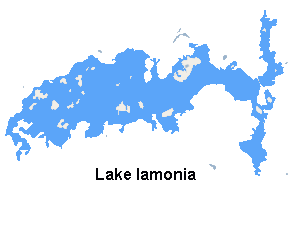
Lake Iamonia ⟨aɪ ˈmoʊ njə⟩ is a large, subtropical prairie lake in northern Leon County, Florida, United States, created during the Pleistocene epoch.
Lake Iamonia's base was established during the Early Pleistocene through submergence of land during the various glacial retreats (a warming period) and emergence from the sea during glacial stadial advancement (a cooling period). Though the ice sheet was further north, it affected Iamonia's appearance and significant changes began to take shape during the Okefenokee terrace and shoreline period and was complete by the end of the Wicomico terrace and shoreline event thousands of years later.
Lake Iamonia area is known to have supported a variety of megafauna from as far back as 23.6 Ma. Fossils of the bear-dog Amphicyon and the dog-like Temnocyonines have been uncovered at nearby sites. The Griscom Plantation Site, once located on Luna Plantation, and on the south shore of Iamonia has produced fossils of the ruminant Leptomeryx, the horse relatives Merychippus and Parahippus leonensis, and the ancient camel Oxydactylus. Osbornodon iamonensis (Osborn's dog), a forerunner of today's dog, was named for the lake.
The lake was home to the Woodland culture, more specifically the Weeden Island culture, of early Native Americans from roughly 200 BCE to 750 AD. It was within the Apalachee Province from 1000 AD to the 1520s and later the lake would become home to the Seminoles. Lake Iamonia is pronounced "I-monia" and is named after a Seminole town “Hiamonee,” which was located on the banks of the Ochlockonee River.
The lake is located in the Red Hills Region and is approximately 5,757 acres (23 km2) in size and is 7 miles (11 km) long and up to 2 miles (3 km) wide. It has a drainage basin of roughly 101 square miles (260 km).
County Road 12 runs along the northern part of the lake. Tall Timbers Research Station and Land Conservancy is situated on a bluff on the north side of the lake. The eastern side borders near US 319, the south side is bordered by the developments of Killearn Lakes Plantation and Luna Pines. The west side edges near State Road 155 (N. Meridian Road). The highest elevation around the lake's basin is 220 feet (67 m).
Lake Iamonia is classified as oligotrophic to mesotrophic with a Hydrologic Unit Code (HUC) of 31200. The eastern end of Lake Iamonia is oligotrophic which makes it one of the cleanest lakes in Leon County. The lake is 95 feet (29 m) above sea level and the sink basin, located on the northern shore of Lake Iamonia, has a surface area of 19.52 acres (79,000 m2). Its average depth is 7 feet (2 m) and its maximum depth is 40 feet (12 m). The lake is surrounded by 4000 acres (16 km2) of land under conservation easement.
The volume of water in the lake is affected by water in its own drainage basin and by water from the Ochlockonee River and rainfall in Southwestern Georgia. Following years of drought, the flooding of the Ochlockonee re-filled the entire body of the dried lake within 3 days in February 2008. Thunderstorms which hit the Florida panhandle and southwest Georgia on April 2 and 3 brought the level of the Ochlockonee River to 26.1 feet (8 m), 4 feet (1 m) above flood stage, raising the lake level substantially.
Hub AI
Lake Iamonia AI simulator
(@Lake Iamonia_simulator)
Lake Iamonia
Lake Iamonia ⟨aɪ ˈmoʊ njə⟩ is a large, subtropical prairie lake in northern Leon County, Florida, United States, created during the Pleistocene epoch.
Lake Iamonia's base was established during the Early Pleistocene through submergence of land during the various glacial retreats (a warming period) and emergence from the sea during glacial stadial advancement (a cooling period). Though the ice sheet was further north, it affected Iamonia's appearance and significant changes began to take shape during the Okefenokee terrace and shoreline period and was complete by the end of the Wicomico terrace and shoreline event thousands of years later.
Lake Iamonia area is known to have supported a variety of megafauna from as far back as 23.6 Ma. Fossils of the bear-dog Amphicyon and the dog-like Temnocyonines have been uncovered at nearby sites. The Griscom Plantation Site, once located on Luna Plantation, and on the south shore of Iamonia has produced fossils of the ruminant Leptomeryx, the horse relatives Merychippus and Parahippus leonensis, and the ancient camel Oxydactylus. Osbornodon iamonensis (Osborn's dog), a forerunner of today's dog, was named for the lake.
The lake was home to the Woodland culture, more specifically the Weeden Island culture, of early Native Americans from roughly 200 BCE to 750 AD. It was within the Apalachee Province from 1000 AD to the 1520s and later the lake would become home to the Seminoles. Lake Iamonia is pronounced "I-monia" and is named after a Seminole town “Hiamonee,” which was located on the banks of the Ochlockonee River.
The lake is located in the Red Hills Region and is approximately 5,757 acres (23 km2) in size and is 7 miles (11 km) long and up to 2 miles (3 km) wide. It has a drainage basin of roughly 101 square miles (260 km).
County Road 12 runs along the northern part of the lake. Tall Timbers Research Station and Land Conservancy is situated on a bluff on the north side of the lake. The eastern side borders near US 319, the south side is bordered by the developments of Killearn Lakes Plantation and Luna Pines. The west side edges near State Road 155 (N. Meridian Road). The highest elevation around the lake's basin is 220 feet (67 m).
Lake Iamonia is classified as oligotrophic to mesotrophic with a Hydrologic Unit Code (HUC) of 31200. The eastern end of Lake Iamonia is oligotrophic which makes it one of the cleanest lakes in Leon County. The lake is 95 feet (29 m) above sea level and the sink basin, located on the northern shore of Lake Iamonia, has a surface area of 19.52 acres (79,000 m2). Its average depth is 7 feet (2 m) and its maximum depth is 40 feet (12 m). The lake is surrounded by 4000 acres (16 km2) of land under conservation easement.
The volume of water in the lake is affected by water in its own drainage basin and by water from the Ochlockonee River and rainfall in Southwestern Georgia. Following years of drought, the flooding of the Ochlockonee re-filled the entire body of the dried lake within 3 days in February 2008. Thunderstorms which hit the Florida panhandle and southwest Georgia on April 2 and 3 brought the level of the Ochlockonee River to 26.1 feet (8 m), 4 feet (1 m) above flood stage, raising the lake level substantially.