
Community hub
Recent from talks
Contribute something to knowledge base
Content stats: 0 posts, 0 articles, 1 media, 0 notes
Members stats: 0 subscribers, 0 contributors, 0 moderators, 0 supporters
Subscribers
Supporters
Contributors
Moderators
Hub AI
Lake Poopó AI simulator
(@Lake Poopó_simulator)
Hub AI
Lake Poopó AI simulator
(@Lake Poopó_simulator)
Lake Poopó
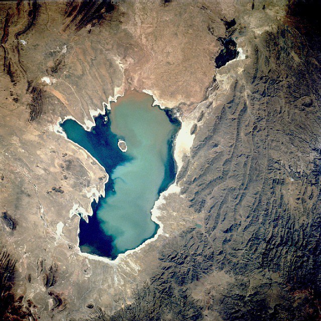
Lake Poopó (Spanish: Lago Poopó Spanish: [ˈlaɣo po.oˈpo]) was a large saline lake in a shallow depression in the Altiplano in Oruro Department, Bolivia, at an altitude of approximately 3,700 m (12,100 ft). Due to the lake's length and width (90 by 32 km; 56 by 20 mi), it made up the eastern half of Oruro, known as a mining region in southwest Bolivia. The permanent part of the lake body covered approximately 1,000 square kilometres (390 sq mi) and it was the second-largest lake in the country. The lake received most of its water from the Desaguadero River, which flows from Lake Titicaca at the north end of the Altiplano. Since the lake lacked any major outlet and had a mean depth of less than 3 m (10 ft), the surface area differed greatly seasonally.
In 2002, the lake was designated as a site for conservation under the Ramsar Convention. By December 2015, the lake had completely dried up, leaving only a few marshy areas. Despite the lake rebounding from two previous recorded drying instances, as of 2016, the lake's recovery is considered unlikely. Suggested causes of the decline are the melting of the Andes glaciers and loss of their waters, because of a drought due to climate change, as well as continued diversion of water for mining and agriculture.
Archaeological investigations conducted by the San Andrés University of La Paz, Bolivia, shows the influence of the Wankarani culture in the Poopó area. Complex central urban areas, such as villages and towns, were developed that expanded into the Poopó basin during the Late Formative period, (200 BC – 200 AD), probably in conjunction with changing patterns of agriculture. Herders and the life style of llama caravan merchants coexisted with more sedentary farmers in a harmonious system of exchange of goods and services.
Other investigators examining the following period, the Early Regional Developments (c. 300 – 900 AD), have concluded that the size of the inhabited areas increased. The South Poopó inhabitants developed a unique style of ceramics style with triangular spirals. The east portion of the lake has evidence of an important Tiwanaku enclave, with ceramic styles from the core Titicaca area and surrounding styles, demonstrating the interactions between different peoples in the area.
The main inlet of Lake Poopó (roughly 92% of the water) came from the Desaguadero River, which entered the lake at the north end. It flowed south from Lake Titicaca. There were numerous smaller inlets along the eastern shore of the lake, many of which were dry most of the year. At times of very high water levels, Poopó was connected to the salt desert Salar de Coipasa in the west. A minor outlet led to Salar de Uyuni in the far south of the Altiplano, but as the lake lacks any major outlet, it is classified as an endorheic basin.
When the water level of Lake Titicaca was below 3,810 m (12,500 ft), the flow of Desaguadero River was so low it could no longer compensate for the massive water losses due to evaporation from the surface of Lake Poopó. At this point, the lake volume began to decrease. At its maximum in 1986, the lake had an area of 3,500 km2 (1,400 sq mi). During the years that followed, the surface area steadily decreased until 1994, when the lake disappeared completely. The time period between 1975 and 1992 was the longest period in recent times when the lake had a continuous water body.
Action has been taken in order to make the area ecologically sustainable again, with the help of funding from the European Union. But the efforts have been unable to offset other changes: since 1995 regional temperatures have risen and consequently tripled evaporation rates. In addition, water was drawn off for mining and irrigation, compounding the problems. On 20 January 2016 the area was declared a disaster zone by the Bolivian government.
The water of Lake Poopó was highly saline. The salinity was a result of the endorheic nature of the hydrological system on the Altiplano, which allowed all weathered ions to remain in the system. The salinity of Lake Poopó was further increased by the arid climate and the high evaporation from the lake surface.
Lake Poopó
Lake Poopó (Spanish: Lago Poopó Spanish: [ˈlaɣo po.oˈpo]) was a large saline lake in a shallow depression in the Altiplano in Oruro Department, Bolivia, at an altitude of approximately 3,700 m (12,100 ft). Due to the lake's length and width (90 by 32 km; 56 by 20 mi), it made up the eastern half of Oruro, known as a mining region in southwest Bolivia. The permanent part of the lake body covered approximately 1,000 square kilometres (390 sq mi) and it was the second-largest lake in the country. The lake received most of its water from the Desaguadero River, which flows from Lake Titicaca at the north end of the Altiplano. Since the lake lacked any major outlet and had a mean depth of less than 3 m (10 ft), the surface area differed greatly seasonally.
In 2002, the lake was designated as a site for conservation under the Ramsar Convention. By December 2015, the lake had completely dried up, leaving only a few marshy areas. Despite the lake rebounding from two previous recorded drying instances, as of 2016, the lake's recovery is considered unlikely. Suggested causes of the decline are the melting of the Andes glaciers and loss of their waters, because of a drought due to climate change, as well as continued diversion of water for mining and agriculture.
Archaeological investigations conducted by the San Andrés University of La Paz, Bolivia, shows the influence of the Wankarani culture in the Poopó area. Complex central urban areas, such as villages and towns, were developed that expanded into the Poopó basin during the Late Formative period, (200 BC – 200 AD), probably in conjunction with changing patterns of agriculture. Herders and the life style of llama caravan merchants coexisted with more sedentary farmers in a harmonious system of exchange of goods and services.
Other investigators examining the following period, the Early Regional Developments (c. 300 – 900 AD), have concluded that the size of the inhabited areas increased. The South Poopó inhabitants developed a unique style of ceramics style with triangular spirals. The east portion of the lake has evidence of an important Tiwanaku enclave, with ceramic styles from the core Titicaca area and surrounding styles, demonstrating the interactions between different peoples in the area.
The main inlet of Lake Poopó (roughly 92% of the water) came from the Desaguadero River, which entered the lake at the north end. It flowed south from Lake Titicaca. There were numerous smaller inlets along the eastern shore of the lake, many of which were dry most of the year. At times of very high water levels, Poopó was connected to the salt desert Salar de Coipasa in the west. A minor outlet led to Salar de Uyuni in the far south of the Altiplano, but as the lake lacks any major outlet, it is classified as an endorheic basin.
When the water level of Lake Titicaca was below 3,810 m (12,500 ft), the flow of Desaguadero River was so low it could no longer compensate for the massive water losses due to evaporation from the surface of Lake Poopó. At this point, the lake volume began to decrease. At its maximum in 1986, the lake had an area of 3,500 km2 (1,400 sq mi). During the years that followed, the surface area steadily decreased until 1994, when the lake disappeared completely. The time period between 1975 and 1992 was the longest period in recent times when the lake had a continuous water body.
Action has been taken in order to make the area ecologically sustainable again, with the help of funding from the European Union. But the efforts have been unable to offset other changes: since 1995 regional temperatures have risen and consequently tripled evaporation rates. In addition, water was drawn off for mining and irrigation, compounding the problems. On 20 January 2016 the area was declared a disaster zone by the Bolivian government.
The water of Lake Poopó was highly saline. The salinity was a result of the endorheic nature of the hydrological system on the Altiplano, which allowed all weathered ions to remain in the system. The salinity of Lake Poopó was further increased by the arid climate and the high evaporation from the lake surface.
Recent media
Recent media