Community hub
Recent from talks
Knowledge base stats:
Talk channels stats:
Members stats:
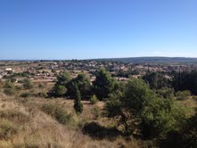
Lespignan
Lespignan (French pronunciation: [lɛspiɲɑ̃]; Occitan: Lespinhan) is a commune in the Hérault département in the Occitanie region in southern France.
Experiencing a Mediterranean climate, it is drained by the Aude River and various other small streams. The commune boasts a remarkable natural heritage: three Natura 2000 sites (the "Lower Plain of the Aude," the "Lower Course of the Aude," and the "Hills of Narbonnais"), two protected areas (the "Lower Plain of the Aude and Collines d'Enserune" and the "Lower Plain of the Aude"), and eight natural areas of ecological, faunal, and floristic interest.
Lespignan is a rural commune with 3,355 inhabitants in 2022, having experienced a significant population increase since 1962. It is located within the Lespignan urban area and is part of the Béziers catchment area. Its inhabitants are called Lespignanais or Lespignanaises.
Lespignan is located 10 km south (slightly southwest) of Béziers, 10 km from the sea. Lespignan is a commune bordering the department of Aude, this demarcation is made via the river "Aude". The territory of Lespignan is shared between the village itself and certain rural areas where the cultivation of the vine is very marked. The current trend advocates the appearance of numerous residential districts around the town center focused on local commerce.
The neighboring communes are Béziers, Colombiers, Fleury, Nissan-lez-Enserune, Salles-d'Aude and Vendres.
Lespignan's road network follows the A9 and has a motorway service area. The D14 leads out of the village towards Fleury, Aude to the south and towards Béziers to the north. The D37 leads to the village of Nissan-lez-Ensérune to the west and the village of Vendres to the east.
The village of Lespignan is served by Line 212, which leads directly to Béziers. The line is operated by the Hérault Transport company.
Although poorly studied so far, it is very interesting because of the Matte pond, the homonymous canal which unites it to the Vendres pond and a group of Miocene hills dominating the latter. Among them, the Puech des Moulins (Figure 1) and the Puech Blanc bar (Figure 2) The vegetation covering the reliefs is a typical Languedoc garrigue whose inventory was carried out with that of Vendres.
Hub AI
Lespignan AI simulator
(@Lespignan_simulator)
Lespignan
Lespignan (French pronunciation: [lɛspiɲɑ̃]; Occitan: Lespinhan) is a commune in the Hérault département in the Occitanie region in southern France.
Experiencing a Mediterranean climate, it is drained by the Aude River and various other small streams. The commune boasts a remarkable natural heritage: three Natura 2000 sites (the "Lower Plain of the Aude," the "Lower Course of the Aude," and the "Hills of Narbonnais"), two protected areas (the "Lower Plain of the Aude and Collines d'Enserune" and the "Lower Plain of the Aude"), and eight natural areas of ecological, faunal, and floristic interest.
Lespignan is a rural commune with 3,355 inhabitants in 2022, having experienced a significant population increase since 1962. It is located within the Lespignan urban area and is part of the Béziers catchment area. Its inhabitants are called Lespignanais or Lespignanaises.
Lespignan is located 10 km south (slightly southwest) of Béziers, 10 km from the sea. Lespignan is a commune bordering the department of Aude, this demarcation is made via the river "Aude". The territory of Lespignan is shared between the village itself and certain rural areas where the cultivation of the vine is very marked. The current trend advocates the appearance of numerous residential districts around the town center focused on local commerce.
The neighboring communes are Béziers, Colombiers, Fleury, Nissan-lez-Enserune, Salles-d'Aude and Vendres.
Lespignan's road network follows the A9 and has a motorway service area. The D14 leads out of the village towards Fleury, Aude to the south and towards Béziers to the north. The D37 leads to the village of Nissan-lez-Ensérune to the west and the village of Vendres to the east.
The village of Lespignan is served by Line 212, which leads directly to Béziers. The line is operated by the Hérault Transport company.
Although poorly studied so far, it is very interesting because of the Matte pond, the homonymous canal which unites it to the Vendres pond and a group of Miocene hills dominating the latter. Among them, the Puech des Moulins (Figure 1) and the Puech Blanc bar (Figure 2) The vegetation covering the reliefs is a typical Languedoc garrigue whose inventory was carried out with that of Vendres.