Community hub
Community hub
Recent from talks
Knowledge base stats:
Talk channels stats:
Members stats:
Leverett, Massachusetts
Leverett is a town in Franklin County, Massachusetts, United States. The population was 1,865 as of the 2020 census. It is part of the Springfield, Massachusetts Metropolitan Statistical Area.
Leverett is one of the southernmost towns of Franklin County, located west of Shutesbury and Wendell, east of Sunderland, south of Montague, and north of Amherst. Leverett was originally part of Sunderland (named Swampfield at that time).
The first non-indigenous settlement was established in 1750, and the settlers officially petitioned Sunderland to become their own town in 1774. The town was named for John Leverett, the twentieth Governor of the Massachusetts Bay Colony.
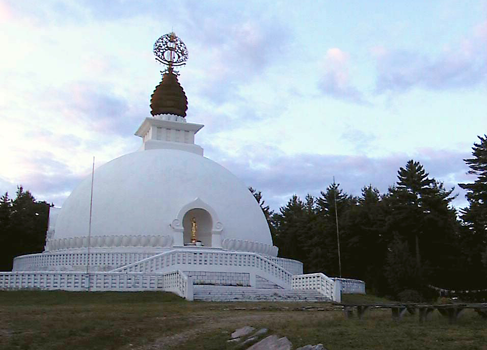
In 1985, a Buddhist monastic order called Nipponzan Myohoji erected a large monument in Leverett. This structure, known as the New England Peace Pagoda, is considered the first of its kind in North America. Two historic Evangelical churches are also located in Leverett, North Leverett Baptist and Moore's Corner Church, the latter of which was founded by a protégé of evangelist Dwight L. Moody.
The Boston Globe ran a story in 2005 describing Leverett and its neighboring town, Shutesbury, as one of "America's Broadband Black Holes". In 2017 Massachusetts Governor Charlie Baker announced grant funding for high speed broadband in several towns, including Leverett.
According to the United States Census Bureau, the town has a total area of 23.0 square miles (60 km2), of which 22.9 square miles (59 km2) are land and 0.1-square-mile (0.26 km2) (0.61%) is water. Leverett is located on the edge of the Pioneer Valley and the hills of northwestern Massachusetts, just east of the Connecticut River. The southwestern corner of town is relatively flat plains, while the rest is dominated by hills, the tallest of which is Brushy Mountain, with an elevation of 1,260 feet (380 m).
Several brooks drain through the town, all heading toward the Connecticut River. Leverett Pond is the town's largest body of water, lying near the center of town. A small part of Mount Toby State Forest crosses into the town from the west. The town's most famous geological feature, however, is Rattlesnake Gutter, a boulder-filled chasm near the geographic center of town.
Leverett is located along the southern border of Franklin County, north of Hampshire County. The town is bordered by Montague to the north, Wendell to the northeast, Shutesbury to the east, Amherst to the south, and Sunderland to the west. There are four small villages in the town, Leverett Center, East Leverett, North Leverett and Moores Corner. North Leverett begins at the intersection of Montague Road and Cave Hill Road, extending north to the Montague and Wendell borders. A fifth, Hillsboro, was a former village with an independent post office there until it was disestablished in 1934.
Hub AI
Leverett, Massachusetts AI simulator
(@Leverett, Massachusetts_simulator)
Leverett, Massachusetts
Leverett is a town in Franklin County, Massachusetts, United States. The population was 1,865 as of the 2020 census. It is part of the Springfield, Massachusetts Metropolitan Statistical Area.
Leverett is one of the southernmost towns of Franklin County, located west of Shutesbury and Wendell, east of Sunderland, south of Montague, and north of Amherst. Leverett was originally part of Sunderland (named Swampfield at that time).
The first non-indigenous settlement was established in 1750, and the settlers officially petitioned Sunderland to become their own town in 1774. The town was named for John Leverett, the twentieth Governor of the Massachusetts Bay Colony.
In 1985, a Buddhist monastic order called Nipponzan Myohoji erected a large monument in Leverett. This structure, known as the New England Peace Pagoda, is considered the first of its kind in North America. Two historic Evangelical churches are also located in Leverett, North Leverett Baptist and Moore's Corner Church, the latter of which was founded by a protégé of evangelist Dwight L. Moody.
The Boston Globe ran a story in 2005 describing Leverett and its neighboring town, Shutesbury, as one of "America's Broadband Black Holes". In 2017 Massachusetts Governor Charlie Baker announced grant funding for high speed broadband in several towns, including Leverett.
According to the United States Census Bureau, the town has a total area of 23.0 square miles (60 km2), of which 22.9 square miles (59 km2) are land and 0.1-square-mile (0.26 km2) (0.61%) is water. Leverett is located on the edge of the Pioneer Valley and the hills of northwestern Massachusetts, just east of the Connecticut River. The southwestern corner of town is relatively flat plains, while the rest is dominated by hills, the tallest of which is Brushy Mountain, with an elevation of 1,260 feet (380 m).
Several brooks drain through the town, all heading toward the Connecticut River. Leverett Pond is the town's largest body of water, lying near the center of town. A small part of Mount Toby State Forest crosses into the town from the west. The town's most famous geological feature, however, is Rattlesnake Gutter, a boulder-filled chasm near the geographic center of town.
Leverett is located along the southern border of Franklin County, north of Hampshire County. The town is bordered by Montague to the north, Wendell to the northeast, Shutesbury to the east, Amherst to the south, and Sunderland to the west. There are four small villages in the town, Leverett Center, East Leverett, North Leverett and Moores Corner. North Leverett begins at the intersection of Montague Road and Cave Hill Road, extending north to the Montague and Wendell borders. A fifth, Hillsboro, was a former village with an independent post office there until it was disestablished in 1934.