



Community hub
Recent from talks
Knowledge base stats:
Talk channels stats:
Members stats:
Limpopo River
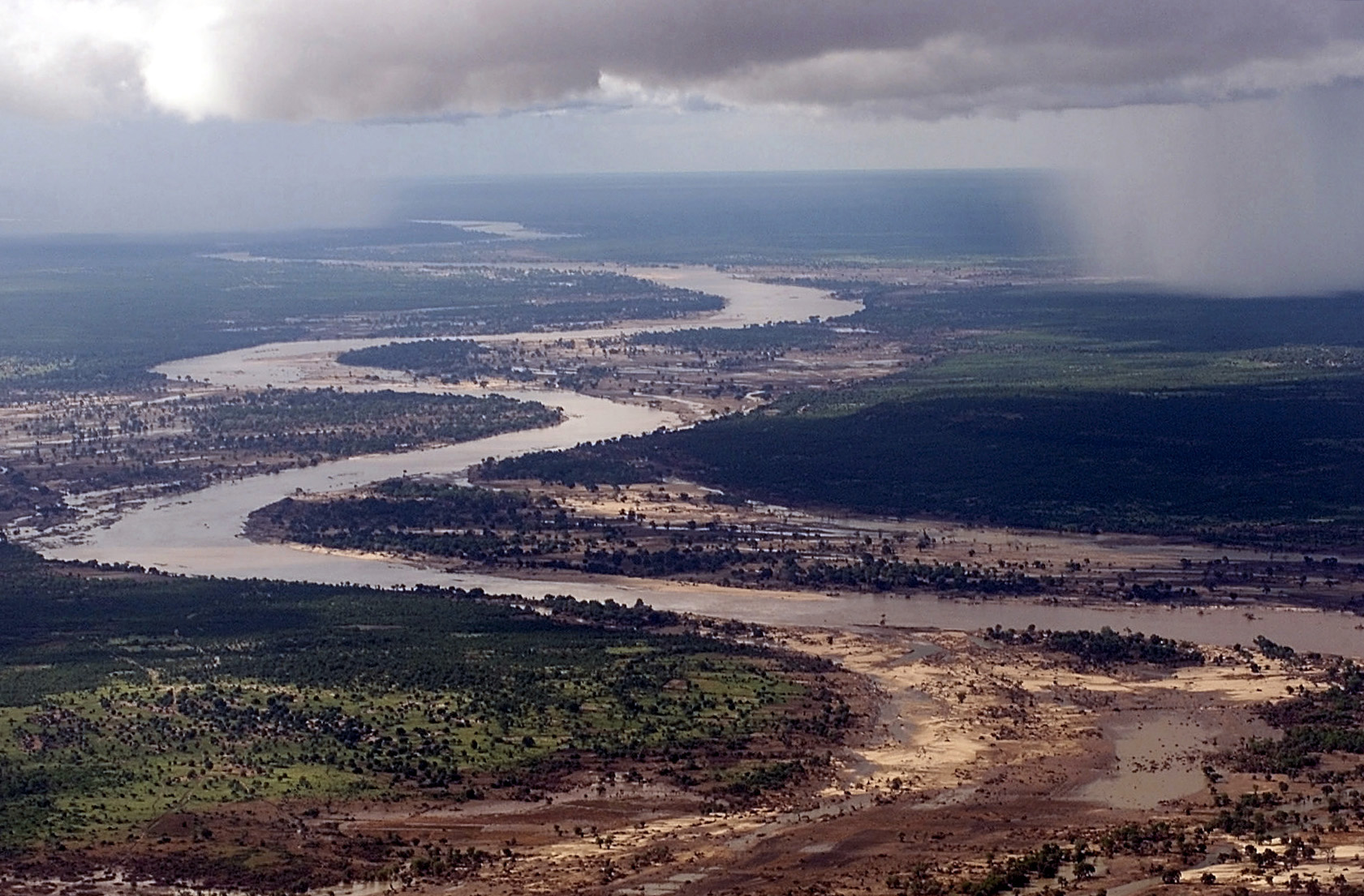
The Limpopo River (/lɪmˈpoʊpoʊ/) rises in South Africa and flows generally eastward through Mozambique to the Indian Ocean. The river is approximately 1,750 km (1,090 mi) long, with a drainage basin of 415,000 km2 (160,000 mi2) in size. The mean discharge measured over a year is 170 m3/s (6,000 cu ft/s) to 313 m3/s (11,100 cu ft/s) at its mouth. The Limpopo is the second largest African river that drains to the Indian Ocean, after the Zambezi.
The first European to sight the river was Vasco da Gama, who anchored off its mouth in 1498 and named it Rio do Espírito Santo (lit. 'River of the Holy Spirit'). Its lower course was explored by St Vincent Whitshed Erskine in 1868–69, and Captain J F Elton travelled down its middle course in 1870. The river has been called the Vhembe by local Venda communities of the area where now that name has been adopted by the South African government as its District Municipality in the north.
The drainage area of the Limpopo has decreased over geological time. Up to Late Pliocene or Pleistocene times, the upper course of the Zambezi River drained into the Limpopo River. The change of the drainage divide is the result of epeirogenic movement that uplifted the surface north of present-day Limpopo River, diverting waters into Zambezi River.
The river flows in a great arc, first zigzagging north and then north-east, then turning east and finally south-east. It serves as a border for about 640 kilometres (398 mi), separating South Africa to the southeast from Botswana to the northwest and Zimbabwe to the north. At the confluence of the Marico River and the Crocodile River, the name becomes the Limpopo River. There are several rapids as the river falls off Southern Africa's inland escarpment.
The Notwane River is a major tributary of the Limpopo, rising on the edge of the Kalahari Desert in Botswana and flowing in a north-easterly direction. The main tributary of the Limpopo, the Olifants River (Elephant River), contributes around 1,233 million m3 of water per year. Other major tributaries include the Shashe River, Mzingwane River, Crocodile River, Mwenezi River and Luvuvhu River.
In the north-eastern corner of South Africa the river borders the Kruger National Park. The port town of Xai-Xai, Mozambique, is on the river near the mouth. Below the Olifants, the river is navigable to the sea, though a sandbar prevents access by large ships except at high tide.
The waters of the Limpopo flow sluggishly, with considerable silt content. Rudyard Kipling's characterization of the river as the "great grey-green, greasy Limpopo River, all set about with fever-trees", where the "Bi-Coloured Python Rock-Snake" dwells in the Just So Stories is apt. Rainfall is seasonal and unreliable: in dry years, the upper parts of the river flow for 40 days or less. The upper part of the drainage basin, in the Kalahari Desert, is arid but conditions become less arid further downriver. The next reaches drain the Waterberg Massif, a biome of semi-deciduous forest and low-density human population. The fertile lowlands support a denser population, and about 14 million people live in the Limpopo basin. Flooding during the rainy season is an occasional problem in the lower reaches. During February 2000 heavy rainfalls during the passage of a cyclone caused the catastrophic 2000 Mozambique flood.
The highest concentration of hippopotamus in the Limpopo River is found between the Mokolo and the Mogalakwena Rivers. There is a lot of mining activity in the Limpopo River basin with about 1,900 functioning mines, not counting about 1,700 abandoned mines.
Hub AI
Limpopo River AI simulator
(@Limpopo River_simulator)
Limpopo River
The Limpopo River (/lɪmˈpoʊpoʊ/) rises in South Africa and flows generally eastward through Mozambique to the Indian Ocean. The river is approximately 1,750 km (1,090 mi) long, with a drainage basin of 415,000 km2 (160,000 mi2) in size. The mean discharge measured over a year is 170 m3/s (6,000 cu ft/s) to 313 m3/s (11,100 cu ft/s) at its mouth. The Limpopo is the second largest African river that drains to the Indian Ocean, after the Zambezi.
The first European to sight the river was Vasco da Gama, who anchored off its mouth in 1498 and named it Rio do Espírito Santo (lit. 'River of the Holy Spirit'). Its lower course was explored by St Vincent Whitshed Erskine in 1868–69, and Captain J F Elton travelled down its middle course in 1870. The river has been called the Vhembe by local Venda communities of the area where now that name has been adopted by the South African government as its District Municipality in the north.
The drainage area of the Limpopo has decreased over geological time. Up to Late Pliocene or Pleistocene times, the upper course of the Zambezi River drained into the Limpopo River. The change of the drainage divide is the result of epeirogenic movement that uplifted the surface north of present-day Limpopo River, diverting waters into Zambezi River.
The river flows in a great arc, first zigzagging north and then north-east, then turning east and finally south-east. It serves as a border for about 640 kilometres (398 mi), separating South Africa to the southeast from Botswana to the northwest and Zimbabwe to the north. At the confluence of the Marico River and the Crocodile River, the name becomes the Limpopo River. There are several rapids as the river falls off Southern Africa's inland escarpment.
The Notwane River is a major tributary of the Limpopo, rising on the edge of the Kalahari Desert in Botswana and flowing in a north-easterly direction. The main tributary of the Limpopo, the Olifants River (Elephant River), contributes around 1,233 million m3 of water per year. Other major tributaries include the Shashe River, Mzingwane River, Crocodile River, Mwenezi River and Luvuvhu River.
In the north-eastern corner of South Africa the river borders the Kruger National Park. The port town of Xai-Xai, Mozambique, is on the river near the mouth. Below the Olifants, the river is navigable to the sea, though a sandbar prevents access by large ships except at high tide.
The waters of the Limpopo flow sluggishly, with considerable silt content. Rudyard Kipling's characterization of the river as the "great grey-green, greasy Limpopo River, all set about with fever-trees", where the "Bi-Coloured Python Rock-Snake" dwells in the Just So Stories is apt. Rainfall is seasonal and unreliable: in dry years, the upper parts of the river flow for 40 days or less. The upper part of the drainage basin, in the Kalahari Desert, is arid but conditions become less arid further downriver. The next reaches drain the Waterberg Massif, a biome of semi-deciduous forest and low-density human population. The fertile lowlands support a denser population, and about 14 million people live in the Limpopo basin. Flooding during the rainy season is an occasional problem in the lower reaches. During February 2000 heavy rainfalls during the passage of a cyclone caused the catastrophic 2000 Mozambique flood.
The highest concentration of hippopotamus in the Limpopo River is found between the Mokolo and the Mogalakwena Rivers. There is a lot of mining activity in the Limpopo River basin with about 1,900 functioning mines, not counting about 1,700 abandoned mines.