Recent from talks
Nothing was collected or created yet.
Lincoln Sea
View on Wikipedia
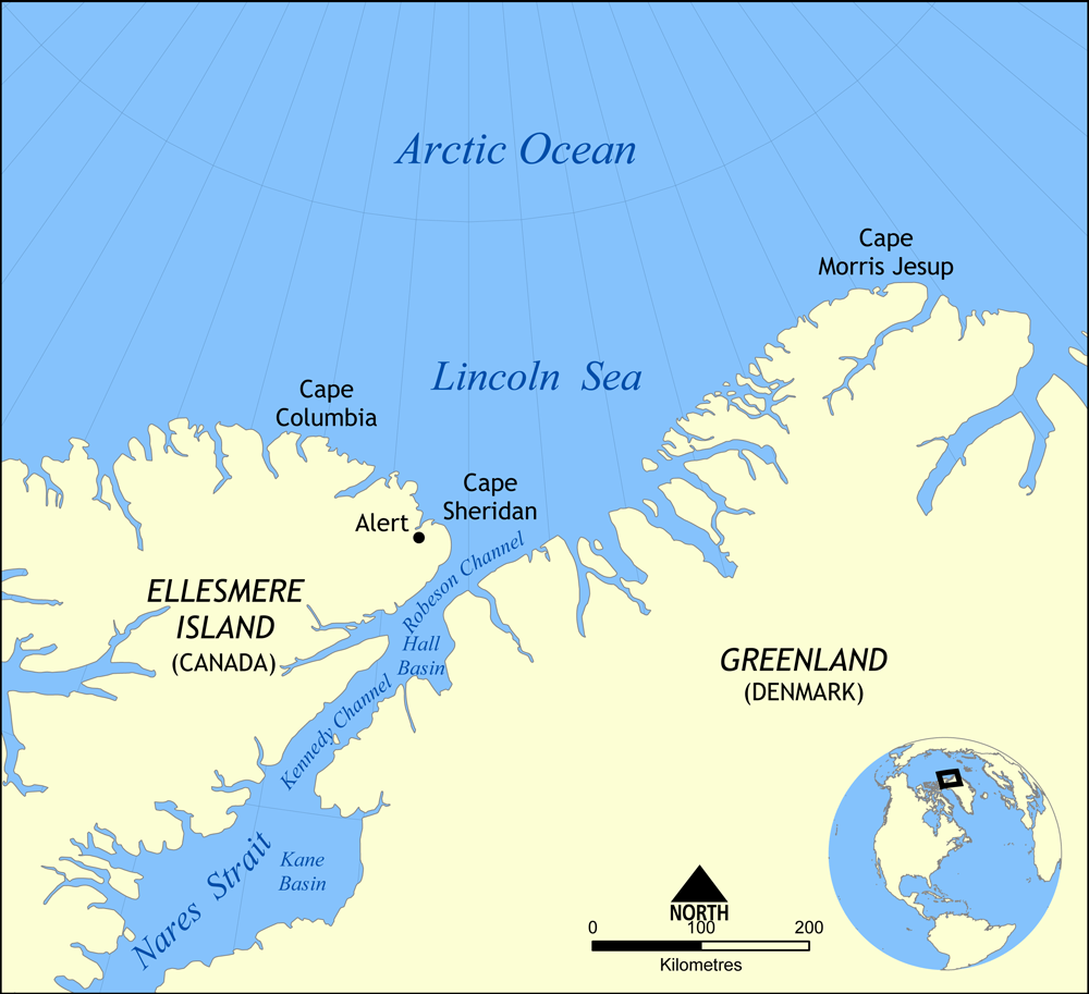
The Lincoln Sea (French: Mer de Lincoln; Danish: Lincolnhavet) is a body of water in the Arctic Ocean, stretching from Cape Columbia, Canada, in the west to Cape Morris Jesup, Greenland, in the east. The northern limit is defined as the great circle line between those two headlands. It is covered with sea ice throughout the year, the thickest sea ice in the Arctic Ocean, which can be up to 15 m (49 ft) thick. Water depths range from 100 m (330 ft) to 300 m (980 ft). Water and ice from Lincoln Sea empty into Robeson Channel, the northernmost part of Nares Strait, most of the time.
Key Information
The sea was named after Robert Todd Lincoln, then United States Secretary of War, on Adolphus W. Greely's 1881–1884 Arctic expedition into Lady Franklin Bay.[2]
Alert, the northernmost station of Canada, is the only populated place on the shore of the Lincoln Sea.
The body of water to the east of Lincoln Sea (east of Cape Morris Jesup) is the Wandel Sea.
Extent
[edit]The International Hydrographic Organization defines the limits of the Lincoln Sea as follows:[3]
On the North. Cape Columbia to Cape Morris Jesup (Greenland).
On the South. Cape Columbia through Northeastern shore of Ellesmere Island to Cape Sheridan to Cape Bryant (Greenland) through Greenland to Cape Morris Jesup.
Currents and Oceanic Circulation
[edit]Because of the severe ice conditions that last year-round, oceanographic measurements of the Lincoln Sea have been all but impossible. Before the 1980s, only low-flying aircraft samplings and ground observations from ice islands could be attempted; these did not stray far from the shores of Greenland and the Canadian Arctic Archipelago due to the harsh environment. Between 1989 and 1994, the field experiments in Project Spinnaker were underway, implementing instrumentation that captured temperature and salinity profiles well into the heart of the Lincoln Sea. Taken just east of where the North American continent intersects the Lomonosov Ridge, these observations revealed the oceanographic features and current formations within and surrounding the Lincoln Sea.
Along the continental margins of the Arctic Ocean basin, narrow boundary currents are hypothesized to house intense large-scale advection that is critical in the general circulation of Arctic waters. From the Bering Strait, Pacific Ocean waters flow counterclockwise (cyclonically) along the northern shores of Canada, passing through the Lincoln Sea. Atlantic Ocean waters cyclonically flow in from and return to the Eurasian basin along the Greenland Sea continental slope. The waters of these basins converge at the Lincoln Sea, creating unique vertical temperature and salinity profiles here. Measurements detail that both the Pacific and Eurasian Ocean water profiles are clearly offset from one another, an important facet of the hydrography of the Lincoln Sea.
The Lincoln Sea has been found to contain water with three distinct properties. The first concerns the water in the inner part of the Lincoln Sea shelf, where the temperature and salinity profiles increase from the surface to the seafloor. The second involves the water covering the outer part of the shelf, including the slope; the waters here hold attributes similar to those in the Canadian basin and thus not unlike those from the Pacific. The third includes the waters north of the shelf's slope. These waters protrude into the Arctic basin's large-scale circulation, and so their characteristics appear to change over to those found in the Eurasian basin.
Along the continental margins of the Arctic Ocean basin, narrow boundary currents are hypothesized to house intense large-scale advection that is critical in the general circulation of Arctic waters. One of these boundary currents resides along the sloping edge of the Lincoln Sea shelf, between the base and the shelf break at approximately 1600 m. The current's strength is 5–6 cm/s, according to long-term measurements. Assuming an undercurrent with an average strength of 4 cm/s and dimensions of 50 km in length and 1000 m in depth, the transport delivered over the slope of the Lincoln Sea shelf would be 2 Sverdrups, where 1 Sverdrup equals 10^6 m^3/s. Measurements reveal that this undercurrent shares comparable features to that found in the Beaufort Sea, whose boundary currents are responsible for large-scale advection within the Arctic circulation. Because of this mutual oceanographic behavior, it has been determined that the Lincoln Sea undercurrent continuously flows and is a component of the boundary current system that spans between Alaska and Greenland along the northern shores of the Canadian archipelago.[4]
Sea Ice
[edit]In May 2004 and 2005, electromagnetic measurements from helicopters revealed insights into the thickness of the sea ice in the Lincoln Sea and surrounding waters. With thicknesses ranging between 3.9 and 4.2 m, multi-year ice dominates south of 84°N. First-year ice, with thicknesses ranging between 0.9 and 2.2 m, denotes the refreezing of the Lincoln Polynya ice. These helicopter measurements concur with satellite-based radar imagery as well as ground-based electromagnetic observations. Drifting buoys have exposed a southward drift of sea ice toward Ellesmere Island and Nares Strait. It has been concluded that shear in the Lincoln Sea narrow boundary current plays an important role in shifting and thus removing sea ice from the Arctic region.[5]
The majority of sea ice export takes place on the eastern edges of the Arctic Ocean circulation near Greenland through the Fram Strait. Sea ice export through the Canadian archipelago was originally assumed to be zero, but that is not the case. The Lincoln Sea contains very thick multi-year sea ice, and so was thought to be stationary because of the apparent lack of oceanic outlets. However, according to a Canadian sea ice study, an area of approximately 22500 km2 of multi-year sea ice is drained through the Nares Strait each year. During the Northern Hemisphere winter, an area of about 225 km2 of ice reforms, resulting in 335 km2 of total sea ice drainage. Although this represents only one of the many pathways from the Arctic Ocean basin through the Canadian archipelago, "…this [total drainage] is an order of magnitude less than the flux of sea ice out of [the] Fram Strait."[6]
Dispute
[edit]A disagreement over a 200-square-kilometre section of the Lincoln Sea emerged after 1973 when Canada and Denmark signed a treaty[7] establishing the offshore boundary north of Canada's Ellesmere Island and Danish-controlled Greenland but left portions of it undefined.
From Canada's point of view, the point of focus in the Lincoln Sea dispute has been Denmark's inclusion of Beaumont Island (Greenland) (not to be confused with Beaumont Island off the west coast of Graham Land, Antarctica) off Greenland's northwest coast in calculating the boundary. The boundary is determined in that region by an "equidistance" principle that draws the line halfway between points along each country's coastline. Canada has basically argued that Beaumont Island is too insignificant to be used by Greenland to help determine the international boundary.[8]
In June 2022, Canada and Denmark formalized the maritime boundary between Nunavut and Greenland, including in the Lincoln Sea, and establishing a land border on Hans Island.[9]
References
[edit]- ^ R. Stein, Arctic Ocean Sediments: Processes, Proxies, and Paleoenvironment, p. 37
- ^ "Lincoln Sea, a sea in the Arctic Ocean". deepseawaters.com, Phoenix, Arizona. 2012. Retrieved 17 July 2012.
- ^ "Limits of Oceans and Seas, 3rd edition" (PDF). International Hydrographic Organization. 1953. Archived from the original (PDF) on 8 October 2011. Retrieved 28 December 2020.
- ^ Newton, John L.; Sotirin, Barbara J. (1997). "Boundary undercurrent and water mass changes in the Lincoln Sea". Journal of Geophysical Research: Oceans. 102 (C2): 3393–3403. Bibcode:1997JGR...102.3393N. doi:10.1029/96JC03441.
- ^ "Comparison of the sea-ice thickness distribution in the Lincoln Sea and adjacent Arctic Ocean in 2004 and 2005". International Glaciological Society. 2006. Retrieved 9 November 2013.[permanent dead link]
- ^ "Drainage of multi-year sea ice from the Lincoln Sea" (PDF). World Climate Research Program. 1998. Archived from the original (PDF) on 2013-11-11. Retrieved 10 November 2013.
- ^ "Canada and Kingdom of Denmark Reach Tentative Agreement on Lincoln Sea Boundary Backgrounder". Foreign Affairs and International Trade Canada. 2012. Archived from the original on 22 February 2014. Retrieved 16 February 2014.
- ^ "Canada, Denmark start talks to resolve border dispute" (PDF). Edmonton Journal. 2010. Archived from the original (PDF) on 12 May 2013. Retrieved 19 June 2012.
- ^ "Boundary dispute Backgrounder". Global Affairs Canada. 2022. Retrieved 14 June 2022.
External links
[edit]Lincoln Sea
View on GrokipediaGeography
Location and Boundaries
The Lincoln Sea is a marginal sea of the Arctic Ocean, positioned in the extreme northern latitudes between Ellesmere Island, part of Canada's Queen Elizabeth Islands, to the west and the northeastern coast of Greenland to the east.[5][8] It lies north of the Nares Strait and represents one of the northernmost bodies of water in the world, with its approximate central coordinates at 82°50′N 53°00′W.[9] The southern boundary of the Lincoln Sea follows the line extending from Cape Columbia on Ellesmere Island (at approximately 82°51′N 64°18′W) eastward to Cape Morris Jesup on Greenland (at approximately 83°38′N 33°22′W), separating it from the Wandel Sea to the south.[1][8] To the west, it is delimited by the irregular coastline of Ellesmere Island, while to the east, the boundary traces the rugged northern shoreline of Greenland, including Peary Land.[1][10] The northern extent merges seamlessly into the deeper waters of the central Arctic Ocean basin, without a sharply defined limit, encompassing an area influenced by the polar continental shelf.[11][12] These geographical boundaries align with the definitions outlined by the International Hydrographic Organization in its publication Limits of Oceans and Seas (3rd edition, 1953), which designates the Lincoln Sea as a distinct Arctic sub-basin (reference 17A).[13] Maritime jurisdictional boundaries within the Lincoln Sea were subject to negotiation between Canada and Denmark (representing Greenland), culminating in a 2022 agreement that resolved overlapping continental shelf claims and delimited exclusive economic zones, including the division of Hans Island.[5][14] This accord does not alter the physical oceanographic boundaries but clarifies sovereign resource rights over the seabed.[15]Extent and Bathymetry
The Lincoln Sea occupies a peripheral position in the Arctic Ocean, bounded to the south by the northern coasts of Ellesmere Island (Canada) and Greenland, specifically from Cape Columbia in the west to Cape Morris Jesup in the east, and extending northward over the continental shelf toward the central Arctic basin.[16][1] This configuration forms a funnel-shaped embayment approximately 400 kilometers wide at its southern limit, narrowing northward, with a total surface area of about 64,000 square kilometers.[8] Bathymetrically, the Lincoln Sea overlies a shallow continental shelf with depths generally less than 300 meters, characteristic of Arctic marginal seas, though local variations occur due to sparse historical sounding data primarily from wire-line and early echo-sounder surveys.[7] Average depths are estimated around 200-250 meters, with a maximum depth reaching approximately 300 meters in deeper shelf portions, beyond which a steep continental slope descends toward the Arctic deep basin.[8][11] Key topographic features include near-shore shallows off Ellesmere Island, where depths gradient rapidly from coastal zones, and a prominent bathymetric sill near the 300-meter contour that influences Atlantic water inflow and restricts exchange with adjacent deeper regions.[17][18] The seafloor substrate consists primarily of glacial sediments and rocky outcrops, with limited modern high-resolution mapping highlighting data gaps in southern sectors reliant on outdated Canadian Hydrographic Service spot soundings.[19] These bathymetric characteristics contribute to the sea's role as one of the deeper Arctic shelf areas, facilitating persistent multiyear ice formation over relatively uniform shelf topography while constraining oceanic circulation through sill-controlled pathways.[11][10]Oceanography
Currents and Circulation Patterns
The Lincoln Sea, positioned at the northwestern margin of the Arctic Ocean between Ellesmere Island and Greenland, exhibits weak and poorly defined mean surface currents, typically on the order of a few centimeters per second or less, owing to persistent sea ice cover and limited wind forcing in this peripheral region.[10] This sluggish surface flow reflects its location at the boundary between the anticyclonic Beaufort Gyre in the Canadian Basin and the more linear Transpolar Drift Stream, where broader Arctic circulation patterns converge without strong directional dominance.[20] Observations indicate that surface velocities are mechanically driven by episodic winds and modulated by density gradients from cooling, freezing, and freshwater inputs, but lack the vigor seen in ice-free Arctic sectors.[20] Subsurface circulation is dominated by a boundary undercurrent along the continental slope and shelf break, transporting modified Atlantic and Pacific waters poleward and eastward in a pattern consistent with the Arctic Circumpolar Boundary Current system.[10] Core velocities in this undercurrent reach approximately 5 cm/s, with mean flows directed similarly across moorings near the slope, facilitating water mass exchange between the central Arctic basins and the Lincoln Sea.[21] Tracer studies over multiple decades reveal spreading rates along these boundary pathways ranging from 0.7 to 1.5 cm/s, underscoring gradual ventilation of deeper waters without rapid turnover.[22] Overall patterns alternate between cyclonic and anticyclonic modes influenced by large-scale atmospheric pressure anomalies, with the Lincoln Sea acting as a transitional buffer where dense shelf water formation and freshwater anomalies from adjacent Nares Strait outflows further stratify and dampen circulation.[23] Limited observational data, primarily from moorings and hydrographic sections in the 1990s and 2000s, highlight variability tied to Arctic-wide changes, such as increased freshwater content altering density-driven flows between 2007 and 2010.[24]Physical and Chemical Properties
The waters of the Lincoln Sea are characterized by extremely low temperatures, with surface values typically at the freezing point of seawater, approximately -1.8°C, due to persistent sea ice cover and limited solar heating.[1] Deeper profiles show minimal warming, with temperatures increasing gradually to near 0°C in the halocline and remaining below 1°C in Atlantic-influenced layers below, reflecting the dominance of cold Arctic water masses.[7] On the inner shelf, temperature increases from surface to seafloor, contributing to convective instability and dense water formation.[1] Salinity exhibits a stratified profile, with fresher upper-ocean layers (around 30–32 practical salinity units, PSU) overlying saltier halocline waters (32–34 PSU) and deep basin values exceeding 34.5 PSU, driven by brine rejection from ice formation and limited freshwater input.[7] This structure supports the production of dense shelf waters that cascade into deeper basins. Variability includes a notable upper-ocean freshwater anomaly from 2007 to 2010, which lowered surface salinities basin-wide before reverting to higher pre-2007 levels (similar to 2003 observations) by 2011.[7] Density is predominantly governed by salinity gradients rather than temperature, typical of the Arctic Ocean halocline.[25] Chemically, dissolved oxygen concentrations are elevated, often reaching 12–14 mg/L in ventilated upper layers owing to high solubility in cold waters and minimal stratification-induced depletion, though halocline extrema reflect water mass modifications during shelf freezing.[26] [27] Nutrient profiles show moderate to high levels of nitrate (up to 10–15 μmol/L) and silicate (influenced by Pacific water advection via the Arctic interior), with lower phosphate, supporting limited primary production under ice; these vary with inflows through Nares Strait.[28] Seawater pH aligns with Arctic norms, approximately 8.0–8.1, modulated by low biological activity and CO₂ undersaturation in surface layers.[28]Sea Ice Characteristics
Formation and Seasonal Dynamics
Sea ice in the Lincoln Sea forms primarily through thermodynamic processes during autumn and winter, initiated when sea surface temperatures fall below -1.8°C, allowing frazil ice crystals to nucleate and aggregate into nilas and pancake ice within leads, polynyas, and any residual open water.[29] This process typically begins in September or October, coinciding with the onset of freezing conditions across the central Arctic Ocean, and is enhanced by cold air outbreaks that promote rapid heat loss from the ocean surface.[30] Advection of multiyear ice from the Arctic Ocean interior via the Transpolar Drift further contributes to the cover, with new ice growth occurring at the underside through conductive heat flux and brine rejection.[29] The seasonal cycle features pronounced thickness variations, with a peak-to-peak amplitude of approximately 1.2 m in the Last Ice Area encompassing the Lincoln Sea, driven mainly by winter thermodynamic accretion adding up to 1 m or more of new ice.[29] Modal multiyear ice thicknesses, including snow cover, reach 3.9–4.7 m by April, reflecting cumulative growth from October onward under persistent subfreezing conditions and minimal dynamic deformation due to the region's compact, slow-moving pack.[31] Ice concentration remains near 100% year-round, with limited extent variability compared to other Arctic regions, as the Lincoln Sea's position north of the Canadian Arctic Archipelago and Greenland minimizes seasonal openings.[30] [29] In summer, from June to August, thinning predominates through surface ablation from solar radiation and sensible heat, alongside minor bottom melt from relatively cold underlying waters, resulting in reductions of 1.2–1.7 m for multiyear ice parcels from spring maxima.[32] Seasonal ice arches in the adjacent Nares Strait, forming in winter or early spring, stabilize landfast ice and restrict export, but their collapse—typically in July or August, though earlier in anomalous years like 2017—can introduce dynamic variability by allowing increased motion and potential lead formation.[33] [30] Overall, these dynamics maintain the Lincoln Sea as a refuge for old ice, with freeze-up and consolidation outweighing thaw until the following autumn.[29]Multiyear Ice and Persistence
The Lincoln Sea hosts a significant proportion of Arctic multiyear sea ice (MYI), defined as ice that has survived at least one summer melt season, leading to greater thickness and structural integrity than first-year ice. Observational data from ice stations in 2013 recorded MYI thicknesses ranging from 1.5 to 4.5 meters, with spatial variations reflecting ridging and deformation processes typical of the region's compressive ice dynamics.[34] Airborne electromagnetic surveys during spring-to-summer transitions have quantified average MYI drafts of 2-3 meters, underscoring the ice's role in maintaining regional albedo and insulating the ocean from atmospheric heat.[35] Persistence of MYI in the Lincoln Sea stems from its northern position within the "last ice area," where persistent cold outflows from the Canadian Arctic Archipelago and Greenland limit oceanic heat advection, reducing summer melt rates compared to Atlantic-influenced sectors. Unlike the broader Arctic, where MYI extent has declined by over 50% since 2007 due to increased export through Fram Strait and enhanced bottom melt, the Lincoln Sea retains higher MYI fractions, with concentrations often exceeding 80% of total ice cover during winter maxima.[36] [37] Proxy records indicate that perennial ice persistence contrasts with Early Holocene conditions, when southern Lincoln Sea experienced seasonal ice retreat amid warmer climates, highlighting the current cover's dependence on sustained low temperatures.[38] Despite relative stability, MYI in the Lincoln Sea shows signs of thinning, with Lagrangian studies documenting 0.5-1.5 meter reductions over single summer seasons from surface ablation and basal melt, driven by episodic warm air intrusions.[31] Satellite-derived thickness products confirm modal values decreasing from 3 meters in the early 2000s to 2-2.5 meters by the 2020s, though the region's isolation buffers it against total loss projected for other Arctic basins.[39] This persistence supports ecological refugia but increases vulnerability to episodic events like the 2020 extended melt season, where anomalous warmth accelerated surface ponding and melt pond evolution on MYI floes.[40]Historical Context
Naming and Early Recognition
The Lincoln Sea was named by United States Army officer Adolphus Washington Greely during the Lady Franklin Bay Expedition of 1881 to 1884, in honor of Robert Todd Lincoln, who served as Secretary of War from 1881 to 1885.[1][41] Greely, leading a party of 25 men, established Fort Conger at latitude 81°44′N on the shore of Lady Franklin Bay, which forms the southern boundary of the Lincoln Sea, and from there launched sledge parties that traversed and mapped portions of the sea's ice-covered expanse, reaching up to 83°24′N.[42] This expedition, part of the International Polar Year effort, marked the first systematic American scientific occupation in the high Arctic and provided initial bathymetric and meteorological data for the region, though it ended in tragedy with only six survivors rescued in June 1884 after severe starvation and isolation.[43] Prior to Greely's naming, the Lincoln Sea area received early recognition through the British Arctic Expedition of 1875 to 1876, commanded by Captain George Strong Nares, which first penetrated the sea via Robeson Channel aboard HMS Alert and HMS Discovery.[44] Nares's ships navigated northward through heavy ice, with Alert wintering at Discovery Harbour on the northern Ellesmere Island coast, enabling sledge explorations that confirmed the sea's existence as an arm of the Arctic Ocean bounded by Greenland and Canadian territories, though pack ice prevented further vessel transit.[45] This effort built on earlier 19th-century probes, such as Charles Francis Hall's Polaris expedition of 1871, which approached but did not fully delineate the northern waterways, establishing the Lincoln Sea's strategic position in polar geography amid quests for the Northeast Passage and North Pole.[46]Exploration and Scientific Expeditions
The Polaris Expedition (1871–1873), commanded by Charles Francis Hall, represented an early attempt to penetrate the high Arctic, navigating through Nares Strait and achieving a northern latitude of approximately 82°N in the vicinity of the Lincoln Sea before the ship was beset by ice.[47] The expedition's discoveries, including coastal features, were mapped extending into the Baffin Bay to Lincoln Sea region, contributing initial geographic knowledge despite the mission's tragic end with Hall's death and the crew's subsequent ordeal on drifting ice.[48] The Lady Franklin Bay Expedition (1881–1884), led by Adolphus W. Greely as part of the International Polar Year, established a base at Fort Conger on Ellesmere Island at 81°45′N and conducted extensive sledge explorations northward across Lincoln Sea ice.[49] On May 13, 1882, Lieutenant James Booth Lockwood and Sergeant David Legrow Brainard attained a "farthest north" record of 83°24′N, involving overland and ice travel from the base.[45] The expedition prioritized scientific observations, including meteorology, magnetism, and astronomy, yielding datasets on Arctic climate and tides over two winters.[50] Robert E. Peary's multiple Arctic campaigns culminated in the 1908–1909 expedition, departing from the ship Roosevelt wintered off Cape Sheridan, Ellesmere Island, with the final push starting February 1, 1909, from Cape Columbia.[51] Peary's party traversed roughly 413 statute miles of multi-year sea ice across the Lincoln Sea, reaching the North Pole on April 6, 1909, at 90°N, supported by dog sleds and Inuit expertise.[51] This crossing provided qualitative insights into ice dynamics and ocean proximity, though Peary's pole claim remains debated due to navigational uncertainties.[52] Twentieth-century efforts transitioned to geophysical and oceanographic research. In 2006, a seismic refraction survey crossed the Lincoln Sea, confirming a deep sedimentary basin beneath the region with crustal thicknesses exceeding 30 km.[53] The LOMROG 2007 expedition, aboard the icebreaker Oden, mapped bathymetry and collected geological samples along the Lomonosov Ridge's southern flank north of Greenland, adjacent to the Lincoln Sea, aiding continental shelf delineation under UNCLOS. Hydrographic profiles from 2007–2010 revealed a marked increase in freshwater content, from 1,060 km³ to 2,380 km³, linked to enhanced ice melt and circulation shifts.[7] Recent expeditions have targeted cryospheric and ecosystem changes amid declining ice cover. The GEOEO North of Greenland 2024 mission, using the icebreaker Oden, penetrated the Lincoln Sea's heavy multi-year ice via Nares Strait in August, conducting the first extensive surface ship-based surveys of seabed morphology, ice-ocean interactions, and paleoceanographic coring in this remote basin.[54] Operations included multibeam echosounding and sub-bottom profiling to reconstruct glacial history and assess multi-year ice persistence, with the vessel reaching uncharted fjords and offshore areas previously limited to airborne or submarine access.[55] These efforts underscore the Lincoln Sea's role as a refuge for old ice, informing models of Arctic amplification.[56]Territorial Claims
Canada-Denmark Maritime Boundary
The 1973 Agreement between Canada and the Kingdom of Denmark concerning the delimitation of the continental shelf in the area between Greenland and Canada established a dividing line between the Canadian Arctic islands and Greenland, extending northward but stopping short of the Lincoln Sea.[6] This treaty addressed continental shelf jurisdiction within approximately 200 nautical miles but left the overlying waters and the Lincoln Sea boundary unresolved, prompting divergent interpretations.[57] Canada advocated for a direct northward extension of the 1973 line into the Lincoln Sea, maintaining that this equidistant approach aligned with established precedents and preserved Canadian interests adjacent to Ellesmere Island.[5] Denmark, however, proposed an alternative boundary incorporating a median line or adjustments accounting for Greenland's coastal features, which would have allocated a larger portion of the Lincoln Sea—estimated at around 1,200 square nautical miles—to Danish jurisdiction, potentially including areas Canada viewed as proximate to its territory.[5] [57] These positions reflected standard principles of maritime delimitation under the United Nations Convention on the Law of the Sea, emphasizing equitable criteria such as coastal length and geographic configuration, though neither party escalated to formal arbitration.[5] On November 28, 2012, Canada and Denmark announced a tentative agreement to resolve the Lincoln Sea boundary by extending the 1973 continental shelf line directly northward through the water column, effectively endorsing Canada's proposed alignment and closing the gap without territorial concessions.[5] [57] This provisional deal, however, remained unratified for a decade amid broader Arctic negotiations.[58] The boundary was finalized on June 14, 2022, through a comprehensive agreement between Canada, Denmark, and Greenland, which incorporated the Lincoln Sea delimitation as part of resolving the Hans Island sovereignty dispute and related maritime zones in the Nares Strait and Kennedy Channel.[59] [6] The pact establishes a single maritime boundary within 200 nautical miles, extending the 1973 line into the Lincoln Sea and confirming cooperative management without overlap, thereby promoting stability in Arctic resource claims amid increasing navigation and potential hydrocarbon exploration.[60] [6] This resolution exemplifies bilateral diplomacy prioritizing legal clarity over unilateral assertions, with no reported challenges to its implementation as of 2025.[60]Resolution Efforts and Overlaps
In 1973, Canada and the Kingdom of Denmark signed a treaty establishing a maritime boundary between Greenland and Canada's Arctic islands up to the entrance of the Lincoln Sea, based on an equidistance line, but leaving the boundary within the Lincoln Sea itself unresolved.[15] This ambiguity arose from differing interpretations: Canada advocated for a strict median line from the 1973 endpoint, while Denmark sought adjustments under international law to account for nearby Danish islands, such as the uninhabited Henrik Krøyer Holme islets, which Denmark argued entitled it to an eastward shift in the boundary, resulting in overlapping exclusive economic zone (EEZ) claims covering approximately 1,200 square nautical miles in the Lincoln Sea.[15] [5] Resolution efforts intensified in the early 2010s amid rising Arctic interest in resources and navigation. On November 28, 2012, the two nations announced a tentative agreement on the Lincoln Sea maritime boundary, extending the equidistance line northward while incorporating minor adjustments for proportionality, though it required further technical and legal ratification that stalled due to domestic processes in both countries.[59] Negotiations linked this to the broader Hans Island dispute, where symbolic "whisky diplomacy" exchanges had maintained amicable relations since the 1980s without formal resolution.[58] The overlaps were fully addressed in a comprehensive package agreement signed on June 14, 2022, in Ottawa by Canada, Denmark, and Greenland, establishing a single maritime boundary within 200 nautical miles that modernizes the 1973 line, divides Hans Island equally along a central line (with Canada gaining the southern two-thirds and Denmark/Greenland the northern third), and confirms the Lincoln Sea boundary without further overlaps.[59] [60] This deal, ratified through domestic approvals, prioritizes cooperative Arctic management over unilateral claims, reflecting the low economic stakes in the ice-covered region but preempting future continental shelf extensions beyond 200 nautical miles under UNCLOS Article 76.[61] No active territorial disputes remain in the Lincoln Sea as of 2022, though extended continental shelf submissions to the Commission on the Limits of the Continental Shelf could introduce new delineations.[62]Ecology and Environment
Marine Ecosystems and Biodiversity
The marine ecosystems of the Lincoln Sea are dominated by perennial multi-year sea ice, fostering specialized ice-associated microbial communities that drive primary production under low-light, nutrient-limited conditions. Bacterial assemblages differ markedly between first-year ice and multi-year ice, with multi-year ice hosting more stable, psychrophilic taxa adapted to prolonged isolation, while first-year ice exhibits higher variability influenced by recent melt and under-ice water exchanges. Spring sea ice in the region demonstrates net heterotrophy, where community respiration exceeds gross primary production by ice algae and associated protists, indicating reliance on allochthonous organic carbon from underlying waters. These microbial foundations support sparse but resilient lower trophic levels, including copepods and other zooplankton that thrive in brine channels and under-ice habitats. Pelagic and benthic biodiversity remains low due to extreme temperatures averaging -1.8°C and extensive ice cover limiting photic zone penetration, with macrofaunal biomass typically ranging from 5 to 32 mg C m⁻² and species richness of 1 to 11 per 0.02 m² in comparable High Arctic benthic assemblages. Key fish species, such as Arctic cod (Boreogadus saida), form a critical trophic link, aggregating under ice floes to feed on zooplankton and serving as prey for higher predators; densities in the Lincoln Sea and adjacent Canadian Arctic waters are estimated at 20–40 g m⁻² wet weight. Invertebrate communities emphasize crustaceans, including amphipods and copepods, which dominate zooplankton biomass and contribute to energy transfer in the ice-algal-grazer food web. Marine mammals adapted to ice-edge habitats include ringed seals (Pusa hispida), whose presence in the Lincoln Sea dates to the Holocene and was reconfirmed by aerial surveys in mid-August 2019 documenting haul-outs on floes. These seals forage on Arctic cod and under-ice fish, whelping on stable multi-year ice that persists in the region longer than in southern Arctic sectors. Polar bears (Ursus maritimus) utilize the Lincoln Sea's ice for seal hunting, with the area functioning as a seasonal foraging corridor linked to the broader High Arctic subpopulation; however, persistent ice loss threatens this dependency. Cetaceans such as beluga whales (Delphinapterus leucas) occasionally enter from adjacent channels, but overall mammal diversity is constrained by the sea's remoteness and ice persistence, prioritizing species reliant on sympagic (ice-associated) production over open-water pelagic systems.[63][64][11][65][66][67][68][69]Human Impacts and Conservation
The Lincoln Sea experiences minimal direct human impacts owing to its persistent multiyear ice cover and extreme remoteness, which have historically limited access to scientific research expeditions rather than commercial or industrial activities.[70] No large-scale resource extraction, such as oil or gas drilling, has occurred in the region, though broader Arctic assessments highlight potential hydrocarbon reserves that could attract future interest as ice retreat enables access.[71] Commercial shipping remains negligible, with no established routes traversing the Lincoln Sea, unlike more navigable Arctic passages; however, projections indicate possible increases in vessel traffic contributing to risks like fuel spills or black carbon deposition if ice persistence declines further.[72] Pollution levels from anthropogenic sources are low, with studies detecting trace contaminants primarily transported via long-range atmospheric deposition or ocean currents rather than local emissions.[73] Fisheries activity is absent, as the area supports no commercial harvesting, preserving it from overexploitation seen in other Arctic zones.[74] Conservation efforts prioritize the Lincoln Sea's role as part of the Arctic's "Last Ice Area," focusing on safeguarding endemic ice-dependent ecosystems against emerging pressures. In 2019, Canada designated the Tuvaijuittuq Marine Protected Area (MPA) under the Oceans Act, encompassing approximately 166,919 square kilometers of northern Baffin Bay and the Lincoln Sea, including key multiyear ice habitats; this MPA prohibits bottom-contact fishing gear and oil/gas exploration to conserve biodiversity and carbon sequestration functions.[74][75] The REFUGE-ARCTIC initiative seeks to expand protections by advocating for a permanent MPA endorsed by the Arctic Council, integrating Indigenous knowledge with scientific monitoring to address biogeochemical changes.[70] These measures align with international commitments under frameworks like the UN Convention on the Law of the Sea, emphasizing ecosystem-based management amid territorial overlaps between Canada and Denmark.[76]Climate Change Influences
Observed Environmental Shifts
The Lincoln Sea, historically characterized by persistent multiyear sea ice, has exhibited thinning of ice cover in recent decades. Airborne electromagnetic surveys conducted in spring revealed modal thicknesses of multiyear ice ranging from 3.9 to 4.7 meters in the Lincoln Sea, which reduced to 2.2 to 3.0 meters by summer in adjacent Nares Strait, reflecting intensified surface and basal melt processes.[32] Observations from 2022 in the region documented high sea ice concentrations exceeding 95% through early July, followed by rapid floe disintegration and concentration declines, indicative of accelerated summer melt dynamics.[40] Hydrographic data indicate a marked increase in freshwater content within the Lincoln Sea from 2007 to 2010, with anomalies reaching up to 1,000 km³ compared to prior baselines, altering upper ocean stratification and potentially linked to enhanced ice melt and altered inflows from adjacent Arctic basins.[7] Satellite-derived trends in sea ice concentration for the Lincoln Sea show a decline of approximately 5-10% per decade from 1979 to 2018, though less pronounced than in other Arctic marginal seas, underscoring its relative persistence amid broader regional losses.[77] These shifts align with Arctic-wide amplification of warming, where surface air temperatures have risen at rates exceeding 3°C since the late 20th century, contributing to reduced ice resilience in the Lincoln Sea despite its position as a potential "last ice area."[78] Peer-reviewed analyses confirm that such changes, driven by thermodynamic forcing and increased open water fractions, have led to smoother ice profiles with fewer pressure ridges, facilitating further export and fragmentation.[79]Projections and Research Findings
Models project a continued decline in multi-year sea ice thickness and coverage in the Lincoln Sea, part of the Arctic's designated "Last Ice Area," where perennial ice was anticipated to persist longest amid regional warming. Simulations from eddy-resolving ocean models indicate that upper-ocean eddy kinetic energy across the broader Arctic Ocean could triple by the 2090s relative to early 21st-century baselines under high-emission scenarios approximating +4°C global warming, though increases in the Lincoln Sea remain minimal due to subdued baseline currents and stratification. [80] This surge stems from reduced sea ice friction enabling stronger geostrophic flows and baroclinic instabilities, potentially enhancing heat and nutrient transport but with limited direct impact in peripheral basins like the Lincoln Sea. [80] Airborne observations from 1993 to 2023 reveal a decadal decrease in pressure ridge density by 2.33 ridges per km (14.9%) and height by 0.14 m (10.4%) in the Lincoln Sea, signaling a shift toward thinner, more mobile ice cover. Projections extend this trend, forecasting a 10% per-decade reduction in ridge density and an 11% drop in atmospheric drag coefficient within the Last Ice Area through the late 21st century, driven by the replacement of deformed multi-year ice with first-year ice prone to fragmentation rather than ridging. [81] Such changes amplify ice export via gateways like Nares Strait, with anomalous ice arch collapses—observed in 2017 and 2019—projected to recur more frequently under sustained thinning, accelerating freshwater outflow and altering regional salinity. [81] Coupled climate models in CMIP ensembles often underestimate historical thick ice regimes (>4 m) in the Lincoln Sea and adjacent Canadian Arctic Archipelago, leading to biased projections of sea ice persistence; refined initializations with observed thickness distributions yield more realistic declines but highlight uncertainties in simulating deformation and thermodynamic losses. [82] Studies suggest summer ice-free conditions in the Last Ice Area could emerge as early as the 2030s–2040s under moderate-to-high emissions, contingent on amplified Arctic warming (2–3 times the global rate) eroding refugia, though paleo-records indicate prior Holocene ice retreats without collapse of dependent ecosystems. [29] These findings underscore the need for high-resolution modeling to resolve local dynamics, as coarser IPCC assessments may overlook the Lincoln Sea's role as a lingering ice exporter influencing pan-Arctic circulation. [82]References
- https://www.coastalwiki.org/wiki/Arctic_ocean
