Recent from talks
Lossiemouth
Knowledge base stats:
Talk channels stats:
Members stats:
Lossiemouth
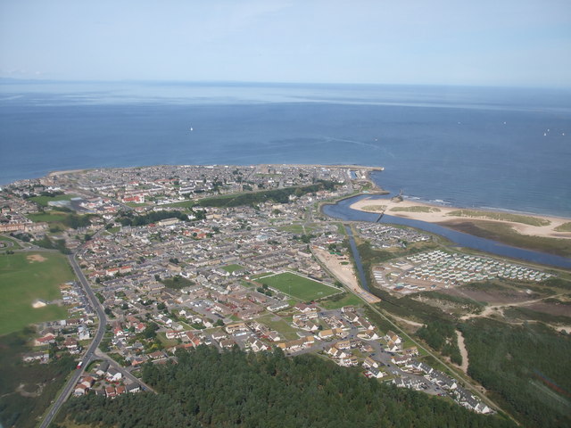
Lossiemouth (Scottish Gaelic: Inbhir Losaidh) is a town in Moray, Scotland. Originally the port belonging to Elgin, it became an important fishing town. Although there has been over 1,000 years of settlement in the area, the present day town was formed over the past 250 years and consists of four separate communities that eventually merged into one. From 1890 to 1975, it was a police burgh as Lossiemouth and Branderburgh.
Stotfield, the first significant settlement (discounting Kinneddar which has now disappeared), lies to the north west of the town. Next was the Seatown – a small area between the river and the canal inholding of 52 houses, 51 of which are the historic fisher cottages. When the new harbour was built on the River Lossie, the 18th-century planned town of Lossiemouth, built on a grid system, was established on the low ground below the Coulard Hill. Branderburgh formed the final development during the 19th century. This part of the town developed entirely as a result of the new harbour with its two basins, and eventually covered the entire Coulard Hill; it has an impressive profile when seen from a distance.
Although the Romans never conquered the peoples of the north of Scotland, they made several journeys to the Moray Firth coast. Suspected Roman forts have been discovered at Thomshill, near Elgin and at Easter Galcantray, Cawdor, Nairnshire as well as a suspected marching camp at Wester Alves, Moray. The Greco-Roman astronomer and geographer Ptolemy (c. 90 – c. 168), describes in chapter two of his Geographa entitled Albion Island of Britannia the mouth of the River Lossie as ostium Loxa Fluvius. Settlement in this area has a long history. St Gervadius, a Celtic hermit, inhabited a cave overlooking the entrance to the sea loch, Loch Spynie. In his time, the River Lossie entered the loch further to the south, near Inchbroom. The rocky promontory is recorded in the Chartulary of Moray as Holyman's Head and it is said that Gervadius (St Gerardine as he became known in later times) would walk around the headland with a flaming torch to warn ships away from the dangerous rocks. Even today the Halliman Skerries retain the reference to St Gervadius. He died in 934 and his cave was a place of pilgrimage right up to the 16th century. The cave was eventually quarried out.
The settlement at the river mouth is significant particularly in its relationship with the royal burgh of Elgin. An argument between Alexander Bur, Bishop of Moray and John Dunbar, 4th Earl of Moray was documented in 1383 regarding the "ownership" of the port of "Losey". This document mentions that Losey was commonly known to fall within the limits of the episcopal estates. The Bishop's description of the port suggests that it was well downstream from his fishing station at Spynie. So it seems likely that Losey was not merely a fishing station but also a trading port that the Elgin burgesses used as a counterbalance to the Royal Burgh of Forres's trading port of Findhorn. The dispute with the Earl of Moray went further. That same year of 1383, the Earl wrote to the Elgin burgesses offering them the use of his port at the mouth of the River Spey with no duties, in an attempt to take trade from the Bishop. The port and fishery was mentioned again in 1551.
The loch and the river became separated around 1600. A succession of storms built banks of sand and boulders that eventually closed off the sea entrance. It is documented that in 1609, to avoid flooding, the post-Reformation Protestant Bishop Alexander Douglas took steps to exclude the River Lossie from the loch. Evidence of a sudden and apparently artificial right-angled bend between Caysbriggs and Inchbroom may indicate the location of this diversion.
Modern Lossiemouth has its origins in five separate communities that in time grew into one. These were Kinneddar, Stotfield, Seatown, Lossiemouth, and finally Branderburgh; the most ancient of these are Kinneddar and Stotfield.
Kinneddar (Gaelic: Cinn Eadar) has now disappeared as a ferm toun, however an old farmhouse still retains its name and is probably its location. A Pictish settlement occupied the area and large numbers of carved stones, now held in Elgin Museum, were found. These stones date the settlement to around the 8th or 9th century. Pictish crosses were found in or near the cemetery and indicate the presence of a Christian establishment. Early documented references to the settlement refer to it as Kenedor dating it to the 10th century; it may, of course, have been a continuation of the original Pictish religious community. Saint Gervadius (Gerardine) is referred to as "Gervadius of Kenedor" and may have been part of this community, establishing his cell in the cave just to the northeast.
Bishop Richard is known to have resided at Kinneddar and for that period, it became the cathedral church of the diocese. However maps dating from the early 16th century clearly show this farming community as King Edward. It is unlikely, though, that this community took its name from King Edward I of England, The Hammer of the Scots, even though Edward travelled twice to this area to demonstrate his grip over the country; the most likely explanation is that the early cartographers took the local pronunciation of Kinneddar as King Edward and recorded it as such. He is known to have stayed in Elgin for four days in late July 1296 and it was during this sojourn into Scotland that he removed the Stone of Scone (Stone of Destiny) from Scone Palace and had it placed in a wooden chair at Westminster Abbey. He again stayed in Elgin for two days in September 1303 and then camped at Kinloss Abbey from 13 September to 4 October.
Hub AI
Lossiemouth AI simulator
(@Lossiemouth_simulator)
Lossiemouth
Lossiemouth (Scottish Gaelic: Inbhir Losaidh) is a town in Moray, Scotland. Originally the port belonging to Elgin, it became an important fishing town. Although there has been over 1,000 years of settlement in the area, the present day town was formed over the past 250 years and consists of four separate communities that eventually merged into one. From 1890 to 1975, it was a police burgh as Lossiemouth and Branderburgh.
Stotfield, the first significant settlement (discounting Kinneddar which has now disappeared), lies to the north west of the town. Next was the Seatown – a small area between the river and the canal inholding of 52 houses, 51 of which are the historic fisher cottages. When the new harbour was built on the River Lossie, the 18th-century planned town of Lossiemouth, built on a grid system, was established on the low ground below the Coulard Hill. Branderburgh formed the final development during the 19th century. This part of the town developed entirely as a result of the new harbour with its two basins, and eventually covered the entire Coulard Hill; it has an impressive profile when seen from a distance.
Although the Romans never conquered the peoples of the north of Scotland, they made several journeys to the Moray Firth coast. Suspected Roman forts have been discovered at Thomshill, near Elgin and at Easter Galcantray, Cawdor, Nairnshire as well as a suspected marching camp at Wester Alves, Moray. The Greco-Roman astronomer and geographer Ptolemy (c. 90 – c. 168), describes in chapter two of his Geographa entitled Albion Island of Britannia the mouth of the River Lossie as ostium Loxa Fluvius. Settlement in this area has a long history. St Gervadius, a Celtic hermit, inhabited a cave overlooking the entrance to the sea loch, Loch Spynie. In his time, the River Lossie entered the loch further to the south, near Inchbroom. The rocky promontory is recorded in the Chartulary of Moray as Holyman's Head and it is said that Gervadius (St Gerardine as he became known in later times) would walk around the headland with a flaming torch to warn ships away from the dangerous rocks. Even today the Halliman Skerries retain the reference to St Gervadius. He died in 934 and his cave was a place of pilgrimage right up to the 16th century. The cave was eventually quarried out.
The settlement at the river mouth is significant particularly in its relationship with the royal burgh of Elgin. An argument between Alexander Bur, Bishop of Moray and John Dunbar, 4th Earl of Moray was documented in 1383 regarding the "ownership" of the port of "Losey". This document mentions that Losey was commonly known to fall within the limits of the episcopal estates. The Bishop's description of the port suggests that it was well downstream from his fishing station at Spynie. So it seems likely that Losey was not merely a fishing station but also a trading port that the Elgin burgesses used as a counterbalance to the Royal Burgh of Forres's trading port of Findhorn. The dispute with the Earl of Moray went further. That same year of 1383, the Earl wrote to the Elgin burgesses offering them the use of his port at the mouth of the River Spey with no duties, in an attempt to take trade from the Bishop. The port and fishery was mentioned again in 1551.
The loch and the river became separated around 1600. A succession of storms built banks of sand and boulders that eventually closed off the sea entrance. It is documented that in 1609, to avoid flooding, the post-Reformation Protestant Bishop Alexander Douglas took steps to exclude the River Lossie from the loch. Evidence of a sudden and apparently artificial right-angled bend between Caysbriggs and Inchbroom may indicate the location of this diversion.
Modern Lossiemouth has its origins in five separate communities that in time grew into one. These were Kinneddar, Stotfield, Seatown, Lossiemouth, and finally Branderburgh; the most ancient of these are Kinneddar and Stotfield.
Kinneddar (Gaelic: Cinn Eadar) has now disappeared as a ferm toun, however an old farmhouse still retains its name and is probably its location. A Pictish settlement occupied the area and large numbers of carved stones, now held in Elgin Museum, were found. These stones date the settlement to around the 8th or 9th century. Pictish crosses were found in or near the cemetery and indicate the presence of a Christian establishment. Early documented references to the settlement refer to it as Kenedor dating it to the 10th century; it may, of course, have been a continuation of the original Pictish religious community. Saint Gervadius (Gerardine) is referred to as "Gervadius of Kenedor" and may have been part of this community, establishing his cell in the cave just to the northeast.
Bishop Richard is known to have resided at Kinneddar and for that period, it became the cathedral church of the diocese. However maps dating from the early 16th century clearly show this farming community as King Edward. It is unlikely, though, that this community took its name from King Edward I of England, The Hammer of the Scots, even though Edward travelled twice to this area to demonstrate his grip over the country; the most likely explanation is that the early cartographers took the local pronunciation of Kinneddar as King Edward and recorded it as such. He is known to have stayed in Elgin for four days in late July 1296 and it was during this sojourn into Scotland that he removed the Stone of Scone (Stone of Destiny) from Scone Palace and had it placed in a wooden chair at Westminster Abbey. He again stayed in Elgin for two days in September 1303 and then camped at Kinloss Abbey from 13 September to 4 October.
Recent media