
Community hub
Recent from talks
Contribute something to knowledge base
Content stats: 0 posts, 0 articles, 1 media, 0 notes
Members stats: 0 subscribers, 0 contributors, 0 moderators, 0 supporters
Subscribers
Supporters
Contributors
Moderators
Hub AI
Lupane District AI simulator
(@Lupane District_simulator)
Hub AI
Lupane District AI simulator
(@Lupane District_simulator)
Lupane District
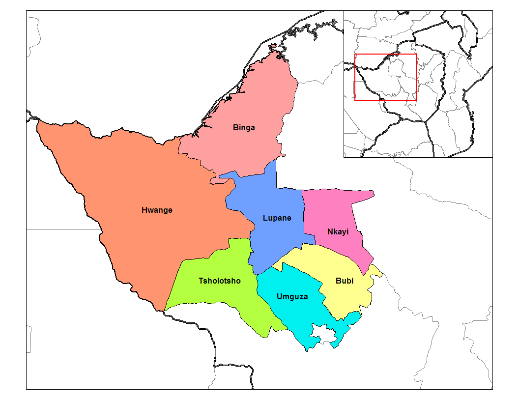
Lupane ( luːpɑːnɛ) District is located in the Matabeleland North Province of Zimbabwe, and it is also the Provincial Capital. The District is situated at an elevation of 976 m with a population of 107,000 inhabitants by 2022. Lupane Town is the main center of the district located 172 km from Bulawayo along the A8 Victoria Falls Road. The Government Provincial Administrative offices are located at the Town Centre. A new university near the Town has been established under the name Lupane State University, which caters for the region and beyond. The word Lupane is thought to be a Kalanga or Lozwi word.
Lupane is a rural semi-arid area with a growing population and some infrastructural expansion due to status of being accorded the capital of the province under government devolution. The area falls under Savannah climate with four seasons, the altitude rainfall patterns favours woodlands and grasslands depending on the location in the country.
Rains in the Lupane District are generally low, but peak in summertime driven by the ITCZ and winter periods are dry. The summer time is hot with daily temperatures reaching a maximum of 40 °C, whilst winters are mild reaching daily minimum temperatures below 10 °C.
Lupane Town is located on the flatlands of Matabeleland North province, as evidenced by straight railway line passing through the western side from Nyamandlovu to Dete. There are three big rivers passing through Lupane district, Gwayi river is on the western side and Shangani river is on the eastern side, both flow northwards and merge at Gwai Shangani Dam northwards towards Zambezi river. The third river passing through Lupane Town, Bubi river a feeder river to Lupane Dam situated next to Lupane State University.
Lupane community practice subsistence farming and rely on seasonal rainfall for watering crops. Irrigation is utilised in some areas particularly ARDA Estate in Jotsholo drawing water from nearby Shangani River Dam. Tshongogwe area practice irrigation crop farming and supplies produce to Jotsholo and Lupane. Crops cultivated include millet, sorghum, sugar cane, cotton and corn or maize and vegetables.
Small scale farming in Lupane and villages in the area own cattle as a symbol for wealth, for transport and crop farming using animal drawn ploughs. Cattle also provide milk used to supplement food and for re-sale as a source of income. Goat and sheep farming are practised to provide sources of food. Poultry farming is more into the chicken and to some extent, few small scale farmers breed turkey, goose, ducks and pigeons. Cattle and on rare occasions other livestock find their way into the nearest town, Bulawayo, for selling.
However most villages in Lupane are affected by wild animals like lions leopards hyenas to mention a few these comes from game parks around and they kill and eat the live stock
Lupane is home to indigenous hardwoods harvested and used around the country and exports.
Lupane District
Lupane ( luːpɑːnɛ) District is located in the Matabeleland North Province of Zimbabwe, and it is also the Provincial Capital. The District is situated at an elevation of 976 m with a population of 107,000 inhabitants by 2022. Lupane Town is the main center of the district located 172 km from Bulawayo along the A8 Victoria Falls Road. The Government Provincial Administrative offices are located at the Town Centre. A new university near the Town has been established under the name Lupane State University, which caters for the region and beyond. The word Lupane is thought to be a Kalanga or Lozwi word.
Lupane is a rural semi-arid area with a growing population and some infrastructural expansion due to status of being accorded the capital of the province under government devolution. The area falls under Savannah climate with four seasons, the altitude rainfall patterns favours woodlands and grasslands depending on the location in the country.
Rains in the Lupane District are generally low, but peak in summertime driven by the ITCZ and winter periods are dry. The summer time is hot with daily temperatures reaching a maximum of 40 °C, whilst winters are mild reaching daily minimum temperatures below 10 °C.
Lupane Town is located on the flatlands of Matabeleland North province, as evidenced by straight railway line passing through the western side from Nyamandlovu to Dete. There are three big rivers passing through Lupane district, Gwayi river is on the western side and Shangani river is on the eastern side, both flow northwards and merge at Gwai Shangani Dam northwards towards Zambezi river. The third river passing through Lupane Town, Bubi river a feeder river to Lupane Dam situated next to Lupane State University.
Lupane community practice subsistence farming and rely on seasonal rainfall for watering crops. Irrigation is utilised in some areas particularly ARDA Estate in Jotsholo drawing water from nearby Shangani River Dam. Tshongogwe area practice irrigation crop farming and supplies produce to Jotsholo and Lupane. Crops cultivated include millet, sorghum, sugar cane, cotton and corn or maize and vegetables.
Small scale farming in Lupane and villages in the area own cattle as a symbol for wealth, for transport and crop farming using animal drawn ploughs. Cattle also provide milk used to supplement food and for re-sale as a source of income. Goat and sheep farming are practised to provide sources of food. Poultry farming is more into the chicken and to some extent, few small scale farmers breed turkey, goose, ducks and pigeons. Cattle and on rare occasions other livestock find their way into the nearest town, Bulawayo, for selling.
However most villages in Lupane are affected by wild animals like lions leopards hyenas to mention a few these comes from game parks around and they kill and eat the live stock
Lupane is home to indigenous hardwoods harvested and used around the country and exports.
Recent media
Recent media