
Community hub
Recent from talks
Contribute something to knowledge base
Content stats: 0 posts, 0 articles, 1 media, 0 notes
Members stats: 0 subscribers, 0 contributors, 0 moderators, 0 supporters
Subscribers
Supporters
Contributors
Moderators
Hub AI
Maraetai AI simulator
(@Maraetai_simulator)
Hub AI
Maraetai AI simulator
(@Maraetai_simulator)
Maraetai
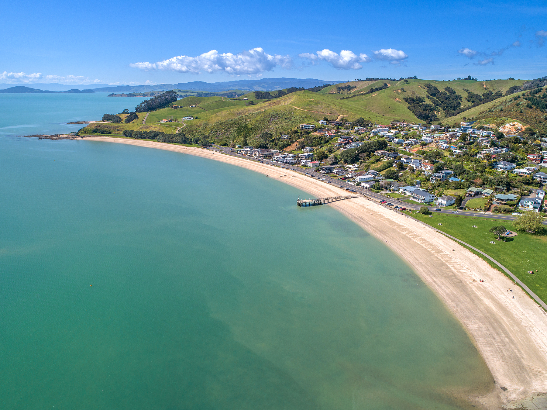
Maraetai is a coastal town to the east of Auckland in New Zealand, on the Pōhutukawa Coast. Part of the traditional rohe of Ngāi Tai Ki Tāmaki, the area developed into a coastal holiday community in the early 20th Century.
Maraetai is located adjacent to the Tāmaki Strait, in the Hauraki Gulf of New Zealand, 24 kilometres east of the Auckland City Centre. Maraetai has a number of bays and beaches, including Omana Beach, Te Pene Beach, Ohinerangi Beach, Waiomanu Beach and Magazine Bay. The closest town, Beachlands, lies approximately 4 kilometres to the west.
The Pōhutukawa Coast was visited by the Tainui migratory waka around the year 1300. Tainui followers of Manawatere, who identified as Ngā Oho, decided to settle the area between the Pōhutukawa Coast and Tūwakamana (Cockle Bay). Ngāi Tai ki Tāmaki, the mana whenua of the area, descend from these early settlers. Ngāi Tai ki Tāmaki traditional stories talk about the land already being occupied by the supernatural Tūrehu people, and many place names in the area reference Tūrehu figures, such as Hinerangi and Manawatere.
The name Maraetai is a traditional name for the Tāmaki Strait meaning "Marae Enclosed by the Tides", referring to how the sheltered ocean of the strait acted like a flat marae ātea (marae entrance courtyard). The name traditionally referred to the wider area between Motukaraka Island and the Wairoa River. Traditional names associated with modern Maraetai include Ōmanawatere, the name of Manawatere's pā and kāinga, Pōhaturoa, the name of the western Maraetai Beach as far as the Ōhinerangi stone, and Papawhitu, the name of the headland pā at modern Maraetai Point. Maraetai was a customary food gathering area, and around 200 people lives at the Papawhitu Pā, established in the 16th century.
When William Thomas Fairburn visited the area in 1833, it was mostly unoccupied due to the events of the Musket Wars, as most members of Ngāi Tai had fled to temporary refuge in the Waikato. In 1836, Fairburn purchased 40,000 acres between Ōtāhuhu and Umupuia (Duders Beach), including much of the catchment of the Wairoa River. Fairburn established a mission at Maraetai in 1837, where he taught reading, writing and spread Christianity among Ngāi Tai and Ngāti Pāoa. Fairburn resigned from the mission in 1841, and the mission was continued on Wiremu Hoete, until late 1843. Many Ngāi Tai and Ngāti Pāoa lived at the mission, and the farm surrounding the mission became one of the first farms in Auckland.
In 1851, Welsh farmer Thomas Eckford bought 368 acres from Fairburn around Maraetai as farmland, and the area was a site for kauri logging. In 1854, a portion of Fairburn's purchase between Maraetai Beach and Umupuia was designated as a reserve for Ngāi Tai. In September 1863 during the Invasion of the Waikato, the Ngāi Tai village of Ōtau near Clevedon was attacked by the British army, and the village was evacuated, living in communities at the river's mouth. For the remainder of the war, Ngāi Tai were designated as a "friendly" people by the Crown, and remained neutral in the fighting. After the Native Lands Act of 1865, the Native Land Court confiscated many Ngāi Tai lands. The remaining land was individuated, slowly sold on to European farmers. In 1877, the farmer Thomas Eckford sold his farm to George Couldrey.
The area was predominantly rural and sparsely populated in the 19th Century, and by the early 20th Century became a popular spot for picnics and camping. The Maraetai Highway District was established in 1875, and the first school opened in 1880. In the 1920s the area was subdivided. Sections of the Maraetai Beach Estate are advertised for sale in 1923, followed by the Omana Beach Estate in 1924. The Maraetai Hall was built in a single day on Labour Day 1926 as a community effort, and in 1929 the first bus service began, linking Maraetai, Beachlands and Whitford to Auckland.
Suburban housing in Maraetai developed significantly in the 1960s and early 1970s. Maraetai's residents do not use city mains water and instead must use water tanks and bore water. Many residents prefer it to be kept this way to maintain the town's rural aspect. Maraetai's beaches are popular destinations for other Aucklanders and are often crowded in the summer months.
Maraetai
Maraetai is a coastal town to the east of Auckland in New Zealand, on the Pōhutukawa Coast. Part of the traditional rohe of Ngāi Tai Ki Tāmaki, the area developed into a coastal holiday community in the early 20th Century.
Maraetai is located adjacent to the Tāmaki Strait, in the Hauraki Gulf of New Zealand, 24 kilometres east of the Auckland City Centre. Maraetai has a number of bays and beaches, including Omana Beach, Te Pene Beach, Ohinerangi Beach, Waiomanu Beach and Magazine Bay. The closest town, Beachlands, lies approximately 4 kilometres to the west.
The Pōhutukawa Coast was visited by the Tainui migratory waka around the year 1300. Tainui followers of Manawatere, who identified as Ngā Oho, decided to settle the area between the Pōhutukawa Coast and Tūwakamana (Cockle Bay). Ngāi Tai ki Tāmaki, the mana whenua of the area, descend from these early settlers. Ngāi Tai ki Tāmaki traditional stories talk about the land already being occupied by the supernatural Tūrehu people, and many place names in the area reference Tūrehu figures, such as Hinerangi and Manawatere.
The name Maraetai is a traditional name for the Tāmaki Strait meaning "Marae Enclosed by the Tides", referring to how the sheltered ocean of the strait acted like a flat marae ātea (marae entrance courtyard). The name traditionally referred to the wider area between Motukaraka Island and the Wairoa River. Traditional names associated with modern Maraetai include Ōmanawatere, the name of Manawatere's pā and kāinga, Pōhaturoa, the name of the western Maraetai Beach as far as the Ōhinerangi stone, and Papawhitu, the name of the headland pā at modern Maraetai Point. Maraetai was a customary food gathering area, and around 200 people lives at the Papawhitu Pā, established in the 16th century.
When William Thomas Fairburn visited the area in 1833, it was mostly unoccupied due to the events of the Musket Wars, as most members of Ngāi Tai had fled to temporary refuge in the Waikato. In 1836, Fairburn purchased 40,000 acres between Ōtāhuhu and Umupuia (Duders Beach), including much of the catchment of the Wairoa River. Fairburn established a mission at Maraetai in 1837, where he taught reading, writing and spread Christianity among Ngāi Tai and Ngāti Pāoa. Fairburn resigned from the mission in 1841, and the mission was continued on Wiremu Hoete, until late 1843. Many Ngāi Tai and Ngāti Pāoa lived at the mission, and the farm surrounding the mission became one of the first farms in Auckland.
In 1851, Welsh farmer Thomas Eckford bought 368 acres from Fairburn around Maraetai as farmland, and the area was a site for kauri logging. In 1854, a portion of Fairburn's purchase between Maraetai Beach and Umupuia was designated as a reserve for Ngāi Tai. In September 1863 during the Invasion of the Waikato, the Ngāi Tai village of Ōtau near Clevedon was attacked by the British army, and the village was evacuated, living in communities at the river's mouth. For the remainder of the war, Ngāi Tai were designated as a "friendly" people by the Crown, and remained neutral in the fighting. After the Native Lands Act of 1865, the Native Land Court confiscated many Ngāi Tai lands. The remaining land was individuated, slowly sold on to European farmers. In 1877, the farmer Thomas Eckford sold his farm to George Couldrey.
The area was predominantly rural and sparsely populated in the 19th Century, and by the early 20th Century became a popular spot for picnics and camping. The Maraetai Highway District was established in 1875, and the first school opened in 1880. In the 1920s the area was subdivided. Sections of the Maraetai Beach Estate are advertised for sale in 1923, followed by the Omana Beach Estate in 1924. The Maraetai Hall was built in a single day on Labour Day 1926 as a community effort, and in 1929 the first bus service began, linking Maraetai, Beachlands and Whitford to Auckland.
Suburban housing in Maraetai developed significantly in the 1960s and early 1970s. Maraetai's residents do not use city mains water and instead must use water tanks and bore water. Many residents prefer it to be kept this way to maintain the town's rural aspect. Maraetai's beaches are popular destinations for other Aucklanders and are often crowded in the summer months.
Recent media
Recent media