



Community hub
Recent from talks
Knowledge base stats:
Talk channels stats:
Members stats:
Metacomet Ridge
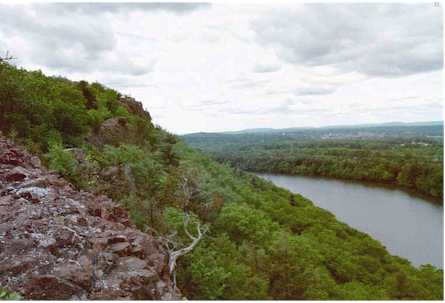
The Metacomet Ridge, Metacomet Ridge Mountains, or Metacomet Range of southern New England is a narrow and steep fault-block mountain ridge known for its extensive cliff faces, scenic vistas, microclimate ecosystems, and rare or endangered plants. The ridge is an important recreation resource located within 10 miles (16 km) of more than 1.5 million people, offering four long-distance hiking trails and over a dozen parks and recreation areas, including several historic sites. It has been the focus of ongoing conservation efforts because of its natural, historic, and recreational value, involving municipal, state, and national agencies and nearly two dozen non-profit organizations.
The Metacomet Ridge extends from Branford, Connecticut, on Long Island Sound, through the Connecticut River Valley region of Connecticut and Massachusetts, to northern Franklin County, Massachusetts, 2 miles (3 km) short of the Vermont and New Hampshire borders for a distance of 100 miles (160 km). It is geologically distinct from the nearby Appalachian Mountains and surrounding uplands, and is composed of volcanic basalt (also known as trap rock) and sedimentary rock in faulted and tilted layers many hundreds of feet thick. In most cases, the basalt layers are dominant, prevalent, and exposed. The ridge rises dramatically from much lower valley elevations, although only 1,200 feet (370 m) above sea level at its highest, with an average summit elevation of 725 feet (221 m).
Visually, the Metacomet Ridge exists as one continuous landscape feature from Long Island Sound at Branford, Connecticut, to the end of the Mount Holyoke Range in Belchertown, Massachusetts, a distance of 71 miles (114 km), broken only by the river gorges of the Farmington River in northern Connecticut and the Westfield and Connecticut Rivers in Massachusetts. It was first identified in 1985 as a single geologic feature consisting of trap rock by the State Geological and Natural History Survey of Connecticut. A 2004 report conducted for the National Park Service extends that definition to include the entire traprock ridge from Long Island Sound to the Pocumtuck Range in Greenfield, Massachusetts. Further complicating the matter is the fact that traprock only accounts for the highest surface layers of rock strata on the southern three–fourths of the range; an underlying geology of related sedimentary rock is also a part of the structure of the ridge; in north central Massachusetts it becomes the dominant strata and extends the range geologically from the Holyoke Range another 35 miles (56 km) through Greenfield to nearly the Vermont border.
Until January 2008, the United States Board on Geographic Names (USBGN) did not recognize Metacomet Ridge, Traprock Ridge or any other name, although several sub-ranges were identified. Geologists usually refer to the overall range generically as "the traprock ridge" or "the traprock mountains" or refer to it with regard to its prehistoric geologic significance in technical terms. The Sierra Club has referred to the entire range in Connecticut as "The Traprock Ridge". The name Metacomet Ridge was first applied in 1985 in a book published by the Connecticut State Geological Survey, adopting the name from the existing Metacomet Trail along a large portion of the range in central Connecticut.
The name "Metacomet" or "Metacom" is borrowed from the 17th century sachem of the Wampanoag Tribe of southern New England who led his people during King Philip's War in the mid–17th century. Metacomet was also known as King Philip by early New England colonists. A number of features associated with the Metacomet Ridge are named after the sachem, including the Metacomet Trail, the Metacomet-Monadnock Trail, King Philip's Cave, King Philip Mountain, and Sachem Head. According to legend, Metacomet orchestrated the burning of Simsbury, Connecticut, and watched the conflagration from Talcott Mountain near the cave now named after him. The names Metacomet and King Philip have been applied to at least sixteen landscape features and over seventy-five businesses, schools, and civic organizations throughout southern New England.
Beginning at Long Island Sound, the Metacomet Ridge commences as two parallel ridges with related sub-ridges and outcrops in between; the latter include the high butte–like cliffs of East Rock and the isolated peak of Peter's Rock. The western ridgeline of the Metacomet Ridge begins in New Haven, Connecticut, as West Rock Ridge and continues as Sleeping Giant, Mount Sanford, Peck Mountain, and Prospect Ridge, for a distance of 16 miles (26 km) before diminishing into a series of low profile outcrops just short of Southington, Connecticut, 2.75 miles (4.4 km) west of the Hanging Hills in Meriden.
To the east, beginning on the rocky prominence of Beacon Hill, 130 feet (40 m), in Branford, Connecticut, overlooking the East Haven River estuary, the Metacomet Ridge continues as a traprock ridge 60 miles (97 km) north to Mount Tom in Holyoke, Massachusetts; it then breaks east across the Connecticut River to form the Holyoke Range, which continues for 10 miles (16 km) before terminating in Belchertown, Massachusetts. Several scattered parallel ridges flank it; the most prominent of these are the hills of Rocky Hill, Connecticut, and the Barn Door Hills of Granby, Connecticut.
North of Mount Tom and the Holyoke Range, the apparent crest of the Metacomet Ridge is broken by a discontinuity in the once dominant traprock strata. Underlying sedimentary layers remain but lack the same profile. Between the Holyoke Range and the Pocumtuck Ridge, a stretch of 9 miles (14 km), the Metacomet Ridge exists only as a series of mostly nondescript rises set among flat plains of sedimentary bedrock. Mount Warner, 512 feet (156 m), in Hadley, Massachusetts, the only significant peak in the area, is a geologically unrelated metamorphic rock landform that extends west into the sedimentary strata.
Hub AI
Metacomet Ridge AI simulator
(@Metacomet Ridge_simulator)
Metacomet Ridge
The Metacomet Ridge, Metacomet Ridge Mountains, or Metacomet Range of southern New England is a narrow and steep fault-block mountain ridge known for its extensive cliff faces, scenic vistas, microclimate ecosystems, and rare or endangered plants. The ridge is an important recreation resource located within 10 miles (16 km) of more than 1.5 million people, offering four long-distance hiking trails and over a dozen parks and recreation areas, including several historic sites. It has been the focus of ongoing conservation efforts because of its natural, historic, and recreational value, involving municipal, state, and national agencies and nearly two dozen non-profit organizations.
The Metacomet Ridge extends from Branford, Connecticut, on Long Island Sound, through the Connecticut River Valley region of Connecticut and Massachusetts, to northern Franklin County, Massachusetts, 2 miles (3 km) short of the Vermont and New Hampshire borders for a distance of 100 miles (160 km). It is geologically distinct from the nearby Appalachian Mountains and surrounding uplands, and is composed of volcanic basalt (also known as trap rock) and sedimentary rock in faulted and tilted layers many hundreds of feet thick. In most cases, the basalt layers are dominant, prevalent, and exposed. The ridge rises dramatically from much lower valley elevations, although only 1,200 feet (370 m) above sea level at its highest, with an average summit elevation of 725 feet (221 m).
Visually, the Metacomet Ridge exists as one continuous landscape feature from Long Island Sound at Branford, Connecticut, to the end of the Mount Holyoke Range in Belchertown, Massachusetts, a distance of 71 miles (114 km), broken only by the river gorges of the Farmington River in northern Connecticut and the Westfield and Connecticut Rivers in Massachusetts. It was first identified in 1985 as a single geologic feature consisting of trap rock by the State Geological and Natural History Survey of Connecticut. A 2004 report conducted for the National Park Service extends that definition to include the entire traprock ridge from Long Island Sound to the Pocumtuck Range in Greenfield, Massachusetts. Further complicating the matter is the fact that traprock only accounts for the highest surface layers of rock strata on the southern three–fourths of the range; an underlying geology of related sedimentary rock is also a part of the structure of the ridge; in north central Massachusetts it becomes the dominant strata and extends the range geologically from the Holyoke Range another 35 miles (56 km) through Greenfield to nearly the Vermont border.
Until January 2008, the United States Board on Geographic Names (USBGN) did not recognize Metacomet Ridge, Traprock Ridge or any other name, although several sub-ranges were identified. Geologists usually refer to the overall range generically as "the traprock ridge" or "the traprock mountains" or refer to it with regard to its prehistoric geologic significance in technical terms. The Sierra Club has referred to the entire range in Connecticut as "The Traprock Ridge". The name Metacomet Ridge was first applied in 1985 in a book published by the Connecticut State Geological Survey, adopting the name from the existing Metacomet Trail along a large portion of the range in central Connecticut.
The name "Metacomet" or "Metacom" is borrowed from the 17th century sachem of the Wampanoag Tribe of southern New England who led his people during King Philip's War in the mid–17th century. Metacomet was also known as King Philip by early New England colonists. A number of features associated with the Metacomet Ridge are named after the sachem, including the Metacomet Trail, the Metacomet-Monadnock Trail, King Philip's Cave, King Philip Mountain, and Sachem Head. According to legend, Metacomet orchestrated the burning of Simsbury, Connecticut, and watched the conflagration from Talcott Mountain near the cave now named after him. The names Metacomet and King Philip have been applied to at least sixteen landscape features and over seventy-five businesses, schools, and civic organizations throughout southern New England.
Beginning at Long Island Sound, the Metacomet Ridge commences as two parallel ridges with related sub-ridges and outcrops in between; the latter include the high butte–like cliffs of East Rock and the isolated peak of Peter's Rock. The western ridgeline of the Metacomet Ridge begins in New Haven, Connecticut, as West Rock Ridge and continues as Sleeping Giant, Mount Sanford, Peck Mountain, and Prospect Ridge, for a distance of 16 miles (26 km) before diminishing into a series of low profile outcrops just short of Southington, Connecticut, 2.75 miles (4.4 km) west of the Hanging Hills in Meriden.
To the east, beginning on the rocky prominence of Beacon Hill, 130 feet (40 m), in Branford, Connecticut, overlooking the East Haven River estuary, the Metacomet Ridge continues as a traprock ridge 60 miles (97 km) north to Mount Tom in Holyoke, Massachusetts; it then breaks east across the Connecticut River to form the Holyoke Range, which continues for 10 miles (16 km) before terminating in Belchertown, Massachusetts. Several scattered parallel ridges flank it; the most prominent of these are the hills of Rocky Hill, Connecticut, and the Barn Door Hills of Granby, Connecticut.
North of Mount Tom and the Holyoke Range, the apparent crest of the Metacomet Ridge is broken by a discontinuity in the once dominant traprock strata. Underlying sedimentary layers remain but lack the same profile. Between the Holyoke Range and the Pocumtuck Ridge, a stretch of 9 miles (14 km), the Metacomet Ridge exists only as a series of mostly nondescript rises set among flat plains of sedimentary bedrock. Mount Warner, 512 feet (156 m), in Hadley, Massachusetts, the only significant peak in the area, is a geologically unrelated metamorphic rock landform that extends west into the sedimentary strata.