

Community hub
Recent from talks
Contribute something
Nothing was collected or created yet.
Mont-Vully
View on WikipediaMont-Vully (French: [mɔ̃ vyji]; Arpitan: Mont-Vulyi) is a municipality in the district of See in the Canton of Fribourg in Switzerland. It was formed on 1 January 2016 when the former municipalities of Bas-Vully and Haut-Vully merged.[2]
Key Information


History
[edit]Haut-Vully is first mentioned around 968-85 as Vuisliacense. In 1453 it was mentioned as Vuilliez.[3]
Bas-Vully is first mentioned in 968 as Williacense. Until 1831 it was known as vor Commune générale des quatre villages de La Rivière. The municipality was formerly known by its German name Unterwistenlach; however, that name is no longer used.[4]
Geography
[edit]Mont-Vully has an area of 17.51 km2 (6.76 sq mi).[5]
Demographics
[edit]
Heritage sites of national significance
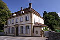
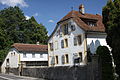
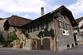
[edit]The House De W. J. Merz, the Gatschet House, the Les Rondas House, the De Steiger House, the d’Erlach-Velga House, the de Wattenwyl House and the oppidum of Mont Vully are listed as Swiss heritage site of national significance. The entire villages of Môtier and of Praz are part of the Inventory of Swiss Heritage Sites.[7]
-
 Gatschet House
 -
 Les Rondas House
 -
 De Steiger House
 -
 d’Erlach-Velga House
 -
 de Wattenwyl House
 -
 Mont Vully


World heritage site
[edit]It is home to the Môtier I prehistoric pile-dwelling (or stilt house) settlements that are part of the Prehistoric Pile dwellings around the Alps UNESCO World Heritage Site.[8]
The Môtier I site has been only lightly studied. It appears to be the site of a Neolithic settlement, based on the discovery of stone axes, but has not been more exactly dated. The site was discovered in 1860 by Colonel Schwab and may have contained decaying wooden piles during the 19th century. A small expedition in 2003 found a 70 cm (28 in) thick layer of artifacts. The settlement layer is buried under 50–250 cm (20–98 in) of earth and stretches over an area that is 190 m (620 ft) long and 50–70 m (160–230 ft) wide. The entire site is currently located on dry land and is covered by earth.[9]
Transportation
[edit]The municipality has a railway station, Sugiez, on the Fribourg–Ins line. It has regular service to Fribourg/Freiburg, Ins, and Neuchâtel.
References
[edit]- ^ "Arealstatistik Standard - Gemeinden nach 4 Hauptbereichen" (in German). Federal Statistical Office. Retrieved 13 January 2019.
- ^ Nomenklaturen – Amtliches Gemeindeverzeichnis der Schweiz (in German) accessed 3 February 2016
- ^ "Haut-Vully" in German, French and Italian in the online Historical Dictionary of Switzerland.
- ^ "Bas-Vully" in German, French and Italian in the online Historical Dictionary of Switzerland.
- ^ Arealstatistik Standard - Gemeindedaten nach 4 Hauptbereichen
- ^ "Ständige und nichtständige Wohnbevölkerung nach institutionellen Gliederungen, Geburtsort und Staatsangehörigkeit". bfs.admin.ch (in German). Swiss Federal Statistical Office - STAT-TAB. 31 December 2020. Retrieved 21 September 2021.
- ^ "Kantonsliste A-Objekte". KGS Inventar (in German). Federal Office of Civil Protection. 2009. Archived from the original on 28 June 2010. Retrieved 25 April 2011.
- ^ UNESCO World Heritage Site - Prehistoric Pile dwellings around the Alps
- ^ palafittes.org UNESCO nomination files-Volume I: Id-files of the component parts of the serial, Sites Switzerland (2) Archived 2012-04-25 at the Wayback Machine accessed 14-December-2011
External links
[edit]- Official website (in French)
- "Haut-Vully" in German, French and Italian in the online Historical Dictionary of Switzerland.
- "Bas-Vully" in German, French and Italian in the online Historical Dictionary of Switzerland.
- "Môtier" in German, French and Italian in the online Historical Dictionary of Switzerland.
- "Lugnorre" in German, French and Italian in the online Historical Dictionary of Switzerland.
- "Joressant" in German, French and Italian in the online Historical Dictionary of Switzerland.
- "Mur (FR)" in German, French and Italian in the online Historical Dictionary of Switzerland.
- "Guévaux" in German, French and Italian in the online Historical Dictionary of Switzerland.
Municipalities in See/Lac District, Switzerland | ||
|---|---|---|
| International | |
|---|---|
| Other | |