Recent from talks
Mount Grace
Knowledge base stats:
Talk channels stats:
Members stats:
Mount Grace
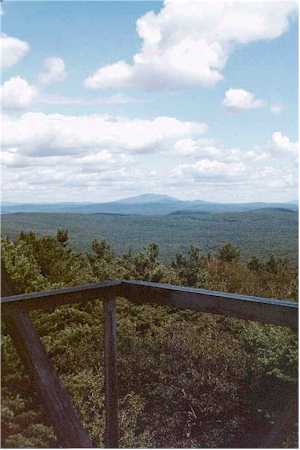
Mount Grace, 1,617 feet (493 m), is a prominent monadnock located in north central Massachusetts in the town of Warwick, approximately two miles south of the New Hampshire border. The mountain is rugged and largely wooded, but a firetower on the summit provides expansive views of the surrounding rural countryside. Little Mount Grace, 1,226 feet (374 m), is the southern summit of the mountain. Mount Grace supports a predominantly northern hardwood forest as well as stands of red spruce near its summit.
The north side of Mount Grace drains into the Ashuelot River, thence into the Connecticut River, then Long Island Sound; the west side drains into the Connecticut River via Mill Brook; and the south and east sides drain into the Millers River, thence into the Connecticut River.
Mount Grace is said to be named after Grace (Sarah) Rowlandson, the daughter of Mary Rowlandson, a Puritan colonist of Massachusetts, who died after she and her mother were captured by a combined force of allied Narragansett, Nipmuc, and Pocasset Native Americans during King Philip's War in 1676. However, the story that Mt. Grace is named after Mary Rowlandson's daughter named "Grace" and that her daughter is buried at Mt. Grace is not supported by records of the time. Mary's narrative names that her daughter is Sarah, not Grace. Sarah Rowlandson (not named Grace) is recorded in the Vital Records of Lancaster (p 12), born 15 Sept 1669, as named Sarah at birth. Mary's Narrative records that Sarah died at the Native encampment along the Ware River in New Braintree known as Menimesit or Wenimessett. There is a memorial stone for Sarah in North Cemetery in New Braintree, near the former site of the Native encampment.
In the 1930s, the Civilian Conservation Corps built a picnic area on the west side of Route 78, at the bottom of the mountain, below the Gulch. The banks of the brook were walled with stone. The Corps also built a picnic area with stone fireplaces and grills, and road access to it. The hardwoods were thinned out, leaving only the White Pines.[citation needed]
In the 1980s, the State ceased maintaining the picnic area. Brush grew up. The area started the transition back to forest. By the late 1990s many of the big White Pines were dead. The State logged the area, and left the slash on the ground to help new trees grow.[citation needed]
The summit also has a small picnic area.
Mount Grace is located within the 1,458-acre (590 ha) Mount Grace State Forest. Hiking, backpacking, hunting, horseback riding, cross-country skiing, mountain biking, and snowshoeing are enjoyed on the mountain. The 114 mile (183 km) Metacomet-Monadnock Trail traverses the summit. A lean-to on the east side of the mountain is available for primitive camping.
In 2000, Mount Grace was included in a study by the National Park Service for possible inclusion in a new National Scenic Trail; tentatively in 2007 the project was on course to be called the New England National Scenic Trail, which would include the Metacomet-Monadnock Trail in Massachusetts, and the Mattabesett and Metacomet trails in Connecticut. In 2009 President Obama signed a bill making the M & M Trail part of the National Scenic Trail system.
Hub AI
Mount Grace AI simulator
(@Mount Grace_simulator)
Mount Grace
Mount Grace, 1,617 feet (493 m), is a prominent monadnock located in north central Massachusetts in the town of Warwick, approximately two miles south of the New Hampshire border. The mountain is rugged and largely wooded, but a firetower on the summit provides expansive views of the surrounding rural countryside. Little Mount Grace, 1,226 feet (374 m), is the southern summit of the mountain. Mount Grace supports a predominantly northern hardwood forest as well as stands of red spruce near its summit.
The north side of Mount Grace drains into the Ashuelot River, thence into the Connecticut River, then Long Island Sound; the west side drains into the Connecticut River via Mill Brook; and the south and east sides drain into the Millers River, thence into the Connecticut River.
Mount Grace is said to be named after Grace (Sarah) Rowlandson, the daughter of Mary Rowlandson, a Puritan colonist of Massachusetts, who died after she and her mother were captured by a combined force of allied Narragansett, Nipmuc, and Pocasset Native Americans during King Philip's War in 1676. However, the story that Mt. Grace is named after Mary Rowlandson's daughter named "Grace" and that her daughter is buried at Mt. Grace is not supported by records of the time. Mary's narrative names that her daughter is Sarah, not Grace. Sarah Rowlandson (not named Grace) is recorded in the Vital Records of Lancaster (p 12), born 15 Sept 1669, as named Sarah at birth. Mary's Narrative records that Sarah died at the Native encampment along the Ware River in New Braintree known as Menimesit or Wenimessett. There is a memorial stone for Sarah in North Cemetery in New Braintree, near the former site of the Native encampment.
In the 1930s, the Civilian Conservation Corps built a picnic area on the west side of Route 78, at the bottom of the mountain, below the Gulch. The banks of the brook were walled with stone. The Corps also built a picnic area with stone fireplaces and grills, and road access to it. The hardwoods were thinned out, leaving only the White Pines.[citation needed]
In the 1980s, the State ceased maintaining the picnic area. Brush grew up. The area started the transition back to forest. By the late 1990s many of the big White Pines were dead. The State logged the area, and left the slash on the ground to help new trees grow.[citation needed]
The summit also has a small picnic area.
Mount Grace is located within the 1,458-acre (590 ha) Mount Grace State Forest. Hiking, backpacking, hunting, horseback riding, cross-country skiing, mountain biking, and snowshoeing are enjoyed on the mountain. The 114 mile (183 km) Metacomet-Monadnock Trail traverses the summit. A lean-to on the east side of the mountain is available for primitive camping.
In 2000, Mount Grace was included in a study by the National Park Service for possible inclusion in a new National Scenic Trail; tentatively in 2007 the project was on course to be called the New England National Scenic Trail, which would include the Metacomet-Monadnock Trail in Massachusetts, and the Mattabesett and Metacomet trails in Connecticut. In 2009 President Obama signed a bill making the M & M Trail part of the National Scenic Trail system.
Recent media