
Community hub
0 subscribers8 pages, 0 posts
Recent from talks
All channels
Be the first to start a discussion here.
Be the first to start a discussion here.
Be the first to start a discussion here.
Be the first to start a discussion here.
Contribute something
Welcome to the community hub built to collect knowledge and have discussions related to NUTS statistical regions of Turkey.
Nothing was collected or created yet.
NUTS statistical regions of Turkey
View on Wikipediafrom Wikipedia


As a candidate country of the European Union, Turkey (TR) is included in the Nomenclature of Territorial Units for Statistics (NUTS). Defined in 2002 in agreement between Eurostat and the Turkish authorities, Turkey's NUTS classifications are officially termed statistical regions, as Turkey is not a member of the EU and Eurostat only defines NUTS for member states.[1] The three NUTS levels are:
- NUTS-1: 12 Regions
- NUTS-2: 26 Subregions
- NUTS-3: 81 Provinces
Below the NUTS levels, there are two LAU levels:
- LAU-1: 923 districts
- LAU-2: 37,675 municipalities[2]
The NUTS codes are as follows:
See also
[edit]References
[edit]- ^ "Statistical Regions outside the EU". Eurostat. Retrieved 3 Jul 2016.
- ^ "National Structures (Non-EU)". Eurostat. Retrieved 3 Jul 2016.
External links
[edit]NUTS statistical regions of Turkey
View on Grokipediafrom Grokipedia
Background and Establishment
History of Adoption
Turkey's adoption of the Nomenclature of Territorial Units for Statistics (NUTS) was initiated in 2002 through an agreement between Eurostat and the Turkish Statistical Institute (TurkStat), aiming to harmonize regional statistical classifications with EU standards as part of Turkey's candidacy for European Union membership. This framework provided a structured breakdown of the country's territory for collecting and disseminating comparable regional data, facilitating analysis of socio-economic disparities.[4] The initial classification, implemented in 2003, divided Turkey into 12 NUTS-1 regions, 26 NUTS-2 subregions, and 81 NUTS-3 provinces, aligning with administrative divisions while prioritizing population thresholds and socio-economic coherence.[5] This structure replaced earlier national regional groupings, such as the State Planning Organization's 8 development regions from the 1970s, to better support EU-aligned policy evaluation and funding allocation.[4] Subsequent updates refined the system to enhance its utility for regional analysis. In 2008, following the EU's NUTS 2006 revision, Turkey adjusted its classifications to incorporate improved socio-economic groupings, maintaining the 12 NUTS-1 level while ensuring greater alignment with evolving EU methodologies for candidate countries.[2] A further revision in 2012, corresponding to the NUTS 2010 update effective from that year, incorporated changes under EU Regulation (EC) No 1059/2003 as amended, emphasizing stability and compatibility for non-EU partners like Turkey to support cross-border statistical comparability.[2] Further revisions occurred in 2016 and 2021 (effective January 1, 2021), aligning with EU updates under Commission Delegated Regulation (EU) 2019/1755, which renamed the country to 'Türkiye' but maintained the existing 12 NUTS-1, 26 NUTS-2, and 81 NUTS-3 regions.[1] These milestones reflect Turkey's ongoing efforts to integrate its statistical infrastructure with international standards, despite its non-EU status.[1]Purpose and Legal Framework
The NUTS (Nomenclature of Territorial Units for Statistics) system in Turkey serves as a standardized framework for dividing the national territory into regions suitable for the collection, development, and harmonization of regional statistics aligned with European Union standards, focusing on economic, social, and environmental indicators.[1] As a candidate country, Turkey has adapted this classification to facilitate data comparability with EU statistics, supporting accession negotiations and the allocation of pre-accession funding through instruments like the Instrument for Pre-Accession Assistance (IPA), where support is prioritized for underdeveloped NUTS-2 regions based on metrics such as gross value added per capita below 75% of the national average.[6] This adaptation, initially established in 2002, enables Turkey to integrate its regional data into broader European analyses despite its non-EU status.[7] The legal foundation for NUTS implementation in Turkey is provided by the Turkish Statistical Law No. 5429 of 2005, which establishes the Turkish Statistical Institute (TurkStat) as the central authority for coordinating official statistics, including regional classifications.[8] The specific regional structure was formalized through a Council of Ministers Decision on August 28, 2002, aligning with EU Regulation (EC) No 1059/2003 on the establishment of a common classification of territorial units for statistics.[7][9] This framework is further supported by protocols under the EU-Turkey Association Agreement, which promote statistical cooperation as part of broader economic integration efforts. Key principles emphasize statistical rather than administrative criteria for defining regions, with population thresholds: ideally 3–7 million inhabitants for NUTS-1 regions, 800,000–3 million for NUTS-2, and 150,000–800,000 for NUTS-3, allowing flexibility for geographical and socio-economic considerations.[10][1] For Turkey, the NUTS system supports the analysis of regional disparities, such as variations in income and employment across provinces, informing targeted development strategies. It plays a crucial role in allocating EU pre-accession aid to less developed areas, enhancing institutional capacity and infrastructure in priority NUTS-2 regions. Nationally, it underpins planning initiatives like the 10th Development Plan (2014–2018), which utilized NUTS classifications to identify 25 priority transformation programs, including improvements in the business and investment climate to foster balanced regional growth.[6]Classification System
Levels of NUTS in Turkey
The Nomenclature of Territorial Units for Statistics (NUTS) in Turkey follows a hierarchical structure adapted from the European Union's system, dividing the country into three levels for statistical purposes. This classification was established through an agreement between Eurostat and Turkish authorities in 2002, with the current NUTS 2021 version effective from January 1, 2021, comprising 12 regions at NUTS 1, 26 subregions at NUTS 2, and 81 units at NUTS 3.[1] While there is no formal NUTS 0 level in standard descriptions, Turkey aggregates data at the national level for EU reporting and harmonized statistics.[1] At the highest subnational level, NUTS 1 consists of 12 major socio-economic regions, each designed to encompass 3 to 7 million inhabitants on average, serving as the basis for broad regional policy analysis and economic planning.[1] For example, the Istanbul region (TR1) stands alone as a single NUTS 1 unit due to its significant urban concentration, with a population exceeding 15 million, which deviates from the standard EU threshold but is justified by Turkey's demographic patterns and administrative needs.[1] These regions generally align with broader geographical groupings but are primarily statistical constructs rather than administrative entities.[1] NUTS 2 comprises 26 subregions, each targeting populations between 800,000 and 3 million inhabitants, to facilitate more targeted development programs, EU funding eligibility assessments, and mid-scale statistical analysis.[1] These subregions are subdivisions of the NUTS 1 areas and allow for finer-grained evaluation of regional disparities, with deviations from population thresholds permitted under EU rules for geographical, socio-economic, or historical reasons, such as in densely populated urban zones.[11] The structure supports applications like regional development agency operations in Turkey.[1] The lowest level, NUTS 3, includes 81 units that correspond directly to Turkey's provinces (iller), providing the granularity needed for detailed local statistics on demographics, economy, and social indicators, with ideal populations of 150,000 to 800,000.[1] This level ensures compatibility with national administrative divisions for data collection and reporting, while adhering to adapted EU criteria that account for Turkey's provincial structure and varying densities.[1] Overall, Turkey's NUTS levels adapt EU population and area guidelines—originally set at a minimum of 3 million and maximum of 7 million for NUTS 1, for instance—to local contexts like high urbanization in areas such as Istanbul, enabling effective statistical harmonization as a candidate country.[11][1]Alignment with Administrative Divisions
The NUTS-3 level in Turkey corresponds directly on a one-to-one basis with the country's 81 provinces (il), which serve as the fundamental units of subnational administration and are each overseen by a provincial directorate appointed by the central government.[1] This alignment ensures that statistical data at the NUTS-3 level can be readily mapped to existing governance structures for policy implementation and monitoring.[12] At the NUTS-2 level, the 26 subregions typically aggregate 2 to 5 provinces, forming statistical groupings that do not constitute formal administrative entities but are instrumental for operational purposes, such as the establishment of regional development agencies (RDAs).[1] For instance, the NUTS-2 unit TR10 encompasses the Istanbul province, which coincides with the boundaries of the Istanbul Metropolitan Municipality, facilitating coordinated regional planning and economic initiatives.[1] These RDAs, one per NUTS-2 subregion, promote local economic development without altering the underlying administrative hierarchy.[13] NUTS-1 regions, numbering 12, consist of aggregations of 2 to 7 NUTS-2 subregions and often span across Turkey's traditional geographical divisions, such as those in the Marmara or Anatolia areas, lacking any dedicated administrative or governance bodies.[1] Unlike the provinces, which form the primary tier of subnational governance as established by the 1982 Constitution, higher NUTS levels prioritize statistical homogeneity—particularly in terms of economic output, population distribution, and socio-economic characteristics—over strict adherence to administrative boundaries.[14][1] This design reflects the NUTS system's focus on enabling comparable regional analysis rather than mirroring political divisions.[15] Below the NUTS-3 level, the Local Administrative Units (LAU) framework extends the classification for finer-grained local statistics, with LAU-1 corresponding to districts (ilçe), totaling 973 as of 2024 following administrative expansions since 2020, and LAU-2 to neighborhoods (mahalle). However, LAU levels are not integrated into the core NUTS hierarchy, serving instead as supplementary tools for sub-provincial data collection.[1] Population thresholds guide the delineation of NUTS levels, aiming for ranges of 3–7 million inhabitants at NUTS-1, 800,000–3 million at NUTS-2, and 150,000–800,000 at NUTS-3 to ensure analytical balance.[1]Regional Divisions
NUTS-1 Regions
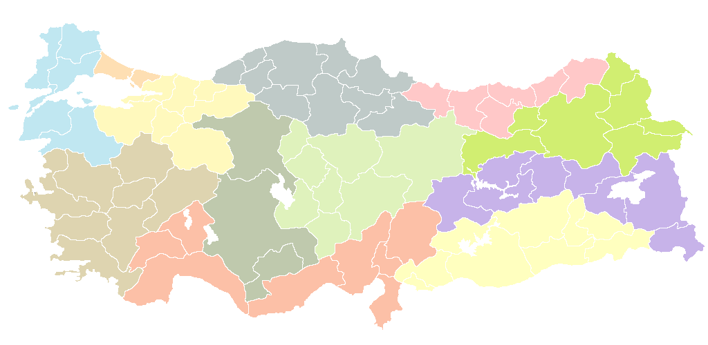
The NUTS-1 level in Turkey divides the country into 12 major statistical regions, designed to facilitate the collection and analysis of regional data for economic, social, and demographic planning. These regions group provinces based on geographic proximity, economic similarities, and population thresholds, aligning with the European Union's Nomenclature of Territorial Units for Statistics (NUTS) framework adapted for Turkey by the Turkish Statistical Institute (TÜİK).[16] The classification was established through Council of Ministers Decision No. 2002/4720 and has been used since 2002 to support harmonized regional statistics.[17] The 12 NUTS-1 regions are as follows:| Code | Region Name | Constituent NUTS-2 Codes |
|---|---|---|
| TR1 | Istanbul Region | TR10 |
| TR2 | West Marmara Region | TR21, TR22 |
| TR3 | Aegean Region | TR31, TR32, TR33 |
| TR4 | East Marmara Region | TR41, TR42 |
| TR5 | West Anatolia Region | TR51, TR52 |
| TR6 | Mediterranean Region | TR61, TR62, TR63 |
| TR7 | Central Anatolia Region | TR71, TR72 |
| TR8 | West Black Sea Region | TR81, TR82, TR83 |
| TR9 | East Black Sea Region | TR90 |
| TRA | Southeastern Anatolia Region | TRA1, TRA2 |
| TRB | Central East Anatolia Region | TRB1, TRB2 |
| TRC | East Anatolia Region | TRC1, TRC2, TRC3, TRC4 |
NUTS-2 Subregions
The NUTS-2 subregions in Turkey consist of 26 territorial units that aggregate the country's 81 provinces into larger statistical areas for regional analysis and policy implementation. These subregions are designed to balance population sizes between approximately 800,000 and 3 million inhabitants where possible, facilitating comparable data collection on economic, social, and demographic indicators across the nation. Established through collaboration between the Turkish Statistical Institute (TÜİK) and Eurostat, the NUTS-2 level serves as the primary framework for EU-aligned regional development programs and national planning, with each subregion falling under one of the 12 NUTS-1 regions.[1] The following table enumerates all 26 NUTS-2 subregions, their composing provinces, and estimated total population as of 2023 based on TÜİK's Address Based Population Registration System data. Populations are aggregated from provincial figures to reflect the subregional scale.| NUTS-2 Code | Subregion Name | Composing Provinces | Population (2023 est.) |
|---|---|---|---|
| TR10 | İstanbul | İstanbul | ~15.9 million |
| TR21 | Tekirdağ Subregion | Tekirdağ, Edirne, Kırklareli | ~1.9 million |
| TR22 | Balıkesir and Çanakkale | Balıkesir, Çanakkale | ~1.8 million |
| TR31 | İzmir | İzmir | ~4.5 million |
| TR32 | Aydın, Denizli and Muğla | Aydın, Denizli, Muğla | ~3.3 million |
| TR33 | Manisa and Afyonkarahisar | Manisa, Afyonkarahisar, Kütahya, Uşak | ~3.2 million |
| TR41 | Bursa | Bursa, Eskişehir, Bilecik | ~4.3 million |
| TR42 | Kocaeli Subregion | Kocaeli, Sakarya, Düzce, Bolu, Yalova | ~4.2 million |
| TR51 | Ankara | Ankara | ~5.8 million |
| TR52 | Konya | Konya, Karaman | ~2.6 million |
| TR61 | Antalya and Isparta | Antalya, Isparta, Burdur | ~3.4 million |
| TR62 | Adana and Mersin | Adana, Mersin | ~4.2 million |
| TR63 | Hatay and Kahramanmaraş | Hatay, Kahramanmaraş, Osmaniye | ~3.4 million |
| TR71 | Kırıkkale and its Environs | Kırıkkale, Aksaray, Niğde, Nevşehir, Kırşehir | ~1.6 million |
| TR72 | Kayseri and Nearby Provinces | Kayseri, Sivas, Yozgat | ~2.5 million |
| TR81 | Zonguldak and Karabük | Zonguldak, Karabük, Bartın | ~1.0 million |
| TR82 | Kastamonu and Çankırı | Kastamonu, Çankırı, Sinop | ~0.8 million |
| TR83 | Samsun and Tokat | Samsun, Tokat, Çorum, Amasya | ~2.8 million |
| TR90 | Trabzon | Trabzon, Ordu, Giresun, Rize, Artvin, Gümüşhane | ~2.6 million |
| TRA1 | Erzurum and Erzincan | Erzurum, Erzincan, Bayburt | ~1.1 million |
| TRA2 | Ağrı and Kars | Ağrı, Kars, Iğdır, Ardahan | ~1.1 million |
| TRB1 | Malatya | Malatya, Elazığ, Bingöl, Tunceli | ~1.8 million |
| TRB2 | Van and Muş | Van, Muş, Bitlis, Hakkâri | ~2.2 million |
| TRC1 | Gaziantep and Adıyaman | Gaziantep, Adıyaman, Kilis | ~2.9 million |
| TRC2 | Şanlıurfa and Diyarbakır | Şanlıurfa, Diyarbakır | ~4.0 million |
| TRC3 | Mardin and Batman | Mardin, Batman, Şırnak, Siirt | ~2.4 million |
NUTS-3 Provinces
The NUTS-3 level in the classification system for Turkey consists of the country's 81 administrative provinces, which have remained unchanged since the initial adoption of the NUTS framework in 2013 and align precisely with the national administrative divisions. These provinces serve as the finest granularity for regional statistical analysis, enabling detailed data collection on demographics, economy, and other indicators while facilitating comparability with EU standards. Basic demographics and characteristics for each NUTS-3 province are summarized below, including their parent NUTS-2 subregion, land area, population as of the end of 2024 from official address-based registration data, and the dominant economic sector based on the highest share of gross value added in 2022 (agriculture, industry, or services). Populations reflect total residents, and areas are fixed territorial measurements. Data are drawn from the Turkish Statistical Institute (TÜİK) for consistency and reliability.[22][23][24]| NUTS-3 Code | Province | NUTS-2 Code | Area (km²) | Population (2024) | Primary Sector |
|---|---|---|---|---|---|
| TR621 | Adana | TR62 | 13,844 | 2,274,106 | Industry |
| TRC12 | Adıyaman | TRC1 | 7,614 | 618,943 | Agriculture |
| TR332 | Afyonkarahisar | TR33 | 14,230 | 729,919 | Agriculture |
| TRA21 | Ağrı | TRA2 | 11,099 | 557,269 | Agriculture |
| TR712 | Aksaray | TR71 | 8,161 | 400,723 | Agriculture |
| TR834 | Amasya | TR83 | 5,654 | 314,846 | Agriculture |
| TR51 | Ankara | TR51 | 25,706 | 5,864,655 | Services |
| TR611 | Antalya | TR61 | 20,177 | 2,687,589 | Services |
| TRA24 | Ardahan | TRA2 | 5,581 | 93,462 | Agriculture |
| TR905 | Artvin | TR90 | 7,443 | 170,718 | Agriculture |
| TR321 | Aydın | TR32 | 8,007 | 1,140,411 | Agriculture |
| TR221 | Balıkesir | TR22 | 14,292 | 1,252,853 | Industry |
| TR813 | Bartın | TR81 | 2,120 | 200,981 | Industry |
| TRC32 | Batman | TRC3 | 4,654 | 658,869 | Industry |
| TRA13 | Bayburt | TRA1 | 3,652 | 81,579 | Agriculture |
| TR413 | Bilecik | TR41 | 4,307 | 213,029 | Industry |
| TRB13 | Bingöl | TRB1 | 8,125 | 282,225 | Agriculture |
| TRB23 | Bitlis | TRB2 | 6,707 | 354,131 | Agriculture |
| TR424 | Bolu | TR42 | 8,823 | 299,485 | Industry |
| TR613 | Burdur | TR61 | 6,887 | 276,691 | Agriculture |
| TR411 | Bursa | TR41 | 10,863 | 3,238,618 | Industry |
| TR222 | Çanakkale | TR22 | 9,817 | 533,586 | Agriculture |
| TR822 | Çankırı | TR82 | 8,194 | 185,709 | Agriculture |
| TR833 | Çorum | TR83 | 12,820 | 518,931 | Agriculture |
| TR322 | Denizli | TR32 | 12,134 | 1,056,200 | Industry |
| TRC22 | Diyarbakır | TRC2 | 15,168 | 1,792,091 | Services |
| TR423 | Düzce | TR42 | 2,611 | 417,248 | Industry |
| TR212 | Edirne | TR21 | 6,379 | 414,714 | Agriculture |
| TRB12 | Elazığ | TRB1 | 9,153 | 592,586 | Industry |
| TRA12 | Erzincan | TRA1 | 11,845 | 232,695 | Agriculture |
| TRA11 | Erzurum | TRA1 | 25,066 | 760,474 | Services |
| TR412 | Eskişehir | TR41 | 13,652 | 908,189 | Industry |
| TRC11 | Gaziantep | TRC1 | 6,115 | 2,123,710 | Industry |
| TR903 | Giresun | TR90 | 6,934 | 462,414 | Agriculture |
| TR906 | Gümüşhane | TR90 | 6,575 | 144,712 | Agriculture |
| TRB24 | Hakkâri | TRB2 | 7,121 | 279,341 | Agriculture |
| TR631 | Hatay | TR63 | 5,403 | 1,671,638 | Industry |
| TRA23 | Iğdır | TRA2 | 3,639 | 203,984 | Agriculture |
| TR612 | Isparta | TR61 | 8,933 | 453,704 | Agriculture |
| TR100 | İstanbul | TR10 | 5,461 | 15,701,602 | Services |
| TR31 | İzmir | TR31 | 11,891 | 4,479,525 | Services |
| TR632 | Kahramanmaraş | TR63 | 14,327 | 1,177,666 | Industry |
| TR812 | Karabük | TR81 | 4,074 | 249,481 | Industry |
| TR522 | Karaman | TR52 | 9,163 | 261,772 | Agriculture |
| TRA22 | Kars | TRA2 | 9,589 | 310,894 | Agriculture |
| TR821 | Kastamonu | TR82 | 13,301 | 373,946 | Agriculture |
| TR721 | Kayseri | TR72 | 16,970 | 1,452,666 | Industry |
| TR711 | Kırıkkale | TR71 | 4,651 | 299,491 | Industry |
| TR213 | Kırklareli | TR21 | 6,550 | 370,255 | Agriculture |
| TR715 | Kırşehir | TR71 | 6,584 | 245,657 | Agriculture |
| TR421 | Kocaeli | TR42 | 3,626 | 2,137,012 | Industry |
| TR521 | Konya | TR52 | 38,873 | 2,296,344 | Agriculture |
| TR333 | Kütahya | TR33 | 11,875 | 609,533 | Industry |
| TRB11 | Malatya | TRB1 | 12,313 | 807,931 | Agriculture |
| TR331 | Manisa | TR33 | 13,810 | 1,460,609 | Industry |
| TRC31 | Mardin | TRC3 | 8,978 | 902,763 | Agriculture |
| TR622 | Mersin | TR62 | 15,853 | 1,916,846 | Services |
| TR323 | Muğla | TR32 | 13,338 | 1,017,157 | Services |
| TRB22 | Muş | TRB2 | 8,196 | 428,427 | Agriculture |
| TR714 | Nevşehir | TR71 | 5,408 | 309,332 | Services |
| TR713 | Niğde | TR71 | 7,843 | 360,389 | Agriculture |
| TR902 | Ordu | TR90 | 6,257 | 766,634 | Agriculture |
| TR633 | Osmaniye | TR63 | 3,320 | 524,635 | Agriculture |
| TR904 | Rize | TR90 | 3,923 | 340,565 | Agriculture |
| TR422 | Sakarya | TR42 | 4,817 | 1,088,865 | Industry |
| TR831 | Samsun | TR83 | 9,579 | 1,368,755 | Industry |
| TRC34 | Siirt | TRC3 | 5,475 | 331,032 | Agriculture |
| TR823 | Sinop | TR82 | 5,878 | 216,067 | Agriculture |
| TR722 | Sivas | TR72 | 28,488 | 644,954 | Agriculture |
| TRC21 | Şanlıurfa | TRC2 | 19,242 | 2,188,179 | Agriculture |
| TRC33 | Şırnak | TRC3 | 6,396 | 570,190 | Agriculture |
| TR211 | Tekirdağ | TR21 | 6,190 | 1,159,197 | Industry |
| TR832 | Tokat | TR83 | 12,410 | 620,307 | Agriculture |
| TR901 | Trabzon | TR90 | 4,685 | 817,856 | Services |
| TRB14 | Tunceli | TRB1 | 7,774 | 86,612 | Agriculture |
| TR334 | Uşak | TR33 | 5,341 | 378,989 | Industry |
| TRB21 | Van | TRB2 | 19,069 | 1,140,372 | Agriculture |
| TR723 | Yozgat | TR72 | 13,600 | 402,728 | Agriculture |
| TR811 | Zonguldak | TR81 | 3,481 | 626,119 | Industry |
| TR425 | Yalova | TR42 | 924 | 249,060 | Industry |